Forest Classification Using High Spectral and Spatial Resolution Data
Forest Classification Using High Spectral and Spatial Resolution Data. Juho Lumme Helsinki University of Technology. Introduction. Forests are important natural resources for Finland They have financial, biological, social and cultural significance

Forest Classification Using High Spectral and Spatial Resolution Data
E N D
Presentation Transcript
Forest Classification Using High Spectral and Spatial Resolution Data Juho Lumme Helsinki University of Technology
Introduction • Forests are important natural resources for Finland • They have financial, biological, social and cultural significance • RS is an efficient tool for forest inventory • Imaging spectrometer measures spectral and spatial properties • Textural and spectral features are both used • Data is analysed using separability measures and classification
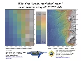
Test area • Area is located in Lammi (Southern Finland) • Contain: • Lakes • Rural areas • Cultivated fields • Coniferous forests • Deciduous forests • Size: 50 km long & 2 km wide.
AISA data • September 1999 • Six strips • Pixel size ~1 m • 17 channels (visible light and infrared) • Field surveys • Geological Survey of Finland • Over 250 training areas
Preliminary works & Feature extraction • Geometric and radiometric correction (METLA) • NDVI and image texture were used to screen forest areas • Principal Component Analysis • Texture features...
Texture measures • Measures were calculated using co-occurrence matrix • Window sizes: 25, 35, 45 pixels • Distances: 1, 3, 5 pixels • 9 texture measures • Homogeneity, contrast, dissimilarity, mean, standard deviation, entropy, angular second moment, correlation & inverse difference
Forest Classes • birch (seedling) • birch (young/old) • spruce (seedling) • spruce (young) • spruce (old) • pine (young) • pine (old)
Chan. Aver. sep. Chan. Aver. Sep. Win&dis 1 0.25 Homogeneity 0.58 25x25 5 5 0.43 Contrast 0.49 35x35 1 9 0.65 Dissimilarity 0.52 35x35 3 14 0.48 Mean 1.19 25x25 5 Separability measures – individual features • Class separation was poor • Best spectral channel: 9 • Best texture measure: mean • Spruce and pine mixed • Different age forest types mixed
Feature sets Aver. Sep. Channels: 9, 11, 13 1.36 Principal component channels: 1, 2, 3 1.04 Texture measures: Contrast, Dissimilarity, Mean 1.63 Channels: 9, 11, 13 Principal component channels: 1, 2, 3 NDVI channel Texture measures: Contrast, Dissimilarity, Mean 1.93 Separability measures – feature sets • Both spectral and textural features • All the classes were separated
Image classification • Bayes & Perceptron Neural Network • Several different feature sets
Image classification 1 = Bayes classification with principal component channels 2 = Bayes classification with principal component channels and texture features 3 = Bayes classification with three original image channels, principal component channels, NDVI and texture features 4 = Neural network classification with all original image channels and texture features • Seedling classes were rather uncertain • Bayes led to better results
Conclusion • Different age forest stands are hard to distinguish • Both spectral and textural features are useful on forest airborne hyperspectral data analysis • The results of this study are able to generalize to the satellite case
Grey level co-occurrence matrix • A GLCM is a two-dimensional histogram of grey levels for a pair of pixelswhich are separated by a fixed spatial relationship (PCI, Geomatica)