Download

1 / 19
190 likes | 399 Views
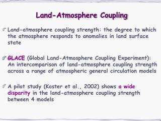
Using EO to understand Land-atmosphere feedbacks Chris Taylor, CEH Wallingford. Feedbacks via energy and water cycle. Koster et al 2004 Science. Atmosphere. Atmospheric forcing: Precipitation (radiation, temperature…). Fluxes: LE, H, (CO2, CH4…). Land surface state

E N D
Using EO to understand Land-atmosphere feedbacks Chris Taylor, CEH Wallingford
Feedbacks via energy and water cycle Koster et al 2004 Science Atmosphere Atmospheric forcing: Precipitation (radiation, temperature…) Fluxes: LE, H, (CO2, CH4…) Land surface state (soil moisture, snow, vegetation) 1. Precipitation impact on surface energy balance 2. Feedback on temperature via soil moisture and vegetation 3. Feedback on precipitation of soil moisture
1. Precipitation impact on surface energy balance: Determine where in Europe ET is limited by soil water ASCAT data from Vienna
Impact of soil water deficit on surface fluxes in East Anglia Data from 3 growing seasons ASCAT at 0930 (black) and 2130 (green) Potential to characterise soil water control on ET and evaluate models
2. Impact of antecedent precipitation on temperature: Seasonal cycle of vegetation in West Africa Shading: mean, contours: std dev
Correlation between NDVI and accumulated antecedent precipitation (atmosphere>land) See also Los et al 2006 Number of days prior to NDVI of rainfall accumulation Data at 14N across Western Sahel
Correlation between NDVI and atmospheric temperature (land>atmosphere) Spatial anomalies in temperature as a function of NDVI anomalies for 16-31 October in the years 2000-8 between 12 and 15N. Grid point anomalies in NDVI (shading) and 925 hPa temperature (18Z; K) and wind (6Z; m/s) for the period 16-31 October 2006 Can identify impact of precip-induced vegetation anomaly on temperature (and flow) in observations
Correlation between land surface and atmospheric temperature (land>atmosphere) For much of the year, areas observed to be greener are also cooler During wet season, areas with simulated increased H are correlated with higher temperatures Observed predictor of temperature Land model predictor of temperature Note: model forced by observed precip and radiation but climatological LAI Significant potential for improved atmospheric forecasts (weeks) across semi-arid tropics through vegetation EO
3. Feedback of soil moisture and rainfall Koster et al, Science (2004) Can we diagnose from earth observations where soil moisture influences rain?
Sensitivity of convection to soil moisture in observations: methodology CMORPH: Joyce et al., J. HydroMet. (2004) LPRM: Owe et al, JGR, (2008) • Collaboration with Richard de Jeu (VU Amsterdam) and Françoise Guichard (CNRM) • Near surface soil moisture from AMSR-E (LPRM) 0130 and 1330 local time • ASCAT surface soil moisture index 0930 and 2130 local time • 3-hourly precipitation – CMORPH, TRMM3B42, PERSIANN • 0.25° resolution, 2002-2011 • Statistics of afternoon/evening rain relative to underlying surface D D D D D D D D D W D D D D D D D D D D
Preference for rain over wet/dry soil? Statistics of 608 events in region of Australia Rain over drier soil found more frequently than expected Resampling indicates probability of this result occurring by chance 0.2% Rain over drier soil Rain over wetter soil
Sensitivity of convection to soil moisture in observations: global study results Taylor, de Jeu, Guichard and Harris, in prep Shading: Likelihood of finding results by chance Red (blue) => more rain events observed over dry (wet) soil AMSR-E ASCAT Analysis reveals that globally, rain more likely over drier soils… unexpected result
Evaluation of local feedback in models Taylor et al in prep Shading: Likelihood of finding results by chance Red (blue) => more rain events observed over dry (wet) soil Same analysis applied to diagnostics from models Institute of Numerical Mathematics HadGEM2 ARPEGE (CNRM) MRI ERA-Interim MERRA Models produce more rain over wetter grid boxes – opposite of observations
Physical mechanisms? Detailed results from the Sahel Taylor et al, Nature Geoscience 2011 All atmospheric conditions LFC<200hPa above surface LFC>300hPa above surface
Soil moisture, circulations and storm initiation Taylor et al, QJRMS 2010 Cold (wet) features Blue contours: Land Surface Temperature anomalies (LSTA) Map wet/dry areas with Land Surface Temperature (LST) at ~3km (MSG/LandSAF) Visible Imagery from Meteosat
The problem with (coarse-scale) models • Convection is parameterised: • tends to emphasise low level moisture • poor description of build-up of convection during day • too coarse to capture dynamical impact of surface heterogeneity Coarse resolution model (25km): positive soil moisture feedback Convection resolving model (2.2km): negative soil moisture feedback Hohenegger et al, J Clim 2009
Areas where NCEO can improve land representation in weather and climate models in coming years Benchmark hydrological control on surface energy balance at large scale in global models (LST, soil moisture) Techniques to constrain parameters e.g. adJULES Develop techniques to exploit atmospheric predictability contained within vegetation data Identify weak links in depiction of soil moisture-precipitation feedbacks
Vegetation across England Land cover (MODIS IGBP)