Download

1 / 29
290 likes | 322 Views
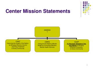
Our mission is to foster and sustain the environmental and economic well-being of the coast by linking people, information, and technology. Our focus areas include coastal hazards, coastal habitat, coastal information access and use, and capacity building.

E N D
Center Mission Foster and sustain the environmental and economic well being of the coast by linking people, information, and technology. Theme Areas • Coastal Hazards • Coastal Habitat • Coastal Information Access and Use • Capacity Building
Coastal Hazards - What are the Issues? • Coastal hazards can be defined as episodic or chronic destructive natural system events that affect coastal areas. These include: • Meteorological = hurricanes, tropical cyclones, northeasters, and coastal and riverine flooding • Geological = earthquakes, tsunamis, landslides, and chronic erosion • Growing concern over continuing worldwide rise in disaster loss totals • Estimated cost is $10 to $50 billion annually in U.S. • Global climate change or natural cyclical trends • Improvements in disaster monitoring and loss reporting • Increased human exposure in hazardous locations
Risk Assessment • Local government interaction • Insurance industry involvement • Training on mitigation • Regional vulnerability atlas • Mitigation workshops • GIS as decision support tool Coastal Hazards
Coastal Hazard Mitigation • Multi-disciplinary efforts focusing on community risks and vulnerabilities and the true costs of hazards • Hazard Reduction • Altering the coastal environment (erosion control, beach nourishment) • Strengthening the built environment (windproofing, elevating structures) • Hazard Avoidance • Managing development in high hazard areas (land use planning, economic incentives, education) • Prohibiting development in high hazard areas (zoning)
Vulnerability Assessment Methodology • Hazard Identification • Hazard Analysis • Critical Facilities Analysis • Societal Analysis • Economic Analysis • Environmental Analysis • Mitigation Opportunities Analysis
Input Storm Surge Wind Flood Tornado Earthquake Wildfire Hazardous Spills Toxic Release Hazard Identification List of prioritized hazards for use in developing mitigation strategies and prioritizing mitigation projects. Output Hazard Identification What hazards are you concerned about? How would you prioritize them?
Hazard Identification Step 1a Identify hazards. Step 1b Apply relative priority scoring system.
Input SLOSH Model Inland Winds Model Floodplain Maps Soils Land Cover Erosion Rates Hazardous Waste Hazard Analysis Geographically defined risk consideration areas to be used as a filter for analyzing vulnerability and targeting high-risk locations for mitigation projects. Output Hazard Analysis Where are your risk consideration areas? How would you prioritize these risk areas?
Hazard Analysis Step 2a Map risk consideration areas for hazards. Step 2b Prioritize risk consideration areas within each hazard, where possible.
Input Police Fire/EMS Hospitals Shelters Utilities Communication Government Facilities Roads & Bridges Schools Critical Facilities Analysis A systematic assessment of the vulnerability of critical lifelines or key resources to various hazard impacts. Can be used to identify and prioritize mitigation projects. Output Critical Facilities Analysis What are your critical facilities and where are they located? How vulnerable are they to physical and operational impacts from hazards?
Critical Facilities Analysis Step 3a Identify critical facilities categories. Step 3b Complete a critical facilities inventory. Step 3c Conduct vulnerability analysis on critical facilities.
Critical Facilities Analysis Types of Critical Facilities in Inventory • Shelters • Schools • Medical • Fire/EMS • Police • Utilities • Communications • Transportation • Government Facilities • Miscellaneous Information to Collect in the Inventory • Facility Name • Address • Owner/Operator • Contact • Phone • Alternate Contact • Alternate Phone • x and y Coordinate
Input Poverty Age Minority Population No Vehicles Female Households Rental Households Public Assistance Societal Analysis Geographically defined areas of high risk coupled with minimal personal resources for hazard recovery. Can be used to develop mitigation strategies and target high-need locations. Output Societal Analysis Where are your high-need neighborhoods? How vulnerable are they to hazard impacts?
Societal Analysis Step 4a Identify societal need indicators and collect relevant data. Step 4b Locate high-need areas. Step 4c Identify high-need areas that intersect with high risk locations Step 4d Conduct general inventory of high-need/high risk locations.
Societal Analysis High Need Areas on Surge High Need Areas
Input Agriculture Mining Construction Manufacturing Transportation Wholesale & Retail Services Finance, Insurance Real Estate Economic Analysis Geographically defined areas of high risk coupled with potential impacts on vulnerable sectors of the economy. Can be used to develop mitigation strategies and target high impact economic sectors. Output Economic Analysis What are your primary economic sectors and how vulnerable are they to hazards? Where are your largest employers and how vulnerable are they to hazard impacts?
Economic Analysis Step 5a Identify primary economic sectors and locate clusters or economic centers. Step 5b Identify intersection of economic centers and high risk locations. Step 5c Conduct general inventory of high risk economic centers. Step 5d Identify large employers. Step 5e Conduct vulnerability assessment of large employers (similar to critical facilities.)
Environmental Analysis Where are your hazardous materials located and how vulnerable are they to natural hazards? How vulnerable are critical natural resources to secondary hazard impacts? Input Hazardous Materials Toxic Release Sites Oil Facilities Ports Marinas Discharge Sites Environmental Analysis Geographically defined areas of high risk coupled with potential of secondary environmental impacts. Can be used to target mitigation projects that will protect sensitive natural resources. Output
Environmental Analysis Step 6a Identify secondary hazard risk consideration sites. Step 6b Identify intersections of secondary risk sites with high natural hazard risk areas and environmentally sensitive areas to identify priority locations. Step 6c Conduct vulnerability assessments of priority secondary risk sites (similar to critical facilities.)
Input Policy Status Undeveloped Land Age of Housing Stock Population Projections Land Cover Change Zoning Mitigation Opportunities A systematic assessment of existing and potential land uses focused on high hazard areas. Can be used to evaluate future impacts of proposed hazard mitigation strategies. Output Mitigation Opportunities Analysis Where are your best opportunities for mitigation policy changes to have significant impacts on future hazard vulnerability?
Mitigation Opportunities Analysis Step 7a Identify areas of undeveloped land and the intersection with high risk areas. Step 7b Inventory land for existing policies (zoning, floodplain regulations) to determine adequacy of existing policies to prevent unwise development.