Download
1 / 14
140 likes | 269 Views
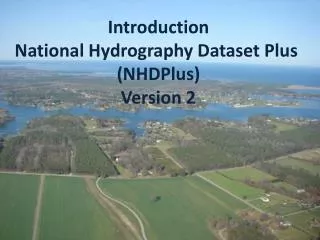
Audit of Geographic Feature Names in the National Hydrography Dataset (NHD). James Seay Kentucky Division of Water Frankfort, KY James.seay@ky.gov 2012 Kentucky GIS Conference September 28, 2012. What is the National Hydrography Dataset (NHD)?.

E N D
Audit of Geographic Feature Names in the National Hydrography Dataset (NHD) James Seay Kentucky Division of Water Frankfort, KY James.seay@ky.gov 2012 Kentucky GIS Conference September 28, 2012
What is the National Hydrography Dataset (NHD)? GIS data set built by the US Geological Survey (USGS) Contains hydrographic features such as lakes, ponds, rivers, streams, dams, canals and stream gages. Stream flowlines have associated flow directions to allow for its use in hydrographic modeling. Names for rivers, lakes and other hydrographic features taken from the federal Geographic Names Information System. Work on current high resolution NHD (1:24k scale) begun in 2002, completed in 2007. Kentucky Division of Water is the state NHD Data Steward.
What is the Geographic Names Information System (GNIS)? Database holds the federally recognized names of geographic features across the USA. Maintained by the US Board of Geographic Names (BGN). BGN collecting geographic names since 1890. Has partnerships with various state, federal and local agencies to collect and reconcile geographic place names. The Kentucky portion of the GNIS has existed since 1979.
Common NHD names issues NHD feature missing GNIS ID and/or Name Incorrect NHD feature bears GNIS ID/Name GNIS ID/Name assigned to incorrect headwaters stream. NHD Feature has a GNIS ID but has not been digitized into the NHD.
Common GNIS Issues Duplicate GNIS records Occurs along state borders Artifact from early days of the GNIS database Misplaced coordinates for the mouth and/or source of a stream Associated geographic feature no longer exists (ex. drained lake/reservoir) BGN designates ‘lost’ geographic features as ‘historical’ No GNIS records are deleted.
Reporting GNIS Issues Problems with the GNIS are to be reported to the BGN at gnis_manager@usgs.gov. Include GNIS ID and Name of problem feature. The nature of the problem (ex. duplicate GNIS records) The name of the USGS 7.5 minute topographic map quad in which this feature may be found. To propose or change a name: http://geonames.usgs.gov/domestic/name_form.htm
Reporting NHD Issues NHD Issues may be reported to: Kentucky Technical Point of Contact (POC): James Seay James.seay@ky.gov USGS NHD POC for Kentucky: Elizabeth McCartney emccartney@usgs.gov
For more information US Board of Geographic Names (for the latest GNIS data and information about the GNIS database): http://geonames.usgs.gov US Geological Survey NHD page: http://nhd.usgs.gov