Download
1 / 37
460 likes | 714 Views
Weather and Climate. Climate vs. Weather. Weather: Short term state of the atmosphere. Temperature, humidity, cloud cover, precipitation, winds, visibility, air pressure, air pollution, etc… Climate: The average weather conditions in an area over a long period of time

E N D
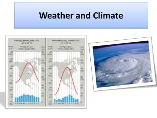
Climate vs. Weather • Weather: Short term state of the atmosphere. • Temperature, humidity, cloud cover, precipitation, winds, visibility, air pressure, air pollution, etc… • Climate: The average weather conditions in an area over a long period of time • Described by temperature and precipitation
Measurement Definition Instrument How hot or cold the air is The weight of the air How fast the wind is blowing Where the wind is blowing from Amount of water vapor in the air Amount of rain or snow that falls M E A S U R I N G W E A T H E R Thermometer Temperature Air Pressure Barometer Wind Speed Anemometer Weather Vane Wind Direction Humidity Hygrometer Rain Gauge Precipitation
Measuring Weather Instruments used in measuring weather in the upper atmosphere • Radiosonde: • a package of instruments that is carried aloft by balloons to measure upper atmospheric conditions, including temperature, dew point, and wind velocity • sends measurements as radio waves to a receiver that records the information. • When the balloon reaches a very high altitude, the balloon expands and bursts, and the radiosondeparachutes back to Earth. • Radar: radio detection and ranging • a system that uses reflected radio waves to determine the velocity and location of objects • The newest Doppler radar can indicate the precise location, movement, and extent of a storm. It can also indicate the intensity of precipitation and wind patterns within a storm. • Weather Satellites: • Satellite images provide weather information for regions where observations cannot be made from ground. • The direction and speed of the wind at the level of the clouds can also be measured by examining a continuous sequence of cloud images. • Satellite instruments can also measure marine conditions. • Computers • Solving very difficult mathematical equations • Store weather data • Can provide information that is useful in forecasting weather changes
Measuring Climate Continue • Long term weather measurements • Satellites • Geological Evidence • Evidence of glaciation • Rock layers
Creation of Wind that eventually leads to weather and climate.
Flashlight Mini Lab • Flashlight Demo: • Predictions: Which will have the most energy per given area, the 90 degree or the 30 degree angle flashlight? • Hold the flashlight at 90 degree angle and about 10 inches above your paper • Draw an outline around the beam • Count the number of squares: • Hold the flashlight at 30 degree angle and about 10 inches above your paper • Draw an outline around the beam • Count the number of squares: • Which has the most energy per given area? • 90 degree
Direct vs. Indirect Sunlight • Sun gives off the same amount of radiation and stays the same temperature! • The tilt of the Earth (23 ½ degrees) determines the concentration of the sun in a given area • Small area = large concentration • Big area = less concentration
http://www.sci.uidaho.edu/scripter/geog100/lect/02-energy-seasons-atmosphere/02-pt-1-solar-energy.htmhttp://www.sci.uidaho.edu/scripter/geog100/lect/02-energy-seasons-atmosphere/02-pt-1-solar-energy.htm
Winter in Northern Hemisphere • Tilted away from the Sun • Cooler Temperatures = Cooler Climates • Higher latitudes • Sun’s rays hit Earth at a smaller angle • Solar energy is spread out over a larger area windows2universe.org
Summer in Northern Hemisphere • Tilted towards the Sun • Higher Temperatures = Warmer Climates • Lower latitudes • Sun’s rays hit Earth around 90 degrees • Solar energy is more direct, smaller areas windows2universe.org
Uneven Heating of the Earth • Is warm air more or less dense the cold air? • Less Dense • If you have cold air at the poles and warm air at the equator where do you think each air mass will want to move and why? • Cold air mass will move toward the warm air mass and the warm air mass will move toward the cold air mass because of convection. • Convection: the movement of matter due to differences in the density that are caused by temperature variations; can result in the transfer of energy as heat. • Convection currents/Density currents • The convection of air is a key piece in creating wind.
Atmospheric Pressure(Air Pressure) • atmospheric pressure: the force per unit area that is exerted on a surface by the weight of the atmosphere • decreases as altitude increases • changes as a result of differences in temperature and in the amount of water vapor in the air
Pressure Gradient • Uneven heating of the Earth’s surface creates pressure gradients. • Cause air to move form high pressure areas to low pressure areas creating wind • http://www4.uwsp.edu/geo/faculty/ritter/animation/atmosphere/pressure_gradient.gif
Question • Why doesn’t the wind blow straight to the North and South pole from the equator? • Rotation of the Earth, which we call the Coriolis Effect
Coriolis Effect • Coriolis effect: the curving of the path of a moving object from an otherwise straight path due to Earth’s rotation • Circulation of atmosphere and ocean currents are effected. • http://www.youtube.com/watch?v=aeY9tY9vKgs&feature=related • Hold the spherical device in your hand and rotate it counterclockwise (West to East) and look at it from the top. Which way is it rotating? • counterclockwise • Now keep rotating it counterclockwise (West to East) and look from the bottom, which why is it rotating? • Clockwise
High and Low Pressure Wind Directions • High pressure winds move outwards • Low pressure winds move inwards • Both are curved because of the Coriolis Effect
Cyclones and Anticyclones • The hole column of air around a high or low pressure. • Cyclones: when air moves into low areas it collides or converges. The collision causes the air to lifted and then diverge. • Part of how storms are created • Anticyclones: air converges towards the surface and then once it reaches the surface it is forced out (divergence) • Nice weather
Global Wind Patterns • trade wind: • Blowfrom east to west • Latitudes30º latitude to the equator in both hemispheres • Westerlies: • Blow from west to east • between 30º and 60º latitude in both hemispheres • descending air moving toward the poles is deflected by the Coriolis effect • Polar easterlies: • Blow from east to west • between 60 and 90 latitude in both hemispheres • Surface winds created by the polar high pressure are deflected by the Coriolis effect • Each of the three types of winds are affected by the High and Low pressures • Both winds and pressure zones have an impacted on determining climates around the global. Dry air Sinking Moist air rising Dry air Sinking Moist air rising Dry air Sinking Moist air rising Dry air Sinking
Jet Stream • a narrow band of strong winds that blow in the upper troposphere • These wind exist in the Northern and Southern Hemisphere. • Subtropical jet stream. • Polar jet streams: • reach speeds of 500 km/h • can affect airline routes and the paths of storms.
How Global Winds Effect Ocean Surface Currents • Trade winds cause the ocean currents to be pushed westward across the tropical latitudes of all three major oceans. • Westerlies cause the ocean currents to be pushed eastward in the higher latitudes.
Coriolis Effect on Oceans • Cause gyre • Huge circle of moving ocean water found above and below the equator • Northern hemisphere they move clockwise • Southern hemisphere they move counterclockwise
El Nino • Trade wind either weaken or switch direction • Cause upwelling to weaken or stop off the coast of South America and the fish die from heat and lack of nutrient from the upwelling process. • Causes flooding in South America (Peru) and droughts in Indonesia and Australia. • Mess up the weather for the rest of the Global.