Download
1 / 17
170 likes | 298 Views
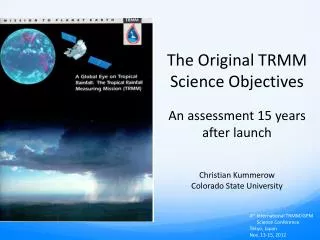
The Original TRMM Science Objectives An assessment 15 years after launch Christian Kummerow Colorado State University. 4 th International TRMM/GPM Science Conference Tokyo, Japan Nov. 13-15, 2012. The TRMM Satellite. TRMM Mission “Success Criteria”.

E N D
The Original TRMM Science Objectives An assessment 15 years after launch Christian Kummerow Colorado State University 4th International TRMM/GPM Science Conference Tokyo, Japan Nov. 13-15, 2012
TRMM Mission “Success Criteria” • A “fully successful” TRMM mission would be one in which PR, TMI and VIRS are working as specified. LIS and CERES are useful complements but they are EOS instruments but are NOT part of the core TRMM mission. • “Successful” status could still be achieved if the VIRS were to fail. This would make it more difficult to use TRMM to calibrate geostationary IR rain observations. Some physics that can be inferred from the cloud tops would also be lost but the core rainfall structure observations of TRMM would remain. • "Minimally successful" status would be the situation where TMI does not perform as specified. The sampling component of TRMM would be seriously jeopardized and transferring knowledge gained from TRMM to previous and future microwave sensors would become extremely difficult. Since all channels on TMI provide a unique perspective of rainfall, defining which channels or combinations of channels could fail to maintain a “successful” mission criteria is extremely difficult. • If PR does not work, the mission cannot be called successful. TMI offers a modest improvement over previous sensors but EOS-PM as well as ADEOS-II both have radiometers with very similar capabilities. The only question that TRMM will then be able to address is one of the diurnal variability of rainfall over the tropical oceans.
TRMM “Science” Objectives • To obtain and study multi-year science data sets of tropical and subtropical rainfall measurements • To understand how interactions between the sea, air, and land masses produce changes in global rainfall and climate • To help improve modeling of tropical rainfall processes and their influence on global circulation in order to predict rainfall and variability at various time scale intervals. • To test, evaluate, and improve the performance of satellite rainfall estimate measurements and techniques
TRMM “Science” Objectives • To obtain and study multi-year science data sets of tropical and subtropical rainfall measurements: Launch and successfully operate satellite and data system for 3 years. • To understand how interactions between the sea, air, and land masses produce changes in global rainfall and climate: Produce accurate maps of global precipitation at 5°x5° monthly resolution for at least 3 years. Calibrate previous rainfall estimates to extend time series. • To help improve modeling of tropical rainfall processes and their influence on global circulation in order to predict rainfall and variability at various time scale intervals: Derive Latent Heating products in the tropics; Map Diurnal Cycle of Precipitation; Make data available to modeling community; • To test, evaluate, and improve the performance of satellite rainfall estimate measurements and techniques: Operate a quantitative validation program and reprocess data as warranted.
TRMM Data Availability +5% 2.76mm/day -5%
Thirteen-year (1998-2010) TRMM Composite Climatology (TCC) Climatological value is mean of three input products at each 0.5 lat./long. grid from Adler/Wang Standard deviation (σ) among the three products is an estimate of error—note E. Pac. peak values (σ/mean= 1.3/9 = 14%)
Time series of precipitation compared to ENSO 3.4 index +5% 2.76mm/day -5%
Latent Heating by convection 98-07 June-Aug Latent heating at 7.5kmdeep convection Latent heating at 2.0kmcumulus congestus Latent heating by convection is estimated utilizing TRMM PR (Shige et al. 2004). Significant distribution of cumulus congestus regime emerged out over moderately warm water with large-scale atmospheric subsidence. (Takayabu et al. 2010)
TRMM Rainfall: Latent Heating Profiles MJO Phase • Comprehensive estimates of how rainfall is directly related to latent heat release (LHR) • Quantification of LHR related to ENSO, MJO • Comparisons to global models Phase 1 Phase 2 Phase 3 Phase 4 Phase 5 Phase 6 Phase 7 Phase 8 Courtesy of W.-K. Tao From Jiang et al. (2011)
Fine-scale diurnal variation of precipitation 0.1 degree1998-2010 0.1 degree 1998-2010 Distinct difference in peak time of precipitation is found over land (mostly afternoon), over the oceans (midnight to early morning), and coastal regions (morning). Orographic effects and large-scale diurnal migration are also observed. Hirose et al. 2008, JAMC
The TRMM Precipitation Feature Database • Continuously updated database of precip. features • Easy subsetting by location, time, feature size, dbZ, or other parameters • Identifies occurrences of extremes, rain feature population statistics, vertical structure Occurrence of 20 dbZ for different heights
Impact of Asian Pollution on Rainfall? Importance of Radar and Passive Microwave on Same Satellite Remaining Differences between Passive Microwave and Radar Retrievals --an extreme example TMI shows significant rain area, but PR shows very little Result probably due to aerosol effects (pollution) on size distribution of cloud/rainfall droplets (high cloud liquid water content, but small amount of rain) Berg and Kummerow
Summary Estimated Publications by year • Space standard for measuring precipitation • Improved climatology of tropical rainfall and variations • Vertical hydrometeor/heating structure and diurnal signal • Improved climate and weather modeling • Impact of humans on precipitation • Hurricane/typhoon structure/evolution • Multi-satellite (~3-hr) rainfall analyses using TRMM+other satellites • Flood and agricultural applications • Operational use of data by weather agencies. >3000 scientific journal articles published using TRMM data
The Future GPM is on the horizon. It expands the concept of calibration satellite and constellation approach to sample quickly changing rainfall. It was borne from concepts in the US and Japan dating back to 1997/1998 (ATMOS-A1/GIROS) Time to think of the next step forward? Clouds and Precipitation? Many unanswered questions about transition processes as a function of aerosols and large scale regimes. Or the entire fresh water budget – from evaporation, to water vapor, clouds, precipitation and storage in its various forms? How do we do this as a global community with real budget and political constraints?