Download
1 / 51
510 likes | 640 Views
Chapter 24 delves into the diverse geography of South Asia, a subcontinent rich in natural resources and bordered by majestic mountains and oceans. It examines key features such as the Himalayas, the fertile Indo-Gangetic Plain, and the unique landscapes of the Maldives. The chapter highlights the critical role of natural resources in sustaining life, from irrigated agriculture to forestry, while also addressing environmental issues like deforestation and climate variations. With over a billion people, South Asia's landforms are integral to its cultural and economic identity.

E N D
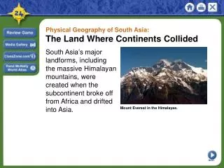
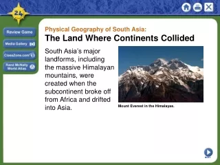
The Land Where Continents Collided Chapter 24
Landforms and Resources Chapter 24 Section 1
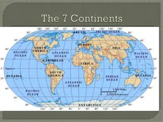
Main Ideas South Asia is a subcontinent of peninsulas bordered by mountains and oceans. A wide variety of natural resources helps sustain life in the region.
Overview South Asia 1. India 2. Pakistan 3. Bangladesh 4. Bhutan 5. Nepal 6. Sri Lanka 7. Maldives
Mountains and Plateaus • Subcontinent • A large landmass that is smaller than a continent • South Asia is often referred to as the Indian subcontinent • One half the size of the continental US • More than one billion people
Mountains and Plateaus • Natural barriers separate South Asia from the rest of Asia • Mountain Ranges • Indian Ocean • Arabian Sea • Bay of Bengal
Northern Mountains The gradual collision of two tectonic plates forced the land upward into enormous mountain ranges. These mountains, which are still rising, now form the northern edge of the South Asian subcontinent.
Northern Mountains The Himalayas form a giant barrier between the Indian subcontinent and China. Mt. Everest, the world’s tallest peak, sits at the heart of the Himalayas. Within these mountains are the remote, landlocked kingdoms of Nepal and Bhutan. Himalayas
Northern Mountains Panoramic view from the top of Mount Everest
Northern Mountains Hindu Kush Khyber Pass
Northern Mountains K2 Karakoram Mountains
Deccan Plateau Eastern Ghats Western Ghats Southern Mountains Vindhya Range
Indus River Brahmaputra River Ganges River Rivers, Deltas, and Plains The Three Great Rivers
Fertile Plains • Alluvial plain • Land that is rich farmland • Composed of clay, silt, sand, or gravel deposited by running water • The Indo-Gangetic Plain is one of the most fertile farming regions in the world.
Fertile Plains The Indo-Gangetic Plain is the most heavily populated part of South Asia.
Fertile Plains One of the world’s most arid regions—the Thar, or Great Indian Desert.
The Maldives Archipelago • Archipelago • A set of closely grouped islands • island group • The Maldives consist of 1,200 small islands
The Maldives Archipelago • Atoll • A ring-like coral or string of small islands surrounding a lagoon • Most of the Maldives are this type
Natural ResourcesWater and Soil Irrigation, Fishing, Transportation & Power Fishing in Bangladesh Traditional boat on the Indus in Pakistan Irrigating a farm along the Ganges Hydroelectric plant in northern India
Forests • Timber and other forest products are important to the region’s economy as many of the woods found here are highly sought after. • Less than one-fifth of India’s original forests remain. • Deforestation has caused major problems to the ecosystem in Bangladesh. Deforestation causes soil erosion, flooding, landslides, and loss of wildlife habitats.
Climate and Vegetation Chapter 24 Section 2
Main Ideas Climate conditions in South Asia range from frigid cold in the high mountains to intense heat in the deserts. Seasonal winds affect both the climate and vegetation of South Asia.
Climate-Wet and Dry, Hot and Cold • Half the climate zones that exists on earth can be found in South Asia. • Six different climate zones. • The Highland Zone has the coldest climate. • Area of the Himalayas and other northern mountains, where snow exists year-round.
Climate-Wet and Dry, Hot and Cold • Humid Subtropical Zone • Includes the foothills and valleys of Nepal, Bhutan, and northern India • much warmer than highland zone • The Indo-Gangetic Plain also occupies much of this region.
Climate-Wet and Dry, Hot and Cold • Semiarid Zone • A region of high temperatures and light rainfall • Found at the western end of the Plain and in parts of the Deccan Plateau.
Climate-Wet and Dry, Hot and Cold • Desert Zone • Covers much of the lower Indus Valley, in the borderlands of western India and southern Pakistan. • The driest part of this area, the Thar Desert, gets very little rain—averaging 10 inches a year.
Climate-Wet and Dry, Hot and Cold • Tropical Zones • Found along the western and eastern coasts of India and in Bangladesh. • Temperatures are high, and rainfall is heavy--- • Tropical Wet has much more precipitation than the Tropical Wet and Dry.
Monsoons • Monsoon • Seasonal wind • Last from June to September • Brings crucial rainfall to South Asia • Also brings severe hardship Annual monsoons replenish soil nutrients and form fertile farmland but often inundate Bangladesh.
Cyclones • Cyclone • A violent storm with fierce winds and heavy rain • The most extreme weather pattern of South Asia • Most destructive in Bangladesh • Called hurricanes in the Western hemisphere
Vegetation: Desert to Rain Forest • The most forested parts of South Asia lie within the Tropical Wet Zone, particularly the western coast of India and southern Bangladesh. Lush rain forests of teak, ebony, and bamboo are found there, along with mangroves in the delta areas.
Vegetation: Desert to Rain Forest • In the Highland Zone, which includes northern India, Nepal, and Bhutan, there are forests of pine, fir, and other evergreens.
Vegetation: Desert to Rain Forest • The river valleys and foothills of the most of India make up the Humid Subtropical Zone which have forests of sal, oak, chestnut, and various palms.
Vegetation: Desert to Rain Forest • In the semiarid areas of South Asia, such as the Deccan Plateau and the Pakistan-India border, there is less vegetation. The main plant life is desert shrubs and grasses.
Vegetation: Desert to Rain Forest • The driest areas, like the Thar Desert, have little plant life, and as a result, few people live there.
Vegetation: Desert to Rain Forest • The Tropical Wet and Dry areas of northern Sri Lanka produces both grasses and trees
Human-Environment Interaction Chapter 24 Section 3
Main Ideas Rivers play a central role in the lives of South Asians. Water pollution and flooding pose great challenges to South Asian countries.
Living Along the Ganges • Hinduism is religion of most Indians. • The Ganges River is an important water source and a sacred river. • People feel it is too sacred to be harmed by pollution • Hindus believe the water has healing powers
The Polluted Ganges • The major polluting industries on the Ganges are the leather industries, which use large amounts of chromium and other chemicals. • Nearly 1 billion liters of waste per day, of mostly untreated raw sewage is dumped into the river. • Inadequate cremation procedures contributes to a large number of partially burnt or unburnt corpses floating down the Ganges, in addition to livestock corpses.
Controlling the Feni River • Rivers in Bangladesh are crucial to the country’s survival. • The Feni River overflows its coastal plain during the wet season and cyclones often cause storm surges. • Storm surges • High water level brought by a cyclone that swamps low-lying areas
Controlling the Feni River • To control the Feni a dam was built in 1985. • Bangladesh had one key asset for such a project—abundant human resources. • The base of the dam was made of mats of bamboo weighed down with boulders, and covered by clay-filled bags. • The dam was built to form an estuary.
Controlling the Feni River Feni Dam