Download
1 / 39
390 likes | 573 Views
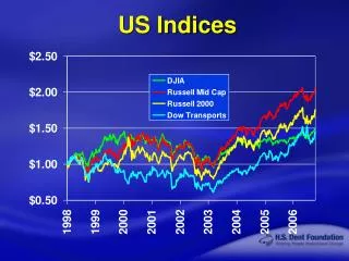
More Ocean Indices. Paul Knight, Richard Grumm and Paul Roundy PSU Meteorology and NWS State College. Pacific Decadal Oscillation PDA/NPO Oceanic Index. The Pacific Decadal Oscillation ( PDO ) is an index of long-term variability of the sea-surface temperatures of the North Pacific Ocean.

E N D
More Ocean Indices Paul Knight, Richard Grumm and Paul Roundy PSU Meteorology and NWS State College
Pacific Decadal OscillationPDA/NPO Oceanic Index • The Pacific Decadal Oscillation (PDO) is an index of long-term variability of the sea-surface temperatures of the North Pacific Ocean. • reflects the dominant mode of SST over the North Pacific Ocean. • The PDO can impact the climate. • A characteristic that distinguishes the PDO from ENSO is that 20th century PDO events have tended to persist for 20-to-30 years, while ENSO events have typically persisted for 6 to 18 months. • also known as the North Pacific Oscillation (NPO) and the terms can be used interchangeably.
Phases of the PDO/NPO • the high phase of the NPO is the term used to describe a warm PDO and the low phase of the NPO is the term used to describe the cold PDO. • Recent research indicates a clear link of the PDO to the ENSO. The Climate Prediction Center thinks that the sign of the PDO may be a composite of a longer term ENSO cycle.
The cold phase • Cold PDO regimes prevailed from 1890-1950 • cold phase index is positive • the PDO was higher then average from 1920 to 1950. • cold phase may behave like a weak La Nina • note colder water in tropical Pacific dominates • may enhance impacts of La Nina when they are in phase • The cold phase occurs when there is warmer water over the western and central Pacific associated with a deepened Aleutian low. • Colder water over eastern and tropical Pacific
The warm phase • Warm PDO regimes dominated from 1950 into the 1990’s. • During the warm phase, the PDO is negative. • On a 30 year time scale, the PDO was lower than average from 1950 to 1980. • A negative PDO may act like an El Nino. • The warm phase occurs when there is colder water over the western and central Pacific.
The warm phase • Warmer and drier winters in the northern regions of the nation and wetter and cooler winters observed in the southern areas of the United States. • El Nino is associated with a negative SOI, weak tropical easterlies and warm Nino3.4 SST’s.
PDO Summary • Relates to ENSO cycles • Frequency of El Nino can be related to PDO phase during the past 30-40 years. • PDO can interfere both constructively and destructively with ENSO. • PDO may not be independent of ENSO • High NPO (warm phase) • Cold water in north/central Pacific • Warm water along west coast NOAM (fishing industry named phases!) • May enhance El Nino effects in eastern US • Low NPO (cold phase) • Warm water in north/central Pacific • La Nina like impact connect with weaker storm tracks, farther north [dry-nation]
Referemces Rogers, J.C., 1997: North Atlantic storm track variability and its association to the North Atlantic Oscillation and climate variability of Northern Europe. Journal of Climate10(7), 1635-1647. Hurrell, J.W., 1995: Decadal trends in the North Atlantic Oscillation and relationships to regional temperature and precipitation. Science269, 676-679. Wallace, J.M. and David S. Gutzler, 1981:"Teleconnections in the Geopotential Height Field during the Northern Hemisphere Winter" Mon. Wea. Review,109,784-812. Teleconnections Linking Wolrdwide Climate Anomalies. ed. M.H. Glantz, R.W. Katz and N. Nicholls, Cambridge University Press, 1991. Rogers, J.C. and H. Van Loon, 1979: "The Sea-Saw in winter temperatures between Greenland and Northern Europe. Part II. Some atmospheric and oceanic effectes in middle and high latitudes." Mon Wea. Rev. ,107, 509-519.
The Large-Scale ConvectiveDisturbance • Tropical Intraseasonal or Madden-Julian Oscillation
What is the MJO? • Large-scale disturbance of deep convection and winds that controls up to half of the variance of tropical convection in some regions • Brief history
MJO- an intraseasonal event • Prior to 1971, it was thought that virtually all variability in the weather conditions within a given season in the Tropics was random. • There were indications of interseasonal variations, such as the Southern Oscillation • Studies of Tropical rainfall and pressure changes showed additional oscillations
A 30-60 day oscillation in the coupled Tropical ocean-atmosphere system An eastward progression of enhanced and suppressed convection Low level and upper level wind patterns show distinct anomalies Strong year to year variability in MJO that is related to ENSO cycle The MJO - A Description
Wave Cooperation • Kelvin and Rossby waves linked by convection, land, and air-sea interaction combine to produce the observed disturbance.
The 3D view of MJO • Axis of coupled convection/suppressed convection usually between 5S-5N • SST feedback could be sensitive enough to either trigger or help propagate the wave
Convective Kelvin Wave z Convection removes Some of the accumulating mass, slows propagation H L x Propagation speed: less than 20 ms-1
MJO Statistics • Eastward propagation, 4 +/- 2 ms-1. Also has standing wave behavior • 30-60 day period • Wavenumber 1-4 (planetary scale) • Interacts with midlatitudes, but some of this is nonlinear and hard to quantify
The Satellite View of MJO • The MJO is noted by a cluster of thunderstorms drifting eastward along the equatorial Indian and Pacific oceans.
Simplified Madden-Julian Oscillation Composite OLR from A.J. Matthews, 2000.
The Velocity Potential View • The 200 mb velocity potential illustrates yet another way of detecting both the presence and movement of the MJO. This is noted by a couplet of anomalies.
Disturbances in the 500mb Flow • Another method of detecting the presence of the MJO is following height and wind perturbations in the 500 mb flow over the equatorial Pacific ocean.
How Does It Propagate? • Is a matter of debate, but, probably involves • interactions with equatorial waves • Kelvin wave • Equatorial Rossby wave • Feedbacks from convection • Sea surface temperatures—air-sea interaction • Land interactions
MJO - Probable Cause • Wave-CISK Theory (Chang, Lau, Lim) • slow moving wave with conditional instability of the second kind (see Tropical Meteo) • Evaporation-wind feedback Theory (Emanuel, Neelin, Wang) • diabatic heating due to cumulus convection nearly balanced by adiabatic cooling
Relationship of MJO to North American Weather • Most prominent connection to phase of ENSO • Winter weather along the West Coast (see figure) • Secondary downstream effects in USA • Modulation of tropical storm development in Atlantic basin during the summer
Decay Region Formation Region
Active Convection
Enhanced Easterlies Active Convection
Deflected Jet Stream Active Convection Energy Build-up
Cold air outbreak enhancement Active Convection
GCM simulation of convection (CPS) SST variations not well simulated Change of phase speed from eastern to western hemispheres Handling of very low wave number Recent modifications- increased vertical resolution better parameterization of: radiation convection cloud formation precipitation surface convergence MJO - A Modeler’s Nightmare
Prediction of MJO • Global weather models predict it with some skill to about 7 or 8 days • Filtering methods allow prediction up to 20 days (Wheeler and Weikmann, 2001) • Statistical schemes may allow prediction for more than 40 or 50 day lead times
Chang, Lim, 1988: Kelvin wave-CISK Chen, Murakami, 1988: Development and life-cycle of the Indian monsoon Crum, Dunkerton, 1994: CISK and evaporational-wind feedback Ferranti, Palmer, Molteni and Klinker,1990: Tropical and extra-tropical interactions associated with 30-60 day oscillation Gray,1988: Seasonal frequency variations in the 40-50 day cycle MJO Research