Download
1 / 43
430 likes | 655 Views
Winds and the Global Circulation System. Objectives: Describe the measurement and variation of atmospheric pressure Explain the processes that impact upon wind direction and weather systems Describe the pressure and circulation patterns of the atmosphere

E N D
Winds and the Global Circulation System Objectives: Describe the measurement and variation of atmospheric pressure Explain the processes that impact upon wind direction and weather systems Describe the pressure and circulation patterns of the atmosphere Evaluate the role of upper atmospheric circulation Describe the circulation patterns of the oceans
Atmospheric Pressure As the atmosphere is held down by gravity, it exerts a force upon every surface (pressure = force per unit area) At sea level the force is the weight of 1 kg of air that lies above each square centimeter of the surface (around 15 lbs per inch)
-Atmospheric pressure decreases rapidly with altitude near the surface -Therefore a small change in elevation will often produce a significant change in air pressure
Differences in air pressure = a pressure gradient 820 830 840 850 860 820 830 840 850 860 870 880 890 The pressure gradient forces acts at right angles to the isobars (90 degrees) strong pressure gradient weak pressure gradient
The planet Earth also rotates • in the northern hemisphere air appears to be deflected to the right • in the southern hemisphere, deflected to the left • this deflective force = Coriolis force • because the wind is deflected it now flows parallel to the isobars = geostrophic wind
Imagine a turntable • when not turning, a ball traces straight line • when moving, ball traces a curved line
low pressure pressure geostrophic gradient force winds 992 996 1000 1004 1008 1012 1016 1020 high pressure
Friction forces • As wind flows over the surface friction reduces the speed • Friction also changes the direction of the geostrophic wind • The pressure gradient force over powers the Coriolis effect • As a result wind flow across the isobars
In Northern hemisphere – cyclones spiral counter clockwise • Anticyclones spiral clockwise • In Southern hemisphere – opposite • Cyclones spiral clockwise • Anticyclones spiral counter clockwise
Land and Sea breezes During the day, air over land heats up and the sea is relatively cool (sea breeze) land = low pressure and sea = high pressure
At night air over land cools and the sea is relatively warm (land breeze) land = high pressure and sea = low pressure
High pressure (anticyclone) Side View From above H H L L L air descends surrounding air is relatively low
Low pressure (depressions, cyclone) Side View From above L L H H H air ascends surrounding air is relatively high
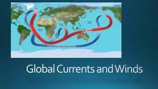
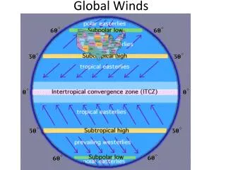
General Circulation of the Earth’s Atmosphere Deflection is least at the equator and greatest at the poles
In Northern hemisphere – cyclones spiral counter clockwise • Anticyclones spiral clockwise • In Southern hemisphere – opposite • Cyclones spiral clockwise • Anticyclones spiral counter clockwise
But heat is transported from the Equator to the Poles - how? Cold High Pressure Warm Low Pressure EARTH SUN
Warm air rises and flows polewards LOW PRESSURE L So, around the equator = (ITCZ) Inter-Tropical Convergence Zone = low pressure because solar heating
Samuel Taylor Coleridge “The Rime of the Ancient Mariner” “Down dropt the breeze, the sails dropt down,'Twas sad as sad could be” “Day after day, day after day,We stuck, nor breath nor motion ;As idle as a painted shipUpon a painted ocean.” Doldrums • Intense heating causes air to rise, leading to little horizontal motion at times • Very calm conditions
Cooled air sinks at 30 degrees N&S H HIGH PRESSURE Subtropical High
Trade winds are predictable • North East in Northern hemisphere • South East in Southern hemisphere • At subtropical high conditions are calm • known as the “horse latitudes”
Cooled air sinks at 30 degrees N&S Air flows northwards towards the Poles Some air flows back towards the Equator HIGH PRESSURE
Warm air meets cold air and rises Warmer air rises L Cold air sinks Subpolar low pressure because the warmer air of the mid-latitudes rises as it meets cold polar air
At the Poles the air is cold and dense • this produces an area of high pressure H
From the subtropical high to the subpolar low = “westerlies” • Includes variable low and high pressure systems • At the Polar Front - storms form • From the Polar High to the subpolar low are the Polar easterlies - variable
Hadley Cells
Monsoons -January high pressure over the land produces dry winds. -Air flows towards the ITCZ.
Monsoons • July - position of the ITCZ moves North • Low pressure over the land causes winds to flow off the ocean. • This brings heavy rainfall.
Permanent area of high pressure over Antarctica Seasonal pressure changes over the Arctic
Upper Atmosphere • At 5-7 kms above the surface • Influenced only by pressure gradient force and Coriolis force • Geostrophic winds that flow parallel to isobars
-Smooth westward flow of upper air westerlies -Develop at the polar front, and form convoluted waves eventually pinch off -Primary mechanism for poleward heat transfer -Pools of cool air create areas of low pressure Rossby Waves
Jet Streams • Narrow bands of high velocity • Form along the polar front and above the Hadley cell in the subtropics
Circulation patterns (CURRENTS) produced by: • Winds • Density differences in sea water • Coriolis force • Shape of ocean basins • Astronomical factors (TIDES)
Ocean Temperatures • Surface warms – especially in the summer • Layer of rapid temperature drop - thermocline
Ocean Currents wind • Driven mostly by wind blowing over the surface • However, currents move slowly • Lag behind wind speed so often called drifts
Ocean currents • Large continuously moving loops (gyres) • Produced by winds, Coriolis force and land masses
Gyres • Large circular currents • Subtropical gyre corresponds to the subtropical high pressure
N. and S. Equatorial currents corresponds to the trade winds • Equatorial countercurrent corresponds to the ITCZ
West winds around Antarctica create circumpolar gyre • Portions branch off toward the equator
Deep-sea currents • Driven by differences in temperature and salinity • Much slower than surface currents • Thermohaline circulation • Depends on conditions in the North Atlantic
El Nino/Southern Oscillation (ENSO) • Every year warming occurs off the coast of Peru (~2˚/C) • Suppresses upwelling • But every 4 or 5 years it is much more pronounced = El Nino • Because there is no upwelling fish die • May have far wider effects
In normal year, low pressure dominates in Malaysia and northern Australia. In an El Niño year, low pressure moves east to the central part of the western Pacific