Download
1 / 1
10 likes | 157 Views
New Tropical Cyclone Intensity Forecast Tools for the Western North Pacific. Mark DeMaria and John A. Knaff - NOAA/NESDIS/RAMMB, Fort Collins, CO Charles Sampson - NRLMRY, Monterey, CA Andrea B. Schumacher - CIRA/Colorado State University, Fort Collins, CO.

E N D
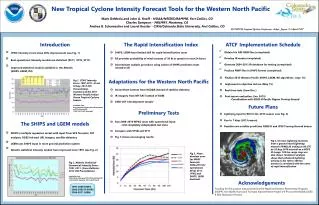
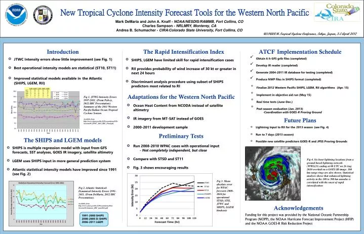
New Tropical Cyclone Intensity Forecast Tools for the Western North Pacific Mark DeMaria and John A. Knaff - NOAA/NESDIS/RAMMB, Fort Collins, CO Charles Sampson - NRLMRY, Monterey, CA Andrea B. Schumacher - CIRA/Colorado State University, Fort Collins, CO USPACOM Tropical Cyclone Conference, Tokyo, Japan, 3-5 April 2012 Introduction The Rapid Intensification Index ATCFImplementation Schedule • Obtain 6-h GFS grib files (completed) • Develop IR reader (completed) • Generate 2004-2011 IR database for testing (completed) • Produce NWP files in SHIPS format (completed) • Finalize 2012 Western Pacific SHIPS, LGEM, RII algorithms (Apr. 15) • Implement in objective aid run (May 15) • Real time tests (June-Dec.) • Post season evaluation (Jan. 2013) • -Coordination with GOES-R Proving Ground JTWC Intensity errors show little improvement (see Fig. 1) Best operational intensity models are statistical (ST10, ST11) Improved statistical models available inthe Atlantic (SHIPS, LGEM, RII) SHIPS, LGEM have limited skill for rapid intensification cases RII provides probability of wind increase of 30 kt or greater in next 24 hours Discriminant analysis procedure using subset of SHIPS predictors most related to RI Adaptations for the Western North Pacific Fig 1. JTWG Intensity Errors 1987-2011. (From Falvey, 2012 IHC Presentation). Summary of the 2011 Western Pacific/Indian Ocean Tropical Cyclone Season. Available from http://www.ofcm.gov/ihc12/Presentations/01b-Session/05-JTWC_2012_IHC_Final.pdf Ocean Heat Content from NCODA instead of satellite altimetry IR imagery from MT-SAT instead of GOES 2000-2011 development sample Future Plans Lightning input to RII for the2013 season(see Fig. 4) Run to 7 days (2013 season) Possible new satellite predictors GOES-R and JPSS Proving Grounds Preliminary Tests The SHIPS and LGEM models Run 2008-2010 WPAC cases with operational input - Not completely independent, but close Compare with STSD and ST11 Fig. 3 shows encouraging results SHIPS is multiple regression model with input from GFS forecasts, SST analyses, GOES IR imagery, satellite altimetry LGEM uses SHIPS input in more general prediction system Atlantic statistical intensity models have improved since 1991 (see Fig. 2) Fig 4. Six hour lightning locations from a ground based lightning network (WWLLN) ending at 00 UTC on 26 Aug 2010 overlaid on a GOES IR image. 100 km range rings are also shown. Statistical analysis shows that enhanced lightning activity in the 100 to 300 km annulus is correlated with the onset of rapid intensification Fig 3. Mean absolute error for WPAC forecasts 2008-2010 for operational STSD, STII, JTWC and SHIPS, LGEM hindcasts Fig 2. Atlantic Statistical-Dynamical Intensity Errors 1991-2011. (From DeMaria, 2012 IHC Presentation). Available from http://www.ofcm.gov/ihc12/Presentations/02a-Session/02-demaria_IHC_mar2012.pdf Acknowledgements Funding for this project was provided by the National Oceanic Partnership Program (NOPP), the NOAA Hurricane Forecast Improvement Project (HFIP) and the NOAA GOES-R Risk Reduction Project 1991-2000 SHIPS 2000-2005 D-SHIPS 2006-2011 LGEM