Download
1 / 15
150 likes | 249 Views
Join the Jan. 27, 2011, Winter Planning Meeting at the DNR's Division of Ecological and Water Resources. Explore historical data on high water levels in Fargo and snow depth rankings in Caledonia and Marshall. View current snow depth maps and historical images of snow-related events. Access valuable insights to aid in winter preparedness and planning.

E N D
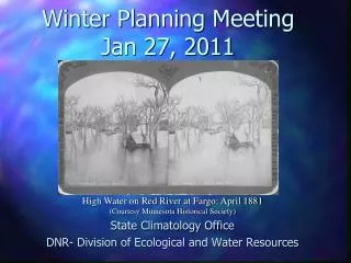
Winter Planning MeetingJan 27, 2011 State Climatology Office DNR- Division of Ecological and Water Resources High Water on Red River at Fargo: April 1881 (Courtesy Minnesota Historical Society)
80% 1 in 5 95% 1 in 20 99% 1 in 50
Current snow depth and Ranking Maps Snow depth map for January 27 http://climate.umn.edu/doc/snowmap/snowmap_110127.htm (Or Google: Minnesota Snow Depth) Shoveling out power poles near Willmar March 17, 1965 (Courtesy Minnesota Historical Society)
Any Questions? View of St. Paul: April 13, 1965 (Courtesy Minnesota Historical Society)