1 / 2

等高线地形图的基本特征

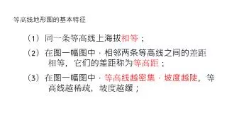
等高线地形图的基本特征. ( 1 )同一条等高线上海拔 相等 ;. ( 2 ) 在图一幅图中,相邻两条等高线之间的 差距 相等 ,它们的差距称为 等高距 ;. ( 3 )在图一幅图中, 等高线越密集,坡度越陡 , 等 高线 越稀疏,坡度越 缓;. 读 等高线地形图,完成下列题目: ( 1 ) 图 中 A 处的海拔高度为 米 ( 2 )图 中 D 处的海拔高度为 米 ( 3 )若 有登山爱好者试图登上山顶 B ,现有 L1 、 L2 两条线 供 选择 ,更加省力的是 线路。. 500. 100. L2.

haley-frost
Download Presentation

等高线地形图的基本特征

An Image/Link below is provided (as is) to download presentation Download Policy: Content on the Website is provided to you AS IS for your information and personal use and may not be sold / licensed / shared on other websites without getting consent from its author. Content is provided to you AS IS for your information and personal use only. Download presentation by click this link. While downloading, if for some reason you are not able to download a presentation, the publisher may have deleted the file from their server. During download, if you can't get a presentation, the file might be deleted by the publisher.

E N D

Presentation Transcript


  1. 等高线地形图的基本特征 (1)同一条等高线上海拔相等; (2)在图一幅图中,相邻两条等高线之间的差距 相等,它们的差距称为等高距; (3)在图一幅图中,等高线越密集,坡度越陡,等 高线越稀疏,坡度越缓;

  2. 读等高线地形图,完成下列题目: • (1)图中A处的海拔高度为米 • (2)图中D处的海拔高度为米 • (3)若有登山爱好者试图登上山顶B,现有L1、L2两条线供 • 选择,更加省力的是线路。 500 100 L2

More Related