Download
1 / 21
210 likes | 404 Views
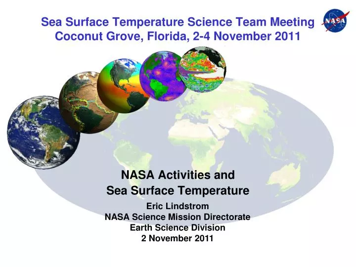
Sea Surface Temperature Science Team Meeting Coconut Grove, Florida, 2-4 November 2011. NASA Activities and Sea Surface Temperature. Eric Lindstrom NASA Science Mission Directorate Earth Science Division 2 November 2011. Outline.

E N D
Sea Surface Temperature Science Team MeetingCoconut Grove, Florida, 2-4 November 2011 NASA Activities and Sea Surface Temperature Eric Lindstrom NASA Science Mission Directorate Earth Science Division 2 November 2011
Outline • Background - Physical Oceanography Program and SST Science Team • Current Events – Opportunities • History and Future Development • Discussion Questions Eric Lindstrom NASA SST Science Team, Miami
Physical Oceanography Program Science Teams(Organized around a measurement/parameter rather than around a mission.) m • Ocean Surface Topography (ROSES 11) • Joint/CNES • Project Scientists (Josh Willis/Juliette Lambin) • Ocean Vector Winds (2010) • International (2009) • NASA Project Scientist (Ernesto Rodriguez) • NASA Team Leader (Mark Bourassa, FSU) • Ocean Salinity (2009, Phase 2- 2011) • Part of Joint NASA/CONAE Aquarius/SAC-D ScienceTeam • Project Scientists (Gary Lagerloef/Sandra Torrusio) • Sea Surface Temperature (2010) • First SST ST Meeting 11/2010 • Team Leader (Peter Cornillon, URI Andy Jessup, UW in 2012) Eric Lindstrom NASA SST Science Team, Miami
Physical Oceanography Program Support • Physical Oceanography R&A (incl. NOPP) [~$10M] • Proposals due end of June/Guidance mainly by US CLIVAR • Ocean Surface Topography Science Team [~$6.5M] • Proposals due end of October/Guidance unchanged • SWOT SDT development in coming year [~$2M] • Ocean Vector Winds Science Team [~$4.5M] • Team recently selected/May need to reshape work to meet new demands • Sea Surface Salinity Science Team [~$2M~$5M] • Phase-2 proposals (doubling team) selected after Aquarius launch • Division Pools (IDS, EOS, USPI) (SST) [~$2-5M] • Ocean-Ice Shelf interaction may be next growth area • Total annual support ~$30M/yr for ~150 Projects Eric Lindstrom NASA SST Science Team, Miami
NASA SST-Science Team • Many funding routes to membership. • Scientists contributing to the previous activities are SST-ST members. • ISST-ST meeting in November 2009; • Follow-on work produced a WHITE PAPER; • First SST-ST meeting was held in November 2010. • A basis for recent activity over the past two years has been the WHITE PAPER, • produced by the Interim Sea Surface Temperature Science Team (ISSTST) • In June 2010. • The white paper addressed three areas: • requirements placed on satellite derived SST products; • a framework for the characterization of the error budget for • satellite-derived SST products; and • recommendations for tasks that need to be undertaken to • improve satellite-derived SST products. Eric Lindstrom, NASA SST Science Team, Miami
What has NASA folded into the SST-ST • Supporting new missions: planning, preparation, implementation (example- NPP/VIIRS); • Ongoing missions: calibration, validation, bias removal, optimization, noise • characterization >>>(examples- MODIS on T&oA, WindSAT, etc.); • Product generation and improvement; • Product management and delivery: PODAAC, GDAC; • NOPP interagency support of MISST; • PO funding for research and applications: significant use of SST data/products. • All the above are part of current NASA SST Science Team activities. • PO and NOPP current NASA funding-: • ~16 projects, $3m/year (funding is comparable to other Science Teams). Eric Lindstrom, NASA SST Science Team, Miami
Aquarius Launch, 10 June 2011 Photo Credit: (NASA/Bill Ingalls) The Aquarius instrument will map the salinity at the ocean surface, information critical to improving our understanding of two major components of Earth's climate system: the water cycle and ocean circulation. Eric LindstromNASA SST Science Team, Miami
SPURS 2012 Field Campaign Science Question: What is controlling the upper ocean salinity? This question is addressed with measurements from satellites, ships, drifting surface buoys & profiling floats, gliders, AUVs and theoretical & numerical model simulations. Motivation The launch of the Aquarius/SAC-D satellite motivates plans for a field campaign in the salinity maximum region of the North Atlantic. Sea Surface Salinity Planning • Community workshop in December 2009 • Workshop report published on the SPURS web site: http://spurs.jpl.nasa.gov • Interagency/international collaborations being established • Call for proposals in ROSES 2010 • SPURS come in pairs; next in region with high precip.
Profiling Float Measurements of Wind Speed, Rainfall, and Near-Surface Temperature and Salinity S. Riser, University of Washington Depths < 3 meters samples at 5 cm intervals SBE-41CP CTD SBE STS SeaBird surface temperature/salinity sensor (STS) (250 profiles) [ T 0.005 C; S 0.05 PSU ]
T S 6/24/2009 - 7/15/2009 fast cycle sampling Upper 5 m; t 2 hr; 0-150 m T and Snear the surface relative to values at 15 dbar (Iridium communications allow mission parameters to be adjusted remotely)
NPP Launch 28 October 2011 Eric LindstromNASA SST Science Team, Miami
NPOESS Preparatory Project • The NPOESS Preparatory Project (NPP) will serve as a bridge between NASA’s current Earth Observing System (EOS) satellites and the forthcoming series of Joint Polar Satellite System (JPSS) satellites to: • extend key measurements to support monitoring of climate trends and global biological productivity; • extend the measurement series initiated with EOS Terra and AQUA (a bridge to JPSS [NPOESS]); • provide operational agencies early access to the next generation of operational sensors; • permit testing of the advanced ground operations facilities and validation of sensors and algorithm while the current operational systems are still in place; • The five-instrument suite includes: the Visible/Infrared Imager Radiometer Suite (VIIRS); the Cross-track Infrared Sounder (CrIS); the Clouds and Earth Radiant Energy System (CERES); the Advanced Technology Microwave Sounder (ATMS); and the Ozone Mapping and Profiler Suite (OMPS). • Sensors will collect data on atmospheric and sea surface temperatures, humidity soundings, land and ocean biological productivity, and cloud and aerosol properties. Data will be used for long-term climate and global change studies. • NASA SST-ST supports work focusing on establishing and validating the CDR quality of VIIRS SST. Eric Lindstrom NASA SST Science Team, Miami
History and What’s New • ISST-ST meeting in November 2009, URI, RI; • Follow-on work produced a WHITE PAPERon 18 June 2010; • First SST-ST meeting was held in November 2010, Seattle, WA; • Joint DVWG/HL-TAG/ST-VAL Workshop, February/March 2011, Boulder, CO; • Aquarius Launch, 10 June 2011 (provides new opportunities); • GHRSST Meeting, June 2011, Edinburgh, UK (CEOS proposal); • NPP-VIIRS Launch, 28 October 2011 (provides new opportunities); • 25th CEOS Plenary, 8-9 November 2011, Lucca, Italy (Freilich assumes SIT Chair & GHRSST becomes Virtual Constellation in CEOS). Eric Lindstrom, NASA SST Science Team, Miami
Perspectives, Issues, Discussion How to interface with Ocean Salinity Science Team/Aquarius, especially with regard to surface layer dynamics (requiring density and SSS info, not just SST)? Recognition that many multi-sensor activities are ongoing to optimize the utility of individual parameters (a broader arena of Climate Data Records). Is it time to redefine NASA/Science Team relationship to GHRSST? How best to make the most of the commonalities/complementarity? Eric Lindstrom, NASA SST Science Team, Miami
How Science Team Members can help NASA (and GHRSST) • Deliver scientific breakthroughs and well-cited publications. • Keep NASA and the rest of the Science Team informed of scientific breakthroughs and publications. • Actively attend and support Science Team meetings. • Respond as needed to requests from the Team Leader for scientific and technical input. • Enhance Interagency and international coordination. Eric Lindstrom, NASA SST Science Team, Miami
ROSES 2011(Research Opportunities in Space and Earth Sciences) • Research not Product Generation • Two research themes are identified. • Analysis and interpretation of the ocean circulation using satellite and in situ data. • Expoitation of sea surface temperature products. • NASA is playing a central role in providing the next generation • of data products for sea surface temperature through the Group • on High-Resolution Sea surface Temperature (GHRSST). • Proposal are sought which utilize or exploit these data products • for innovative physical oceanography science. • This opportunity is NOT for development or improvement of data products. • $2.0 million/year for three years • 10-15 awards Eric Lindstrom, NASA SST Science Team, Miami
NASA SUPPORT OF GHRSST: GDAC/RDAC GLOBAL DATA ASEMBLY CENTER (GDAC) and REGIONAL DATA ASSEMBLY Center (RDAC) Activities Main Data Clearinghouse for all GHRSST Data Streams. Provides rolling archive (30 days) for all GHRSST L2P data streams. GHRSST data streams managed under the Data Management and Archive System (DMAS) of the PO.DAAC. L4 Data Streams also archived at GDAC. Provide user support through PO.DAAC User Services. After 30 days data goes to Long Term Stewardship and Reanalysis Facility (LTSRF) at NOAA/NODC. Edward Armstrong acting chair of the Data Assembly and Systems Technical Advisory group (DAS-TAG). Jorge Vazquez acting chair of the Applications and user Services Technical Advisory group (AUS-TAG). Other related activities include archiving of L3 products, serve as RDAC (in collaboration with University of Miami and Ocean Biology Processing Group) for MODIS L2P data, fill ancillary fields (wind speed, etc.) and maintain MMR (master metadata repository). Maintain tools and services in support of GHRSST, including, L2 subsetter, “State of the Ocean”, and POET for Level 4 data subsetting.
WindSAT multi-parameter effort at RSS • SST, wind speed (several), water vapor (several), rain, wind direction. • Current data 2003-2010. • Team is catching up to NRT data production & should begin NRT by July 2011. • Products include SST compared to GTS buoy network data. Eric Lindstrom, NASA SST Science Team, Miami
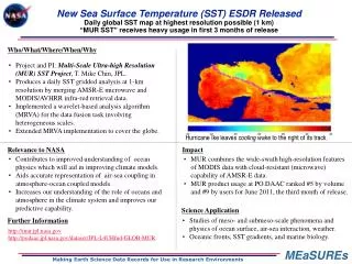
SST support under MEaSUREs program • Making Earth Science Data Records for Use in Research Environments (MEaSUREs) program (typical funding period 2008-2013) supports production of consistent (e.g., long-term) Earth science data records, including SST data products. • GAC and HRPT AVHRR Reprocessing Project (P. Cornillon, R. Evans, K. Casey) develops a 28 year (1982-2010) global SST data set at full GAC resolution (4km) and regional SST data sets at full HPRT resolution (1km) made available in GHRSST L2P format. • Multi-scale Ultra-high Resolution (MUR) SST (T.M. Chin, J. Vazquez, E. Armstrong, A. Mariano) is a daily 1km-resolution global SST field produced in GHRSST L4 format using multi-resolution and motion-compensated analysis techniques. Eric Lindstrom, NASA SST Science Team, Miami
NOPP Partnerships (Interagency Funding) NOPP Partnership for Skin SST Award for the coordinated use of skin SST in satellite validation, including the TRMM (Tropical Rainfall Measuring Mission) Microwave Radiometer (TMI), and the Advanced Microwave Scanning Radiometer for the Earth Observing System (AMSR-E) on Aqua. NOPP – Multi-sensor Improved SST (MISST) Project Coordinated US contribution to the international Group for High-Resolution Sea-Surface Temperature project (Gentemann, C. L. et al., 2009). The project has produced satellite SST data from nine satellites in an identical format with ancillary information and estimates of measurement error. Use of these data in global SST analyses has been improved through research into modeling of the ocean surface skin layer and upper ocean diurnal heating. These data and research results have been used by several groups within MISST to produce high-resolution global maps of SSTs, which have been shown to improve tropical cyclone prediction. Additionally, the new SSTs are now used operationally for marine weather warnings. Already competed and selected. Implementation of multi-agency funding is ongoing. Eric Lindstrom, NASA SST Science Team, Miami