Ch. 8 Key Issue 2
Ch. 8 Key Issue 2. Why Do Boundaries Between States Cause Problems?. http ://www.thedailyshow.com/watch/wed-september-4-2013/sir-archibald-mapsalot-iii. Geographic Characteristics of States**.

Ch. 8 Key Issue 2
E N D
Presentation Transcript
Ch. 8 Key Issue 2 Why Do Boundaries Between States Cause Problems?
http://www.thedailyshow.com/watch/wed-september-4-2013/sir-archibald-mapsalot-iiihttp://www.thedailyshow.com/watch/wed-september-4-2013/sir-archibald-mapsalot-iii
Geographic Characteristics of States** • Size – larger countries may have more possibilities available to them as far as carrying capacity • Climate variety & agriculture; Resources available • Determines type of government? • Shape – can foster or hinder effective organization of the state. • Location – relative and absolute • Landlocked – very disadvantageous relative location • Cores and Capitals– Core area is the nucleus from which a state grew and developed – usually contains the capital city.
State Shapes • Compact • Efficient communication and transportation • Elongated • Bad communication, isolation from capital • Prorupted (interrupted)- created for 2 reasons: • Access to resource • Separate 2 states from having common boundary
State Shapes • Perforated • The surrounding state; states within become depended upon this state and are known as enclaves (Lesotho/South Africa) • Fragmented • Problems with internal communication • 2 types • Separated by water • Separated by another (intervening) state
Exclave Vs Enclave • Exclave – a territorial outlier of one state is surrounded by the territory of another state • Bangladesh • Enclave – a piece of territory surrounded by a country which is not ruled by that country (may be an exclave of another country) • Lesotho, Andorra
shapes Enclave
Exclaves – May be difficult to maintain or to protect themselves from being taken over by the country which surrounds them.
Landlocked States • Completely surrounded by land - more a condition than a shape • Problematic for international trade because they lack direct access to the ocean • Most common in Africa • Colonial era • Railroads- Creates cooperation or friction between states
Notice how each colonial power (UK, France, etc.) has access to ports/oceans. What happens when the colonial powers leave and these countries become independent?
Motivation for Iraq’s Invasion of Kuwait –1. Dispute of withdrawals from the oil field2. Claim of Pre-British ownership3. Desire for better access to the Persian Gulf Terrible Much Better
Types of Boundaries • Boundary- the invisible line separating states • Source of conflict when not agreed upon • Physical - easily seen • Desert (Af., Asia), Mountains (Andes, Pyrenees) = hard to cross • Water (E. Af.) – where does territory end? • Law of Sea (UNC[onvention]LOS)- see next slide • 158 countries accept = standardized laws • Rio Grande
Literally invisible! Imagine the conflicts that can arise over where one border ends and the other begins! However, these countries are part of the European Union, which allows easier border crossings
Types of Boundaries • Cultural: problematic rarely divide individuals perfectly (artificial) • Geometric • Most common; straight line- US and Canada • Religious • Separation of Pakistan from India; Northern Ireland; Israel/Palestine? • Language • Versailles Peace Conference after WWI • Drawn around language speakers (creation of Yugoslavia)
Types of Geometric (Artificial) Boundaries • Antecedent – drawn before area populated Subsequent – after settlement • Consequent – drawn to accommodate differences • Superimposed – forced upon the cultural landscape (1948 – Israel, Africa- Berlin Conference 1884-5) • Relic – no longer functions but still marks a transition • Great Wall of China, Hadrian’s Wall, Berlin Wall
Frontiers • Used to separate states, no contact • Tangible geographic area rather than thin imaginary line • Uninhabited or sparsely populated • Becoming less prominent
Boundaries Inside States • Local boundaries drawn for separation or for political reasons • Counties, cities, voting districts • State gov’t restructured to give more power to local gov’t • Appeases minority ethnicity; may give regional autonomy
Unitary vs Federal • Unitary- strong central gov’t. • Compact states • Federal- strong local gov’ts. • Large states where regions may be isolated from capital • Rule breakers • Belgium and China– WHY?
Nigeria’s Federal Government – Allows States within the country to determine whether to have Shari’aLaw (Islamic Front) Shari’aLaws- Legal systems based on traditional Islamic laws of Qur'an
The U.S. Federal Government – Allows States within the state to determine laws such as death penalty, access to alcohol, and concealed weapons. Minnesota’s concealed weapons law requires the posting of signs such as this on buildings that do not allow concealed weapons.
Boundary Disputes*** • Position disputes – disagree to interpretation of the boundary treaty – Chile/Argentina in S. Andes • Territorial disputes – over ownership of territory • Irredentism – land that was formerly part of another state with which there are ethnic ties • Resource disputes – Kuwait & Iraq • Functional disputes – disagreement over policies to apply to border – Mexico & U.S.A.
Electoral Geography • Boundaries created w/in US to give equal population in voting districts • Redrawn every 10 years with the census • Gerrymandering: redrawing voting districts to give a party an advantage • Stacked vote: links same voters w/ oddly shaped boundaries most used
Nationalism: a double-edged sword • Nationalism can bring a people together and provide a strong centripetal forceholding the country together. • Nationalism, particularly when carried to extremes, can be a divisive, centrifugal forceworking to tear a country apart when it is exercised in a multi-national state. • DEVOLUTION
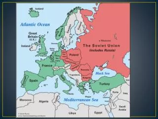
Centripetal Forces: Pull Together*** • Nationalism • Primarily one language in common use • Unifying Institutions – common religion, etc. • Organization & Admin. – evolve from national core • Unitary state • Federal state • Transportation & Communication – connect • Railroads in the U.S. • Trans-Siberian RR in the Russia/Soviet Union
Centrifugal Forces: Disrupt*** • Multi-nationalism – Canada, Bosnia, Afghanistan • Incompatible religions – partition of India in 1947 – still in conflict with Pakistan over Kashmir region • Multiple languages in use • Very strong regional differences (cultural and/or economic) – i.e. led to US Civil War • Artificial creation – not evolving from a national core • Particularly true of most of the former colonies which became the countries of modern Africa • Irredentism • Insurgent groups operating within the country
Devolution • Movement of power from central government to regional governments within the state • Caused by three forces • Ethnocultural • Division due to distinct culture within state • Economic • Battle between core and periphery regions w/in the state • Territorial • Most devolution occurs on boarders of states or in isolation from capital (Hawai’i)
Britain has granted Scotland its own parliament and Wales may follow. Sometimes granting greater autonomy can stave off a full scale revolt and independence.
Disputes for regional autonomy • Separatism • Canada’s secessionist movement in Quebec: 1995 referendum 49% yes, 51% no. • Other separatist movements: • Basques in Spain; • Bretons in France, • Palestinians in Israel, • Sikhs in India, etc.