
Uploaded by
gudrun
5 SLIDES
239 VIEWS
50LIKES
River Alyn
DESCRIPTION
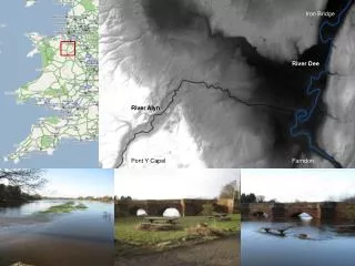
Iron Bridge. River Dee. River Alyn. Pont Y Capel. Farndon. ERS-2 Image – River Dee Flood, December 2006. Data extraction methods from satellite image for assessing model performance. Calibration of LISFLOOD-FP model using remotely sensed data. Measure of Fit (%). RMSE (All points).
Download
1 / 5
Download Presentation 
River Alyn
An Image/Link below is provided (as is) to download presentation
Download Policy: Content on the Website is provided to you AS IS for your information and personal use and may not be sold / licensed / shared on other websites without getting consent from its author.
Content is provided to you AS IS for your information and personal use only.
Download presentation by click this link.
While downloading, if for some reason you are not able to download a presentation, the publisher may have deleted the file from their server.
During download, if you can't get a presentation, the file might be deleted by the publisher.
E N D
Presentation Transcript
Iron Bridge River Dee River Alyn Pont Y Capel Farndon
Data extraction methods from satellite image for assessing model performance
Calibration of LISFLOOD-FP model using remotely sensed data Measure of Fit (%) RMSE (All points)
Calibration of LISFLOOD-FP model using remotely sensed data RMSE (‘Robust’) Mean of 100 combinations of 50 points that together have no spatial dependency Tested using Moran’s I


More Related
Audio
Live Player