Download
1 / 21
210 likes | 224 Views
This experiment involves P-3 flights from Thule and Kangerdlussuaq to acquire data using 150 MHz and 450 MHz radars. The objectives include comparing observations at different altitudes, backscatter and interferometric frequency response, detection of subglacial water, implementation of interferogram phase filtering, tomographic analysis, repeat pass interferometry, verification of weak volume clutter, and testing for absorption effects in thick and thin ice.

E N D
September 07 Experiment • P-3 flights from Thule and Kangerdlussuaq • 150 MHz and 450 MHz Radars • Maximum altitude allowable • Experiment Plan Posted at • http://www-bprc.mps.ohio-state.edu/rsl/gismo/documents/GISMO_07.pdf
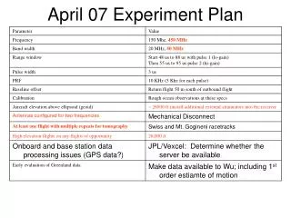
Technical Objectives for September ’07 Experiment • 1) Acquire data over the May 2006 flight line to compare high and low altitude observations and to compare interferometry acquired with different baselines. Are results consistent with theory? • 2) Acquire data at 150 MHz and 450 MHz along every flight line and compare backscatter and interferometric frequency response? Are the results consistent with theory? • 3) Acquire data over areas where we expect to find subglacial water. Is water detectable either from backscatter maps or from topography? • 4) Acquire data over regions of increasing surface roughness. This may require observations over heavily crevassed shear margins such as those found around Jacobshavn Glacier. Can we successfully implement interferogram phase filtering? • 5) Acquire data for tomographic analysis • 6) Investigate repeat pass interferometry over repeat periods of days. • 7) Verify volume clutter is weak (all snow zones) • 8) Collect data over thick and thin ice to test for absorption effects
Constraints on Flight Operations • Fly at maximum allowable altitude • Limit flight duration to allow for daily data Q/A and experiment modifications (about 6 hours assuming 150 Gb/hour and 3, 300 Gb disks) • Allow enough field time to repeat flight lines • Fly over high and low clutter areas • Fly over areas where some information on basal properties is known • VHF and UHF radars cannot operate simultaneously – repeat P-band and VHF along same track to within 30 m • Schedule 2 to 4 repeat flights at 30 m horizontal offsets for tomography
Proposed Flight Lines • Ice Streams • Outlet Glaciers • Jacobshavn • OSU Clusters
Jacobshavn • Open Ocean Segment down Sondrestrom Fjord • Several passes over Jacobshavn glacier with tomography racetrack • Flight over GRIP GISP drill sites • Outbound at 26000 ft, Return flight at 500 feet • Flights at 150 MHz and 450 MHz
Thule 2 Flight of NEMES drilling site location Flights across crevassed areas of outlet glaciers and across grounding lines Tomography racetrack over Mt. Gogineni Segment over open ocean Flight at 150 and 450 MHz
Thule Flight 1 • Flight 1 • Segment over open ocean • Repeat segment flown at 150 MHz in May 2006 • Flights at 150 and 450 MHz • Overflight of NGRIP and North East Ice Stream
Clusters • Measurements where 2-dimensional surveys have been conducted: • OSU Clusters • Dye 3 • Measurements over East Greenland outlet glaciers
Range Window Duration (Clusters) 1500’ elevation over ice sheet 26000’ Presssure Altitude
August 07 Test Flights and Transit
Test Flights • Plan one test flight with at least one contingency flight • Data collection to be beyond 200 mile limit • Data collection portion of flight to last 2 hours • Antennas configured at 450 MHz (operate radar at 450 and 150 by utilizing harmonic)
Test Flight Objectives • Verify that the radar system reliably transmits/receives/records data at 450 and 150 MHz. • Verify and practice operational procedures including procedures for turning on and turning off the radar in concert with aircraft crew manipulation of aircraft power.
Test Flight Approach • Conduct 1, 2 hour data collection test flight (allow for one contingency flight) • Record ocean waveforms and verify consistent, uninterrupted data acquitision. • Verify chirp shape and duration. • Verify loop sensitivity • Verify system bandwidth • Verify presum rates • Verify GPS data stream link • Conduct two +-60 degree rolls to acquire antenna pattern data. • Transfer test data to KCJ disk and process data. • Label all cables. Calibration Tests????? • Test contingency plans (several options in case of a primary radar failure?).
Test Flight Success Criteria • Radar transmits receives and records uninterrupted data over the designed bandwidths at 150 and 450 MHz. • Data are downloadable and processable. • Tools necessary for calibration (eg load terminators) are available. • Procedure pages are available for the operator and vetted
Go/No Go Decisions for Discussion • What do we do if we observe intermittent or more serious failures? • What do we do if there is another catastrophic failure? • Do we address problems in the plane? • Do we immediately dismantle and put the radar box on a bench at WFF (adequate room to easily pull radar box)? • Do we ship back to Lawrence?
Transit • Transit to Thule with 450 MHz antennas • Do first Thule flight for GISMO to secure some data early • Interleave remaining flights with ATM/MCARD on subsequent flights noting that it would be useful to complete 450 MHz flights before changing to 150 MHz antennas • Transit to Sonde at 150 MHz • Complete ATM/MCARD and 150 MHz GISMO flights • Complete 450 MHz GISMO flights • Return transit at 450 MHz for additional calibration work