Urban History and Education Policy: A Seminar for Junior Thesis Students
200 likes | 317 Views
Join us for an engaging research seminar focused on urban history and education policy, led by experts Andy Anderson (Academic Technology Services) and Hilary Moss (Departments of Black Studies & History) at Amherst College. This seminar is designed for juniors considering potential thesis projects, exploring topics such as de jure and de facto segregation, urban renewal, and the impact of place on educational opportunities. Collaborative methodologies including archival analysis, oral interviews, and GIS will be incorporated. Don't miss the chance to shape insightful research on education and urban dynamics!

Urban History and Education Policy: A Seminar for Junior Thesis Students
E N D
Presentation Transcript
Cities, Schools, and Space • Andy Anderson (Academic Technology Services) • Hilary Moss (Departments of Black Studies & History) • Amherst College • A research seminar for juniors • Urban history and education policy • Potential thesis students encouraged! Northeast Arc Users Group Spring Conference — Smith College 5/17/2011
Many Research Methodologies Archival analysis Oral interviews GIS: integrated into the course
Students and parent atTobin School, Cambridge Web Page (Restricted)
In America, a child’s address,more than any other factor, often determineswhat kind of public educationhe or she will receive. Black School in Louisa County, Virginia, ca. 1935(LOC/NAACP) Cambridge, Massachusetts Latin School, 1916 (CHLS Yearbook)
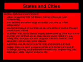
De Jure Segregation • Legal segregation of public schools by race banned nationwide in 1954 — separate, not equal • Unequal educational opportunities still exist for a variety of reasons
De Facto Segregation • Federal policies that expanded suburbs and facilitated “white flight” and job loss: • Mortgage assistance • Investment depreciation • Highway construction • Public housing • Urban renewal
Disguised Segregation • Subtle school segregation can still exist: • Shifting school catchment areas • Building new schools in white/upper-class areasat the expense of existing facilities • Educational tracking of students
Cambridge, Massachusetts Cambridge Public Library • A progressive city of 110,000 people • Black and Hispanicpopulations substantially increased in the late 20th century • 1965: Schools already racially imbalanced
Learning GIS: Basic Skills • How does Cambridge compare to nearbycommunities? • Census.gov1990 - 2010 • NHGIS.org≤ 1980
Extracting Map Features • Interstate 695: The “Inner Belt”through eastCambridge • 1967 map ofproperties affected • Stopped in 1971
What Influences Urban Renewal? • Union • Dissolve • Area Calc
Possible Inputs to Urban Renewal Negro Population 1960 • Data from the 1960 census: • Older Housing (Before 1940) • Housing Value • Owner-Occupied Housing • Negro Population • Data requirements: • Not cross-correlated: use Excel’s CORREL • Spatially auto-correlated: use ArcGIS’ Moran’s I
What Influenced School Building? • One of the eight student projects • Six new or reconstructed schools • Worst school, Fletcher, untouched
What Influenced School Building? • Parcel Analysis • Distribute censusinfo by housing type on parcels
Thanks! • Cambridge GIS! Jeff Amero, et al. • Cambridge Assessor • Cambridge Historical Society • MIT Archives • National Historical GIS @ U. Minn