Download
1 / 2
20 likes | 116 Views
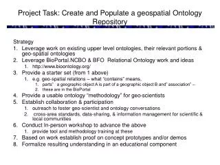
This project aims to create and populate a geospatial ontology repository strategy, leveraging existing upper-level ontologies and BioPortal NCBO resources. The goal is to provide a usable ontology methodology for geo-scientists, establish collaboration and conduct workshops for advancing geo-scientist conversations. The focus is on cross-area standards, data-sharing, proof of concept prototypes, and educational components. Discussion includes handling contradictions and combining top-down and bottom-up approaches for a comprehensive ontology suite.

E N D
Project Task: Create and Populate a geospatial Ontology Repository Strategy • Leverage work on existing upper level ontologies, their relevant portions & geo-spatial ontologies • Leverage BioPortal.NCBO & BFO Relational Ontology work and ideas • http://www.bioontology.org/ • Provide a starter set (from 1 above) • e.g. geo-spatial relations – what “contains” means, • parts” a geographic object A is part of a geographic object B and” association” – • these are in the BioPortal • Provide a usable ontology “methodology” for geo-scientists • Establish collaboration & participation • outreach to foster geo-scientist and ontology conversations • cross-area standards, data-sharing, & information management for scientific & local communities • Conduct In-person workshop to advance the above • provide tool and methodology training at these • Based on work establish proof on concept prototypes and/or demos • Formalize resulting understanding in an educational component
Conclusion Dolce Ultra Lite? • Lots of important work to do. • Could take simple relations to an existing top level to cover sets, time, number abstractions etc. • Need to flesh out “Geo” top • Part is an instance of Spatial Relation etc. • What are the requirements for populating a good family of ontologies? • We want a domain modular, extensible ontology and…. • Lower parts are increasingly the work on the wider Geo-Spatial community • There may be inconsistencies between them • Can we use micro-theories to handle this? • is-true to handle possible contradictions • Can we combine top-down and bottom approaches to reach a good O-suite in the OOR? “Geo” Top “Geo”-Domain From Uses Cases & Demos?