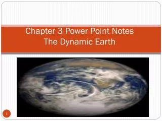
Chapter 3 The Dynamic E arth
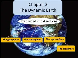
Chapter 3 The Dynamic E arth. It’s divided into 4 sections. The hydrosphere. The geosphere. The atmosphere. The biosphere. 1) Geosphere. The earth is an integrated system that consists of rocks ( geo ) , air ( atmo ) , water ( hydro ) , living organism ( biosphere ) .

Chapter 3 The Dynamic E arth
E N D
Presentation Transcript
Chapter 3The Dynamic Earth It’s divided into 4 sections The hydrosphere The geosphere The atmosphere The biosphere
1) Geosphere • The earth is an integrated system that consists of rocks ( geo ), air ( atmo ) , water ( hydro ) , living organism ( biosphere ). • So geosphere is: the solid part of the earth that consists of rocks , soils , sediments.
The composition of the geosphere • The earth’s surface is divided into several layers according to the density of materials forming these layers….they are from up to down • Earth’s crust • Mantle • Core
Earth’s crust mantle core
Earth’s crust It’s the outermost layer of the earth’s surface It’s made almost entirely of light elements Less than 1% of the planet’s mass Earth’s thinnest layer ( 5 to 8 kms thick beneath the oceans or 20 to 70 kms beneath the continents)
mantle It’s the layer beneath the crust Made up of rocks with medium density Makes up up to 64 % of the earth’s mass Approximately 2900 kms thick
core • It’s the deepest layer of the earth • Made up of rocks with high density • Its radius is equal to 3,400 kms Finally lets hear that song about the layers of earth
& here’s your assignment Draw a table classified into 3 columns for • Crust • Mantle • Core Comparing between them according to what you’ve learnt
Other scientists divided the earth into 5 layers according to the physical properties of each layer • Lithosphere: • Cool , rigid layer • 15 kms to 300 kms thick • Includes the crust & the upper part of the mantle • Divided into huge pieces called tectonic plates
Mesosphere: • Beneath the asthenosphere • Lower part of mantle • Asthenosphere: • Beneath the lithosphere • Solid layer of middle mantle • Flows very slowly, allowing the tectonic plates to move over it • Outer core: • Dense liquid layer • Due to high temperature • Inner core: • Dense solid layer • although to high temperature due to high pressure
Lets stop here today make sure you wrote your homework See you next time
Let’s warm up What happens when you put some pieces of ice in a beaker containing water Can you remember in which layer of the earth are the tectonic plates present?
The same thing happens to the tectonic plates ( present in the lithosphere ) They slide over the underlying asthenosphere so the whole continents present in those plates move
The sliding of the continents over the surface of these moving tectonic plates cause most of the geological activities at the surface of earth like: Earthquakes Volcanic eruptions erosion Mountain formation
How can they cause those geological phenomena? • When theses plates move they cause enormous forces at their boundaries by either: • Sliding away from each other ( divergent ) • Colliding with each other ( convergent ) • Slipping one past the other ( transform )
How do earthquakes occur? • A fault is a : Break in the earth’s crust along which blocks of earth’s crust slide relative to one another. • When rocks that are under stress suddenly break along a fault a series of ground vibrations are set off. • They occur all of the time but many of them are so small that we can’t feel.
How to measure the strength of the earthquake? • By the amount of energy released from the earthquake movement ,,,the measure is called Ricktarmagnitude • Smallest magnitude is (2.0) [ can’t be felt ] • Largest magnitude is ( 9.5 ) [ destructive ] • Each increase by 1 means 31.7 times more energy
Where do earthquakes occur? • It occurs mainly in the boundaries between the plate tectonics because of the enormous stresses that are generated when tectonic plates separate , collide , or slip past each other • Lets see different maps for the boundaries between plate tectonics
Volcanoes • What is a volcano ??? • It’s a mountain built from magma ( molten rocks ) that rises from the interior of the earth. • Where does it occur??? • It occurs near the boundaries of the tectonic plates as well as earthquakes. • Specially when they collide or separate from each other
Local effects of volcanic eruptions • Human loss • Volcanic ash can mix with water & produce a mudflow ( in 1985 Nevado Del Ruiz in Colombia erupted melting ice at the volcanic summit, a mudflow raced downhill & engulfed the town of Armero) • Volcanic ash falls to ground destroy buildings ,bury crops , damage car engines • Ash causes breathing difficulties
Global effects of volcanic eruptions • It can change the climate of the whole earth for several years ( how??) • The clouds of the volcanic ash & sulfur rich gases may reach the upper atmosphere reducing the amount of light & heat reaching the earth causing a drop of average global temp by several tenths of degree celesius
Erosion • Originally the rocks may be formed at the boundaries of tectonic plates • They are subjected to either wind or running water which may cause its erosion • Erosion is the removal & transport of the earth’s surface material
The more the rocks are subjected to wind or running water , the smoother these rocks will be . • This observation helped the scientists to learn that the round-topped Appalachian mountain in the eastern United States are older than the jagged Rocky Mountains in the west • Wind & running water cause erosion of coastlines to give variety of spectacular landforms. • Rivers can carve deep gorges into the landscape.