Download
1 / 10
100 likes | 126 Views
Learn innovative methods for optimizing maintenance cycles, spatial referencing, and data reporting in vegetation management. Explore automated solutions for field data collection and interactive reporting through GIS technology. Join us at the Ohio GIS Conference to revolutionize your utility mapping processes!

E N D
Connecting Field and Office: An Innovative Approach to Vegetation Management and Utility Mapping Justin Walters Geospatial Specialist – Utility Vegetation Management Project Lead Davey Resource Group Ohio GIS Conference September 25 – 27, 2017 Hyatt Regency Columbus Columbus, Ohio
The GIS Relationship to Utility Vegetation Management 1. Maintain and organize maintenance cycles2. Spatial reference to surroundings3. Optimize relationship between field and office4. Tangible evidence
1. A concise and visually appealing work order 2. Visualize generalities and specifics 3. Labeling to satisfy the needs of jurisdictions Tangible Map Production: Maps
1. Reporting specifics of planned data 2. Reporting summaries of planned data 3. Reporting billing necessities Tangible Map Production: Reports
1. Arcpy 2. Model Builder 3. Add-ins Tangible Map Production: Automations
1. Proprietary software integrating GPS and GIS 2. GPS driven, GIS visualization 3. Ease of Use and Customization Field Collection Software - Rover
1. Real time data accuracy 2. Visual, mapped archive of planned work 3. Custom selections and queuing of data Interactive Data Storage – MyROWKeeper
1. Custom Reporting 2. Interactive attributes window 3. Direct downloads Interactive Data Storage – MyROWKeeper
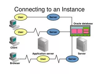
Field Planner The Relationship: Rover to MyROWKeeper MyROWKeeper Rover Rover MyROWKeeper Office Staff
Thank You! Justin Walters (330) 673-5685 ext 8164 Justin.Walters@Davey.com Geospatial Specialist – Utility Vegetation Management Project Lead Davey Resource Group Ohio GIS Conference September 25 – 27, 2017 Hyatt Regency Columbus Columbus, Ohio