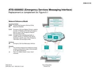
Central Valley Spatial Reference Network (CVSRN)
Central Valley Spatial Reference Network (CVSRN). Caltrans-Central Region Presenter Giana "Gigi" Cardoza, PLS Transportation Surveyor Party Chief. What is it? Concept-Project Evolution Pilot Project Planning • Site Visits / Permitting • Monument Style

Central Valley Spatial Reference Network (CVSRN)
E N D
Presentation Transcript
Central Valley Spatial Reference Network (CVSRN) Caltrans-Central Region Presenter Giana "Gigi" Cardoza, PLS Transportation Surveyor Party Chief
What is it? Concept-Project Evolution Pilot Project Planning • Site Visits / Permitting • Monument Style • Communications/Telemetry • IT • Power Supplies • Software / Equipment • Implementation/Timeline • Who will use the system? • Partnering/Information Sharing • The Big Picture • Cost Recovery • The End-Questions Presentation Outline
What is it? Central Valley Spatial Reference Network (CVSRN) The California Department of Transportation’s Central Region is moving forward with the planning and building of a scalable regional spatial network that will have Real Time Kinematic Network (RTKN) capabilities. The CVSRN will be comprised of Global Positioning System (GPS) stations that are permanently in place and operate continuously. The data from this network will be used for post processing as well as instantaneous real time processing .
Project Evolution-The Initial Idea. • Facilitating in-kind services with CSRC-Height Modernization Project. • Monument setting. • GPS Observations. • High Precision Leveling. (State Highways 152, and 198) • Involvement with various GPS Users Groups throughout the State. • Facilitating PBO in permitting sites along State Right of Way. Direct result of education and circumstances.
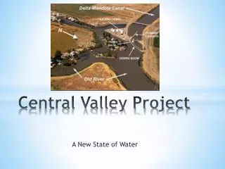
Fresno Area Real-Time Network Original Plan “FARTN”
Valley Real-time Geodetic Network Revision #1 “VRGN”
Central Valley Spatial Reference Network Pilot Project “CVSRN”
Site Visits and Permitting • Currently have 4 active PBO sites within Pilot project area. • Actively involved with the Permitting of 3 additional PBO Sites (2 of which will be part of the Pilot Project). • 5 Locations have been sited at existing Caltrans Maintenance Stations. • 1 Site has been located at the Reedley Municipal Airport - Currently in discussions on permitting. • 1 remote site location along Route 145. 13 Total Sites to be included in the Pilot Project.
Monument Style Radome Cover with SCIGN GPS Antenna Adaptor Assembly
Telemetry-Caltrans Backbone Telemetry solution -Radio and Cellular Technologies -Dedicated Internet Lines. -Ethernet Lines
Power Supply Visalia Maintenance Yard • Remote Sites - Solar Paneling with a Battery Configuration. (Similar to PBO Setups) • Caltrans Maintenance Stations: Trenching and Hardwiring. PBO- P300 Int. 5 PBO- P304 Mendota Site
Software / Equipment • Software: No Decision has been made at this time. • Software we are looking into. • Trimble RTKnet. • Geodetics Inc.- RTD / Smartclient • Leica - Spider 2 • Others? • Pilot Project Equipment to be Used. • Receivers: Trimble 5700’s • Antennas: Trimble Zephyr Geodetics • Existing PBO Stations have Trimble NETRS Receivers with choke rings (Mixture of Monument types and Equipment.)
Implementation / Timeline July-August - 2005 Physical Stations Built August-September - 2005 Leveling / Install GPS Equipment October-November - 2005 Install Telemetry December - 2005 Station Coordination January - 2006 Testing February-March - 2006 Implementation of Pilot Project. November-December – 2006 Recovered Costs of Pilot Project. Schedule Subject to Funding timelines.
Who will use the system? • Agricultural Community • Construction Industry Machine Guidance • Safety Services Police / Fire • Utility Companies • Education • Airports-Navigation • Caltrans Survey Crews • Cities / Counties Surveyors GIS Users Public Works • Local Surveyors • GIS Community
Partnering /Information Sharing Partnering • CSRC-Greg Helmer, Yehuda Bock, • PBO-Brian Coyle, Chris Walls • NGS-Marti Ikehara • Office of Land Surveys-Caltrans-Mark Turner, Dick Davis, Tom Taylor, Bill Jackson • Reedley Municipal Airport • Additional Partnering • In-House Departments • Airports • Cities • Counties Information Sharing • Orange County- Art Andrew • CSRC - Yehuda Bock, Greg Helmer, Don D’onofrio • Haselbach’s Instruments- Hans Haselbach, Jeff Surry • Trimble- Hugh Johnston, Darcy Shunk, Nathan Pugh • California Surveying and Drafting - Frank Frazer
The Big Picture... Hope to Incorporate SCIGN Stations in the South Valley Long Term Goals
Cost Recovery Savings Analysis - Initially Identified Cost Savings * Save Crew Time on Setting up Base Station and Radio at the beginning of the day and the end of the day. * No longer have a crewmember protecting base station / increase production. * Reduction in the amount of Project Control. (Our Crews utilize RTK tools +/-80% of the time.) (Pilot Project will effect 3 to 4 crews.) (Upon Completion of the Long Term Plan, it will effect 8 crews) - Pilot Project - Recoup costs within 8 months of fully operational system. - Long Term Project - Recoup costs within 10 months of fully operational system. $$$ - Project will serve as a Sustained Economic Benefits for the Department.
The End • Questions? • Suggestions? • Better Yet…..Answers?