Download
1 / 9
90 likes | 234 Views
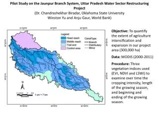
Pilot Study on the Jaunpur Branch System, Uttar Pradesh Water Sector Restructuring Project (Dr. Chandrashekhar Biradar , Oklahoma State University Winston Yu and Anju Gaur, World Bank).

E N D
Pilot Study on the Jaunpur Branch System, Uttar Pradesh Water Sector Restructuring Project (Dr. ChandrashekharBiradar, Oklahoma State University Winston Yu and Anju Gaur, World Bank) Objective: To quantify the extent of agriculture intensification and expansion in our project area (300,000 ha) Data: MODIS (2000-2011) Procedure: Three vegetation indices used (EVI, NDVI and LSWI) to examine over time the cropping intensity, length of the growing season, and beginning and ending of the growing season.
Cropping Intensity in Jaunpur Branch before and after project interventions
The Field-Photo Library at the University of Oklahoma (http://www.eomf.ou.edu/photos) Users can upload geo-tagged field photos, and classify photos by predefined land cover types (IGBP), and write additional information for photos. User can also download photos and thematic databases (e.g., land cover types).
Link geo-tagged photos with MODIS time series data for land use dynamics
Question: Are current global sea level rise estimates relevant to the coastal areas of Bangladesh ? Data: Landsat (2000-2009) Most impact assessments assume static coastlines Baseline 62 cm