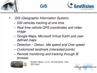
GIS
40 likes | 158 Views
The main issue identified in the Water Information System in Europe (WISE) meeting in Ispra in 2005 is the misalignment of administrative borders in Lithuania, Latvia, and Poland due to differing topographic information. This discrepancy is hindering accurate data collection for environmental protection efforts. This study proposes solutions to align topographic data for better integration into the WISE system.

GIS
E N D
Presentation Transcript
The main problem, identified in Water information system in Europe (WISE) meeting in Ispra, in 17-18 October, 2005, is misalignment of administrative borders of Lithuania, Latvia and Poland, what is determined by different type of topographic information (different scale, different topology of objects), provided by countries to WISE system.
According to new national requirements, EPA gathers and stores spatial data to scale 1:10 000 but also EPA has spatial data and to scales 1: 50 000. • River basins in Lithuania were delineated by using topographic maps, made in 1967-1972, to scale 1:25 000.
EPA suggests to gather, store and provide topographic information to WISE to scale 1: 50 000, by using: • for Lithuania-Latvia border – scale 10 000 data based administrative borders; • In order to harmonize the administrative borders of Lithuania and Latvia we suggest to exchange the topographic information on the administrative borders in format ARCINFO coverage and WGS 84 coordinates system.
Environmental Protection Agency (EPA) is responsible for the delivering necessary topographic data to WISE system in Lithuania. It was submitted administrative borders data to WISE system to scale 1:50 000.