
Uploaded by
gil
3 SLIDES
137 VIEWS
30LIKES
Enhancing Emergency Response with Local GIS Data for Faster Decision-Making
DESCRIPTION
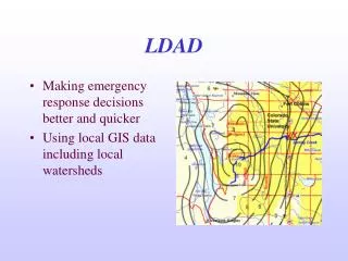
This study focuses on improving emergency response decisions by utilizing local Geographic Information System (GIS) data, including watershed information and radar imagery from July 28, 1997. By integrating this data into crisis management strategies, responders can make informed decisions quickly, ensuring effective action during emergencies. The use of local resources and historical data aids in assessing risks and implementing timely responses, ultimately enhancing community safety and resilience in the face of disasters.
Download
1 / 3
Download Presentation 
Enhancing Emergency Response with Local GIS Data for Faster Decision-Making
An Image/Link below is provided (as is) to download presentation
Download Policy: Content on the Website is provided to you AS IS for your information and personal use and may not be sold / licensed / shared on other websites without getting consent from its author.
Content is provided to you AS IS for your information and personal use only.
Download presentation by click this link.
While downloading, if for some reason you are not able to download a presentation, the publisher may have deleted the file from their server.
During download, if you can't get a presentation, the file might be deleted by the publisher.
E N D
Presentation Transcript
LDAD • Making emergency response decisions better and quicker • Using local GIS data including local watersheds
More Related