Download
1 / 1
10 likes | 120 Views
Scalar Transport and Dispersion in Complex Terrain within a High-Resolution Mass-Consistent Wind Modeling Framework Natalie Wagenbrenner, Steve Edburg , Brian Lamb, Laboratory for Atmospheric Research, Washington State University, Pullman, WA 99164

E N D
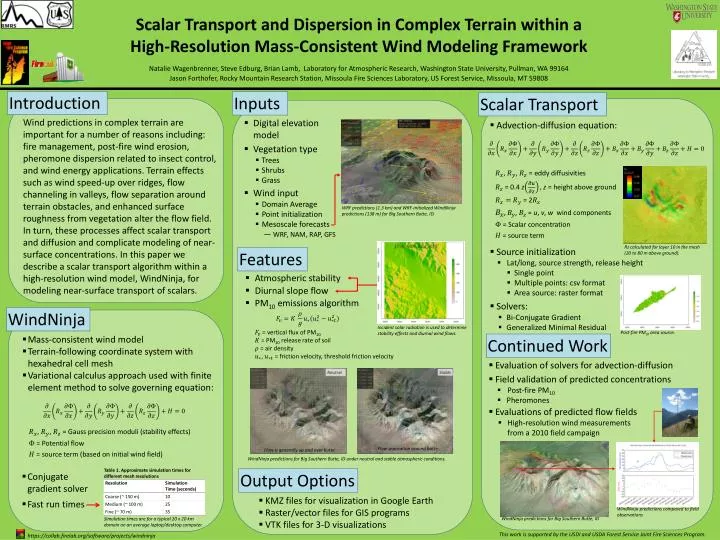
Scalar Transport and Dispersion in Complex Terrain within a High-Resolution Mass-Consistent Wind Modeling Framework Natalie Wagenbrenner, Steve Edburg, Brian Lamb, Laboratory for Atmospheric Research, Washington State University, Pullman, WA 99164 Jason Forthofer, Rocky Mountain Research Station, Missoula Fire Sciences Laboratory, US Forest Service, Missoula, MT 59808 (1) Introduction Inputs Scalar Transport Wind predictions in complex terrain are important for a number of reasons including: fire management, post-fire wind erosion, pheromone dispersion related to insect control, and wind energy applications. Terrain effects such as wind speed-up over ridges, flow channeling in valleys, flow separation around terrain obstacles, and enhanced surface roughness from vegetation alter the flow field. In turn, these processes affect scalar transport and diffusion and complicate modeling of near-surface concentrations. In this paper we describe a scalar transport algorithm within a high-resolution wind model, WindNinja, for modeling near-surface transport of scalars. • Digital elevation model • Vegetation type • Trees • Shrubs • Grass • Advection-diffusion equation: , , = eddy diffusivities = 0.4 zz = height above ground = 2 , = u, v, w wind components = Scalar concentration = source term • Wind input • Domain Average • Point initialization • Mesoscale forecasts • ― WRF, NAM, RAP, GFS WRF predictions (1.3 km) and WRF-initialized WindNinja predictions (138 m) for Big Southern Butte, ID. Rz calculated for layer 10 in the mesh (20 to 80 m above ground). • Source initialization • Lat/long, source strength, release height • Single point • Multiple points: csv format • Area source: raster format • Solvers: • Bi-Conjugate Gradient • Generalized Minimal Residual Features • Atmospheric stability • Diurnal slope flow • PM10 emissions algorithm WindNinja Incident solar radiation is used to determine stability effects and diurnal wind flows. = vertical flux of PM10 = PM10 release rate of soil = air density , = friction velocity, threshold friction velocity Post-fire PM10 area source. • Mass-consistent wind model • Terrain-following coordinate system with hexahedral cell mesh • Variational calculus approach used with finite element method to solve governing equation: Continued Work • Evaluation of solvers for advection-diffusion • Field validation of predicted concentrations • Post-fire PM10 • Pheromones • Evaluations of predicted flow fields • High-resolution wind measurements from a 2010 field campaign , , = Gauss precision moduli (stability effects) = Potential flow = source term (based on initial wind field) Flow separation around butte. Flow is generally up and over butte. WindNinja predictions for Big Southern Butte, ID under neutral and stable atmospheric conditions. Table 1. Approximate simulation times for different mesh resolutions Output Options • Conjugate gradient solver • Fast run times • KMZ files for visualization in Google Earth • Raster/vector files for GIS programs • VTK files for 3-D visualizations WindNinja predictions compared to field observations WindNinja predictions for Big Southern Butte, ID Simulation times are for a typical 20 x 20 km domain on an average laptop/desktop computer. This work is supported by the USDI and USDA Forest Service Joint Fire Sciences Program. https://collab.firelab.org/software/projects/windninja