Download
1 / 41
410 likes | 660 Views
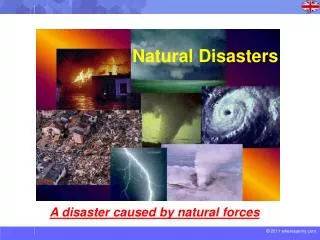
Addressing Land Issues after Natural Disasters. Lessons from Aceh Daniel Fitzpatrick. Aceh Tsunami Impact Zone. Urban Destruction. Banda Aceh 6 - Before. Banda Aceh 6 - After. Banda Aceh 7 - Before. Banda Aceh 7 - After. Banda Aceh 1 - Before. Banda Aceh 1 - After. Coastal Aceh - Before.

E N D
Addressing Land Issues after Natural Disasters Lessons from Aceh Daniel Fitzpatrick
Damage to Land Administration System (A) • 126,602 people killed and 93,638 people missing • 514,150 people displaced • 252,223 houses totally destroyed or partially damaged as a result of the December 26 tsunami • Approximately 23,330 ha of rice fields and 126,806 ha of other agricultural or garden areas damaged by mud, salination, sand or erosion • Approximately 300,000 land parcels (170,000 urban; 130,000 rural) out of an estimated 1,498,200 in NAD generally affected by tsunami-related damage
Damage to Land Administration System (B) • Destruction of the National Land Agency (BPN) office in Kota Banda Aceh; 2 other BPN offices also destroyed and 3 severely damaged • Loss of approximately 30% of the staff in the Banda Aceh BPN office • Substantial damage to or loss of land records in BPN and sub-district offices (approximately 80%), including almost all cadastral maps. • Land books: 10% lost; 90% badly damaged. • Widespread loss of personal identity records in tsunami-affected areas • Significant inundation and subsidence. • Significant obscuring or obliteration of boundary markers.
Four Main Land Issues • Securing land rights and tenure • Mitigation and land use planning • Protecting the Vulnerable • Secondary rights-holders • The landless • Women and children • Land acquisition
The Institutional Context • Fragmented government system • Secessionist conflict • Tsunami-affected government capacity • Reconstruction authority • Poor quality land administration • Lots of NGOs
Securing land rights and tenure • Reconstruction of Land Administration System in Aceh and Nias (RALAS) Project • World Bank-designed • Multi-donor trust fund • National Land Agency (BPN) implementation
Attachment 4-2 • THE LETTER OF STATEMENT OF THE INSTALMENT OF BOUNDARY STAKES AND THE PHYSICAL OWNERSHIP OF A PIECE OF LAND • Regency/Municipality: District : Village : Neighbourhood (RT/RW) : Street/Block/Jurong: Code/No . . . . .(the same as the code in the map) • DATA OF TRUSTEE/GUARDIAN (filled in by those acting as trustee/guardian/representative)Name : . . . . . . . . . . . . . . . . . . . . . . . . . . . . . . . .Place/Date of Birth (age) : . . . . . . . . . . . . . . . . . . . . . . . . . . . . . . . Address : . . . . . . . . . . . . . . . . . . ... . . . . . . .. . . . .Occupation : . . . . . . . . . . . . . . . . . . . . . .. . . . . .. . . . .Acting on behalf of : Trustee/guardian of . . . . . . . . . . . . .. . . . . . . . . . (as filled in as follows) • DATA OF LAND OWNER[S]: (According to the ID, if any)Name : . . . . . . . . . . . . . . . . . . . . . . .. . . . . (M/F)Place/Date of Birth (age) : . . . . . . . . . . . . . . . . . . .. . . . . . . . . . .Identity No : . . . . . . . . . . . . . . . . . . . . . . . . . . . . . Status : Married/unmarried/widow/widowerName of husband/wife : . . . . . . . . . . . . . . . . . . . . .Present/temporary address : . . . . . . . . . . . .. . . . . . . . . . . . .. . . . . . . . . . . . . . . . . . . .. . . . . . . . . . . . . . . .Address before Tsunami : . . . . . . . . . . . . . . . . . . . .. . . . . . . . . . . . . . . . . . . . . . . . . . . . . . . . . . . .. . . . . Past occupation : . . . . . . . . . . . . . . . . . . . . . . . . . . . . . .Present occupation : . . . . . . . . . . . . . . . . . . . . . . . . .. . . . . .Status of land : HM/HGB/HGU/HPCertificate : with/without certificateHak tanggungan : as collateral/not collateralThis land is owned since : . . . . . . . . . . .. . . . . . . . . (d/m/y)Obtained from : purchase/hibah/inheritance/right extension . . . . . . . . . . . . . . . . . . . . . . . . . . . . . . . . . . . .This land will be certified in the names of 1. . . . . . . . . . . . . . . . . . . . . . . . . . . . 2. . . . . . . . . . . . . . . . . . . . . . . . . . . . 3. . . . . . . . . . . . . . . . . . . . . . . . . . . .IF THERE IS NO ID CARD, THIS PART MUST BE FILLED IN Thumb mark of land owner • Thumb marking is done in presence of geucik • Acknowledged the accuracy of the data by geucik/head of village.(…….Name of Geucik/the head of village…..)This land is owned by the undersigned and its boundaries have been installed witnessed by all neighbors still alive. • a • b • Sketch of the piece of land • (made by the land owner) • Jalan melati • Xcdfe • Example • The undersigned are responsible in the court of law on the accuracy of their claims in this document. . . . . . . . . . . ., …. …. ……. Legal land owner/heir/guardian Full Name( signature)Family witness:1husband/wife…………………….2)…………………………………….Neighbouring land owner witnesses a. . . . . . . . . . . . signatureb. . . . . . . . . . . . c. . . . . . . . . . . .d. . . . . . . . . . . .e. . . . . . . . . . . .f. . . . . . . . . . . . .Village institution witnesses:Imam Menasah . . . . signatureTuhapeut . . . . . . . . . . Geucik . . . . . . . .
Table 7: Inheritance Case Brought Before Mahkamah Syar’iyah (Banda Aceh and Jantho)
By September 30, 2007, 210,591 land parcels had been surveyed, and 104,551 land title certificates distributed by BPN.
Securing land rights and tenure: Lessons • Community-driven determinations of land ownership can help to avoid delays and conflict in the process of restoring housing after disasters. • Community-based identification of heirs can identify landowners for reconstruction purposes in a rapid and relatively conflict-free manner, particularly in circumstances of high mortality. • The identification of land boundaries through community-driven adjudication can often be inaccurate, and at times opportunistic in nature. Community-driven adjudication need to be supplemented by trained surveyors with legal authority to demarcate boundaries. • Community-driven land ownership determinations may be subject to undue delays where they need to be cross-checked against pre-disaster land records. • Community-driven determinations must be fully supported in law to avoid institutional delays and the emergence of long-term disputes. • Systematic land titling may be useful for longer term investment and recovery, but it is not of itself an appropriate tool to establish tenure security for the purposes of house reconstruction after a disaster.
Mitigation and land use planning: lessons • Groups with location-dependent livelihoods, and limited opportunities for off-land employment, will face disproportionate income risks if they are relocated from their pre-disaster lands. • Reconstruction should be allowed to proceed in areas vulnerable to future disasters if mitigation measures short of resettlement will suffice to reduce disaster vulnerability to an acceptable level. • Minimising reconstruction in unsafe areas should not be based on outright prohibitions, which will cause controversy and popular protests, but on community consensus and the use of safety standards and financial or infrastructure incentives.
Protecting the Vulnerable: Renters and Squatters • February 2007: 14,280 verified victim households remaining in the barracks, of which as many as 4,082 households were renters.
Renters and Squatters: Lessons • Temporary living centres cannot be decommissioned unless housing, or access to housing, is provided to renters and squatters. Unless they are decommissioned, temporary living centres can become long-term settlements characterised by poor living conditions, unregulated development and inadequate access to infrastructure and services. • There may be a degree of government caution in dealing with the housing needs of renters and squatters because providing them with land can create equivalent demands outside the disaster zone. Because international actors generally need to work with or through government agencies, the appropriate international response to government inaction may be assistance for advocacy or policy development measures relating to renters and squatters. • The scope and scale of any renter and squatter problem needs to be assessed soon after a disaster. Undue delays may lead to social conflict as landless groups agitate for housing, or engage in land invasions and construction of extralegal settlements.
Protecting to vulnerable: women • Approximately 14,000 displaced widows • Syariah law of inheritance • Local misunderstanding of complex Syariah cases. • Localised denial of widows’ claims by male relatives and neighbours.
Women and land titling • Low rates of co-titling marital land • Need for gendered disaggregated data (new program underway)
Gender and land: Lessons • Early collection of gender-disaggregated data. • Awareness of localised dispossession risks: assessment and response. • Importance of land rights adjudication procedures.
Land acquisition for resettlement • February 2007: BRR estimates that 13,068 households require resettlement. • Some community-based resettlement programs involving purchase of land, or grant by local governments.
[1] The figures for Banda Aceh are unreliable as the initial calculation of persons requiring resettlement is lower than the numbers ready resettled.
Land acquisition: lessons • Rapid needs assessment • Rapid identification and verification of beneficiaries • Little lead time for consultation and participation • Land acquisition takes time: start early stop