Download
1 / 16
160 likes | 287 Views
OneGeology Making geological map data for the Earth accessible. 1 March 2008. OneGeology Secretariat. First …… Thank you to you all !. OneGeology is …….

E N D
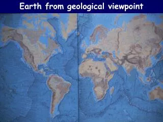
OneGeology Making geological map data for the Earth accessible 1 March 2008 OneGeology Secretariat
OneGeology is ……. A project to make web-accessible the best available geological map data worldwide at a scale of about 1:1 million, as a Geological Survey contribution to the International Year of Planet Earth 2008 This is the official mission statement !
Who is involved? International Bodies An International Consortium of Geological Surveys International Year of Planet Earth (IYPE) www.yearofplanetearth.org International Steering Committee for Global Mapping (ISCGM) www.iscgm.org Commission for the Geological Map of the World (CGMW) http://ccgm.free.fr/ International Union of Geological Sciences (IUGS) www.iugs.org/ UNESCO http://portal.unesco.org/en/ Co-ordinating Committee for Geoscience Programmes in East and Southeast Asia (CCOP) www.ccop.org.th/ Commission for the Management and Application of Geoscience Information (CGI) www.cgi-iugs.org International Lithosphere Program http://sclilp.gfz-potsdam.de/ EuroGeoSurveys http://www.eurogeosurveys.org/
Who is involved? Surveys and organisations who are participating
No What is the format of your maps/data? Do you want to participate? Yes Yes Convert to interchange format No Paper Raster Vector Serve to OneGeology portal and provide access Scan The basic OneGeology proposition Have geological maps/data ca 1:500000 - &1:5 million?
“The Brighton Accord” • 81 participants from 43 nations and 53 national and international bodies • Agreed OneGeology should proceed • Mission: improve the accessibility of global, regional and national geological map data & increase usefulness to society • Focus on making accessible existing geological map coverage • Recognise that this will catalyse scientific harmonisation of map data globally. • Geological Surveys to work together to develop interchange standard to make their data interoperable • Progress to be presented at the International Geological Congress in Oslo in 2008 This is the official mandate and core vision !
Progress since Brighton in March 2007 • Technical Work on track - prototype OneGeology portal and cookbooks now available • €3.3 million, 21 nation proposal to EC for OneGeology-Europe & related proposal sent to USA NSF • Governance issues progressed - IPR, funding, future corporate structure etc • Preparation work for the big launch at the IGC33 in Oslo - at the Opening Ceremony ! • Many presentations on OneGeology worldwide - resulting in new recruits and support • OneGeology has momentum and has captured the imagination of people inside and outside the geosciences – IYPE launch Paris Latest news - 95% certain to be funded !
OneGeology-Europe – major objectives • make existing digital geological spatial data more easily accessible (i.e. contribute to OneGeology) • make a significant contribution to the progress of INSPIRE – i.e. develop systems and protocols to better enable the discovery, viewing, downloading and sharing of core European spatial geological data. • demonstrate best practice examples of the delivery and application of geological spatial data in the public and private sectors.
OneGeology-Europe coverage OneGeology-Europe data provider and consortium member OneGeology data provider
10 Results and Deliverables • interoperable geology spatial dataset at 1:1 million scale for all onshore EU • scientific and informatics specification for the harmonisation of geological data at this resolution; progress towards a harmonised dataset • view service providing access to best practice high resolution geological spatial data services for 6 Member States • 2-4 pilot and case studies on cross-border delivery of harmonised high resolution data access • multilingual discovery metadata for all participants’ geological and applied map data • robust data model, schema and mark-up language for the geosciences • web portal providing easy multilingual access to the above data and examples of user-focused web services • best practice examples of the delivery of geological data to a range of users • guidance and code of practice on licencing and clearing arrangements facilitating re-use of geological spatial data • exchange of science, technology, informatics and communication skills and experience across the EU and globally.
33 IGC in Oslo • IGC Opening Plenary Launch of OneGeology • Press conference • Technical launch of the OneGeology portal • Booth at the exhibition • OneGeology-Transparent Earth symposium • Steering Group meeting • Management group meeting • Pre-launch organising meeting • Technical group meeting • ICOGS (Directors) meeting
Summary OneGeology will …… • help to make existing data accessible to the world (adding value to existing resources) • transfer know-how • spread standards and interoperability (GeoSciML) OneGeology is about …… pragmatism