The Iditarod: A Journey Through Alaska’s Iconic Dog Sled Race
The Iditarod race stretches 1,122 miles from Anchorage to Nome, Alaska, celebrating the spirit of adventure and the bond between mushers and their dogs. Anchorage kicks off the race, attracting thousands of spectators, while key checkpoints like Eagle River, Wasilla, and Rainy Pass offer vital support to the teams. Each checkpoint presents unique experiences, including hearty meals and the chance for mushers to rest. This historic event showcases Alaska's breathtaking landscapes and rugged conditions, making it a must-see for adventure seekers.

The Iditarod: A Journey Through Alaska’s Iconic Dog Sled Race
E N D
Presentation Transcript
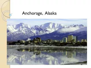
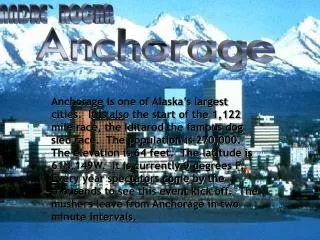
ANDRE` ROCHA Anchorage Anchorage is one of Alaska’s largest cities. It is also the start of the 1,122 mile race, the Iditarod the famous dog sled race. The population is 270,000. The elevation is 64 feet. The latitude is 61N,149W. It is currently 9 degrees F. Every year spectators come by the thousands to see this event kick off. The mushers leave from Anchorage in two minute intervals.
Eagle River By Pierce Peasley Eagle River is the second checkpoint. The mushers ride on trucks from Eagle River to Willow. The elevation is 397 ft. The population of it is 30,550 people.. You can get moose stew, cornbread and refreshments for all the mushers and officials at the checkpoint. The distance to Nome is 1111 miles or 1787 kilometers. The latitude and longitude are 61.317N and 149.567W. The temperature is 121 degrees Fahrenheit. The wind chill is -1 degrees. The wind speed is 7mph and the visibility is 7 miles.
Wasilla/Willow By Tray Hiatt Willow (Wasilla) Is the third stop in the iditarod. It has a population of 1,658. Its distance to Nome is 1,052 Miles. Its elevation is 348 ft. It’s latitude is 61.77 N. and its longitude is 149.99 W. Its Weather conditions have been very bad this March. They made it the restart for the race because of the bad weather but it was bad there to. That’s my report on Wasilla/Willow.
Yentna Yentna is the fourth checkpoint in the Iditarod race. It is a very small town and has the population of only 8. From Yentna to Nome it is 1007 miles. At this checkpoint the mushers who decide to stay will get a cold glass of water and a big warm plate of spaghetti. This is a very good stop for the mushers. The elevation for Yentna is 77ft. The weather for march is 19 degrees F. Wind chill is 7 degrees F. By Kylie Olson
Rebecka Deglman 4hr Skwentna Skwentna has a population of 90. It has an elevation of 189ft/58m. The latitude is 61.960 N and the longitude is 151.167 W.The distance to Nome is: 973 miles / 1,566 km. It is the busiest checkpoint since all the mushers hit it on the first night of the race. 30 or 40 teams will check in on the river at once. Food bags and 1 bale of hay are available for the teams.Water is also available through a hole in the ice. After getting to the check point veterinarians will look over the dogs and after that there is the option of going to the lodge for a good meal and drying clothes and don’t for get the good nights sleep.The current weather is –9Fand –23C.This is leg number 4 of the race. The current temperature is –20 F.
Finger lake Sammy McClain Finger lake is very popular for airplane landing. The landing is right next to the dog parking. It is good that it has a lot of tourists. Population is 2 people. Distance to Nome is 928mi. Elevation is 979ft. Weather is Clear 19 Degrees -7c
Rainy Pass By: Molly Grider Rainy Pass has the highest elevation throughout the whole race. It’s elevation is 3,771 ft.or 1149 m. Rainy Pass’s latitude is 62.222 N and it’s longitude is 153.097 W. It’s checkpoint is on Puntilla Lake in the heart of Alaska. Rainy Pass is the 7th stop. Rainy Pass’s lodge is open throughout the winter. It has food, fuel, and lodging. Water is available is through a hole in the ice. The weather in Rainy Pass is clear. It is 19 degrees F. and –7 degrees C.
BY Katie Seymour ROHN Is the 8th check point in the Iditarod Race. The distance to ROHN is 850 mi. The elevation to on ROHN is 1440 ft the latitude on ROHN is 62.295 North and west the longitude is 153.373. And the check point before ROHN is Rainy pass.ROHN is on the steep hill and it is almost down the hill. And the point after ROHN is NIKOLAL. ROHN
It is the 9th stop along the Iditarod trail. • The distance from Nikolai to Nome is 770 miles. • The population is 125. The elevation is 413 ft. • The latitude is 63.018 N and the longitude is 150.380 W. • Fun Facts • Veterans say that if you have made it to Nikolai with the team spirit high, there is a good chance of finishing the race. • It has cold winters and short warm summers. • The Kuskokwim River is generally frozen over from November through May. • Winter temperatures range from -62 to 0 and the summer temperatures range from 42 to 80 degrees . Nikolai By Taylor Nelson
McGrath • Population: 479 • Distance To Nome: 722 miles. • Elevation: 328ft. • Latitude: 62.953 N • Longitude: 155.603 W • McGrath is stop #9 By Anita Finnerty
Tokotna Takotna is the 11 checkpoint in the Iditarod race. The distance to Nome is 704 miles. This small checkpoint has its advantages for a 24 hour layovers. The checkpoint has made every musher a steak dinner when they stop. If a sled swap is intended during the 24 hour layover they will make a shipment to the checkpoint for your sled.The elevation is 575 ft./ 175 m the latitude is 62.993 north and the longitude is 156.067 west. The population is 51 people. Today the weather conditions in Tokotna is –26 degrees Fahrenheit and – 32 degrees Celsius. The visibility is 10 miles. Brittany Jenkins
OPH IR CHECKPOINT IDITAROD ROUTE) (SOUTHERN • Leg 11 in the Iditarod. • Population 0 • Elevation 696 ft. • Distance to Nome, 679 mi. • Latitude, 63.135 N • Longitude, 156.503 W SLATER ASHENHURST
Iditarod By Kort Riddle In 1912 Iditarod had 10,000 people in population. Now it has 0 in population. In 1930 the river cut a new path so Iditarod turned into a ghost town. The checkpoint is in a little old cabin where sometimes mushers can sleep. Iditarod is 589 miles from Nome so who ever gets there is half way through. Iditarod was a gold mine. Iditarod is the 13th checkpoint in the Iditarod Race. The Latitude and longetude is 62 N. and 158 W. The weather there is –26 degrees F. You can see 10 miles in front of you.
Shageluk Strategically and symbolically, the run from Iditarod to Shageluk is important because it demonstrates which teams have the strength and staying power to win the Iditarod. Experienced race fans begin to watch for a team to emerge as the dominant competitor. Mushers in the lead pack begin thinking seriously about making a move to shake the weaker teams from the front.
ANVIK By CEASAR ZAVALA DISTANCE TO NOME: 499 MI. ELEVATION: 154 FT. LATITUDE: 62.647 N LONGITUDE: 160.188 W LEG NUMBER: 13
Graying Stop #: 15 Distance: 481mil to Nome Population: 194 Elevation: 59ft Interesting facts: If musters are lucky they can see the sun set over the Weather: fare sky's hi is –15 degrees
Eagle Island by Jhett Eike -24 Degree’s F. and there is no wind chill. In Eagle Island they have 421 miles in tell get to Nome. I am the 17 checkpoint in the iditarod trail. So far I have nobody at me right now. I have a elevation of 69 feet. My latitude is63.658 North an longitude is 159.393 West. A 1997 iditarod musher said that it was so remote, it is actually beyond the edge of the planet. The checkpoint is a summer fishing cabin owned by multiple iditarod runner, Kenny Chase. it is a good place to take a little nape and boil some water over a glowing oil stove. The sound of the wolves howling is the only thing that is piercing through the deep silence of the remote area.
KALTAG DALTON FOOS The population of Kaltag is 234. The distance from Kaltag to Nome is 351 miles (565km). The elevation is 125 ft.The latitude is 64.326 N and the longitude is 158.742 W.
Unalakleet By Taylor Bush • The stretch of trail is the gateway to the Bering Sea. • On this part of the trail mushers can expect sudden storms and ample weather. • There is a 2,500 $ prize for the first musher to get to Unalakeet.
Shaktoolik population is 199 people. It is 219 miles from Nome. The elevation is 3 feet. Latitude is 64.363 North the longitude is 161.200 West. It is -18degrees c. there. It is check point 20. ShaktooliK
Koyuk Distance to Nome: 171 mi. Population: 258 Elevation: 38 ft. 64.935 N Latitude/161.155 W longitude Interesting facts: In the first Iditarod the race did not go through Koyuk. The trail skirted the water a lot closer then the race today. Koyuk is towards the end of the race in Nome. Stop number: 21 The currant temperature: H –8F L-18F
Krista Betts Elim The population in Elim is 287 people. The longitude is 162.267 W and the latitude is 64.615 N. I think that Elim has more population than other of the places. The elevation of Elim is 14 ft./4.2 m. Elim is one of those places that are right in front of the hill so if you lived there you would problebly be living near the hill and it is huge. All riders must be aware for the road bumps!
Golovin -4F WC –16F Golovin I the land between Golovin Bay and Golovin lagoon. It was originally an Inupiat village called Chinik. Golovin was named after captian Vasily Golovin. Golovin was also a gold field.
White Moutain The distance from White Mountain to Nome is 77 miles . In White Mountain Alaska the population is 209 . The elevation for White Mountain is 132 ft . The elevation is 132 ft /40m and the latitude 64.682 N and the longitude is 163.407 W . They need to have a 8 hour lay over in White Mountain the go
Taylor McCullough Safety Safety is the checkpoint just before Nome Which is 22 miles from Nome. Here is a good spot to lie down and rest. That’s because there is no shelter from here to Nome. The population is none but there is a station where the musters can go to if there is a storm rolling in where there will be a nice cup of soup and cocoa. The stop number is 17. The elevation is 64.467N 164.758W. Right now the weather is unknown. In 1898 it was called Anvil city.
Nome The stop number in the Iditarod race for this checkpoint is #18 and is the last stop of the race. The population of this wonderful Alaskan city is 3,502 people. The elevation of Nome is 45feet/ 14miles. The latitude of Nome is 64.513N and longitude is 165.442W. Nome is near the ocean and is on a peninsula looking thing on the west side of the state. The weather right now at Nome is –6 . There is a wind chill advisory tonight and for tomorrow. The high for today is expected to be –3 and the low for tonight is –13 . The average high for this city is 18 and the low is 1 . The record high and low in Nome is March(which is the Iditarod month) is 43 and the low is –46 . Numerous stores, restaurants and bars line Nome’s infamous Front Street. People wait here to see the mushers finish the last great race.