Higher Atmosphere
Higher Atmosphere. Higher Atmosphere. Higher Atmosphere. An isohyet is a line on a map connecting points having the same amount of rainfall in a given period. Higher Atmosphere. 20 ºN. 3. 250. 15 ºN. 15. 500. 25. 250. 1000. 36. 60. 500. 2000. 10 ºN. 110. 3000. 75. 1000.

Higher Atmosphere
E N D
Presentation Transcript
Higher Atmosphere
Higher Atmosphere
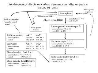
Higher Atmosphere An isohyet is a line on a map connecting points having the same amount of rainfall in a given period.
Higher Atmosphere 20ºN 3 250 15ºN 15 500 25 250 1000 36 60 500 2000 10ºN 110 3000 75 1000 3000 123 111 1000 5º 2000 2000 3000 3000 2000 KEY 3000 EQUATOR 0º Isohyet, with rainfall in mm Average number of days with rain 250 75
Higher Atmosphere 1. Describe the differences between the graphs [8 marks]
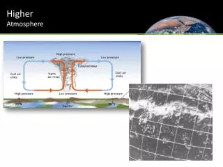
Higher Atmosphere Higher Atmosphere • Describe and explain the Differences in rainfall in West Africa [8 marks]: • These differences can be attributed to the ITCZ and the movement of the Maritime Tropical and Continental Tropical air masses over the course of the year. [1] • For example, Abidjan, on the Gulf of Guinea coast, is influenced by hot, humid mT air for most of the year [1], accounting for its higher total annual precipitation and greater number of rain days [1]. The twin precipitation peaks can be attributed to the ITCZ moving northwards in the early part of the year and then southwards later in the year in line with the overhead sun [2]. • Gao, on the other hand, is under the influence of hot, dry cT air for most of the year and therefore has far fewer rain days and a very low total annual precipitation figure as it lies well to the north of the ITCZ for most of the year [2]. • Bobo-Dioulasso again is in an “in-between‟ position, getting more rain days and heavy summer precipitation from June-August when the ITCZ is furthest north [1]. • Read Pages 20 to 26 Q2,3 and 4 on page 29 and 30 Tropical Climate Questions
Higher Atmosphere Higher Atmosphere Total Precipitation In Gao there is 200mm of rainfall throughout the year, typical of a hot desert climate. However, in the South (Abidjan) it is much wetter as there is 1700mm of total rainfall. Bobo-Dioulasso on the other hand is ‘in-between’ with 1000mm of rain a year. Days with Precipitation In terms of rain days, there appears to be more rain days around June and July. In Gao there is much less, (a maximum of 5 in August) whereas in Abidjan there are many more (August has 11 and June has 18). Pattern of Rainfall There is a distinct wet and dry season in Bobo- Dioulasso. It is much drier around December and wetter in June/July. There is a distinct twin peak in Abidjan occuring in June and October (Quote).