Download
1 / 9
90 likes | 247 Views
Suggested Method for Datum Determination for the Radar Gauges provided for ODINAFRICA and GLOSS-Africa. P.L.Woodworth. The Problem Is:.

E N D
Suggested Method for Datum Determination for the Radar Gauges provided for ODINAFRICA and GLOSS-Africa P.L.Woodworth
The Problem Is: • The Kalestos should provide good time series of sea level. But the time series may contain an unknown offset (datum uncertainty) which needs to be determined by simultaneous measurements of sea level by another technique. That technique can involve the use of a tide pole, or, more desirably, the use of dipping measurements in a nearby permanent or temporary stilling well with the use of an electronic ‘dipper’.
Pole or Dipping Measurements • The routine pole or dipping measurements should be made by a local observer. • They should be made at least weekly in relatively calm conditions for an hour or so within a couple of hours of either high or low water, when sea level is not changing very fast.
Why Take Measurements Around High/Low Water? • Tide pole or dipping measurements are instantaneous estimates of sea level, whereas the radar values will be averages over a certain period (possibly as much as 15 minutes). • So it is important that sea level does not change significantly during that averaging period. For example, at a station with a large tide, the sea level could change by several cm in a minute at mid-tide. • There could be small differences in the clocks used by the observer and by the radar gauge, which will convert into a significant height-difference when the tide is changing rapidly.
How Often? • The local observer should try to make his measurements over a period of at least an hour once a week, with eventually an equal number of high and low water measurements obtained. With some practice, he should be able to make a tide pole or dipping measurement every few minutes, with values noted in a book along with the precise time. Therefore, approximately 10-20 independent calibrations could be obtained in his weekly visit to the gauge.
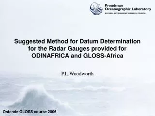
CP Stilling well Tide pole Radar gauge d P R
How will the Different Sea Level Measurements be Used? • The above figure shows the different sea level measurements at the tide gauge station. In addition to the radar gauge, the station must also have a tide pole and a permanent or temporary stilling well. • The tide pole should be adjusted to show sea level values relative to a defined datum (usually Chart Datum, sometimes called the Hydrographic Zero, for the station) with the height difference between that datum and the height of the main Tide Gauge Benchmark determined from local levelling repeated at least annually (see the GLOSS tide gauge manuals). • Similarly, there should be a Contact Point on the stilling well relative to which dipping measurements can be made. The usual contact point is the top of the well. Levelling will determine the difference in height between the CP and CD and TGBM.
Some Mathematics • For present purposes, let us use CD (HZ) as our reference level, then: • P = sea level relative to CD as measured by the tide pole • W = sea level measured by the stilling well = Hcp – d where • Hcp = height of the Contact Point of the well above CD and • d = dipping measurement of the water level in the well • R = value of sea level from the radar gauge which needs to be adjusted to be relative to CD. • (At sites which read the radar gauge through the OTT logosens logger then R will be measured upwards as normal. For the gauges read through the Orbcomm boxes R will be the range from the transducer downwards to the sea level. Here we assume the former.) • From sets of simultaneous data (see above) we can then calculate an offset O from: • O = P – R or W-R such that • R corrected = R measured + O • And then the corrected values of R will be radar measurements of sea level relative to CD.
What to do with the Tide Pole or Dipping Measurements? • We suggest that each week an excel sheet is completed listing the tide pole or dipping values containing for example: • Station (e.g. Pemba) • Measurement type (e.g. pole or dip) • Time (in UT/GMT) (e.g. 15 36) correct to the nearest minute (accurate watch/radio required) • Measurement (e.g. 331.5) in cm [if ‘pole’ then the value shown by the pole should be entered here, we will know from separate correspondence how the tide pole datum relates to TGBM] [if ‘dip’, then the downward value obtained from the dipper should be entered here, we will know from separate correspondence what the Hcp value is.] • The excel sheets should be sent regularly to a central email (e.g. PSMSL, to be decided) which will be set up to collect the information and subsequently make it available to all concerned. • As ODINAFRICA develops, we will have to see how these suggested arrangements should be modified.