Download
1 / 2
20 likes | 156 Views
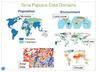
This dataset encompasses a detailed integration of population microdata with land cover and environmental characteristics, focusing on individuals and households. It is designed for location-based analysis and features areal data, climate indicators, and land use information. Summarized characteristics for administrative districts provide insights into the relationship between populations and their social and environmental contexts. The data is valuable for researchers, policymakers, and environmental planners aiming to understand demographic trends and their interactions with the environment.

E N D
Terra Populus Data Domains Population Microdata Land cover Environment Individuals and households Land use Areal Data Climate
Location-Based Integration Individuals and households with their environmental and social context Summarized population and environmental characteristics for administrative districts Rasters of population and environment data