Download
1 / 15
150 likes | 294 Views
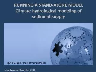
RUNNING A STAND-ALONE MODEL Climate-hydrological modeling of sediment supply . Run & Couple Surface Dynamics Models. Run & Couple Surface Dynamics Models. Irina Overeem, December 2010. Outline. OBJECTIVE Learn How to Run a Model in the CMT EDUCATIONAL EXAMPLE HYDROTREND

E N D
RUNNING A STAND-ALONE MODELClimate-hydrological modeling of sediment supply Run & Couple Surface Dynamics Models Run & Couple Surface Dynamics Models Irina Overeem, December 2010
Outline OBJECTIVE • Learn How to Run a Model in the CMT EDUCATIONAL EXAMPLE HYDROTREND • Why is sediment supply important? Delta formation • Quantifying Sediment Supply Processes • Simple Scenario and User Changes to Input Parameters HANDS-ON • Run a climate change scenario and human impacts scenario for 21st century
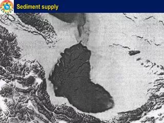
Ganges-Brahmaputra Delta, India & BD Mississippi Delta, USA Why Model Sediment Supply? Worldwide 500 million people live in low-lying deltas Thirty-three major deltas combined have >100,000 km2 at elevation < 2m a.s.l. (Syvitski et al., 2009). Sediment affects River Deltas Elevation (ΔRSL) by Aggradation (A)
Cyclone Nargis, Irrawaddy Delta MODIS Terra, May 5th, 2008. Aggradation due to Floods in Deltas SRTM 90m topographic data overlay with MODIS flood extend map in red. Floods are widespread, 85% of 33 studied deltas experienced flooding (2001-2008). Total of ~260,000 km2 was submerged by floods. Question: are changes in precipitation regimes changing floods into 21st century?
Reduced Aggradation due to Damming 1.4 ± 0.3 billion tons per year LESS sediment reaches the coast worldwide. Question: how is a new planned dam influencing the sediment flux at the coast?
Ok. It’s important. But how do we quantify sediment supply for an arbitrary river?
Numerical Model HydroTrend • Critical Dynamic Boundaries: Rain-Snow-Ice • Daily temperature combined with hypsometry and lapse-rate determine the freezing line altitude (FLA) and thus the parts of the basin that get rained on or snowed on. • Glacier equilibrium line altitude (ELA) combined with the hypsometric curve determines the area of the basin covered with glaciers, and thus area contributing to ice accumulation and ice melt.
Suspended sediment flux Qs sediment load MT/yr ω 0.0006 Q discharge in km3/yr A drainage area in km2 R relief in km T mean annual basin-wide temperature in deg C The regression for this model is based on analysis of a global database of last century discharge and sediment load observed at river mouths of 100’s of rivers (Syvitski & Milliman, Journal of Geology, 2007). For T-annual >= 2deg C
Trapping sediment in lakes or reservoirs in HydroTrend The model simulates Trapping Efficiency, TE, based on the modified Brune equation (Vörösmarty et al., 1997), for reservoirs volumes, V, larger than 0.5 km3 Wherein ∆τis the approximated residence time and Qj is the discharge at mouth of each subbasin j (m3 s-1) draining to a specific lake:
HydroTrend Hands-On Notes • Activate your VPN for secure connection • Make sure you have Java 1.6 • Launch the CMT tool (from the CSDMS website) • Log in to beach.colorado.edu • Open Group: Coastal • Open Project: Hydrotrend + Avulsion +CEM • Drag in HydroTrend Component to be the Driver • Change Settings in the HydroTrend Configure Menu • Run Simulations, Look at your results in the Console 5 Minutes 10 Minutes
River response to climate change? What is the effect of a 100% increase of precipitation over the next century? HydroTrend Configure Menu: adapt precipitation
The ‘Help’ button in the Configure Menu links to online information on model parameters.
River system response to human impacts? Model a planned drinking water supply reservoir in the basin. The reservoir would have 1800 km2 of contributing drainage area, and be 1 km long and 100m wide, 5m deep. HydroTrend Configure Menu: adapt reservoir settings
Output Daily Water Discharge Output Daily Sediment Load Output base-case base-case reservoir precipitation Drastic changes in water flux result from increased precipitation regime, Drastic reduction in sediment flux results from damming.
Educational Material in CSDMS wiki http://csdms.colorado.edu/wiki/Lectures_portal http://csdms.colorado.edu/wiki/Labs_portal