
Satellite & GIS Inputs for Community Planning with Private Land Activities under MGNREGS
Utilize satellite and GIS technology for effective planning, mapping private land activities under MGNREGS. Access IWMP.NET planning software for renovation and repair of water harvesting structures. Generate equity analysis reports for category and caste wise distribution.

Satellite & GIS Inputs for Community Planning with Private Land Activities under MGNREGS
E N D
Presentation Transcript
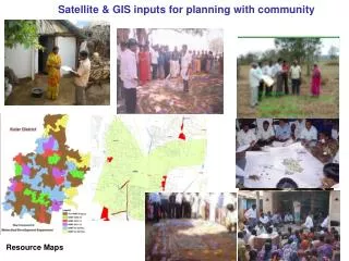
Satellite & GIS inputs for planning with community PRA Field Survey Resource Maps
Private Land Activities Planned under MGNREGS for Renovation and Repair of water Harvesting Structures IWMP NET Planning Software 3
Private Land Activities Planned under IWMP Report IWMP NET Planning Software 4
Category wise Equity Analysis Report IWMP NET Planning Software 6
Caste wise Equity Analysis Report IWMP NET Planning Software 7
WHAT CAN BE SEEN FROM SATELLITE IMAGES? A typical example showing Watershed Boundary overlaid Georeferenced project map overlay on Google Earth...


