Download
1 / 20
200 likes | 343 Views
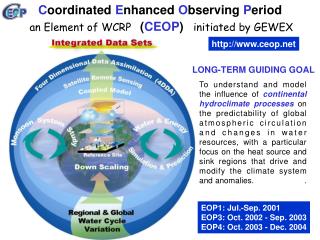
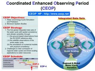
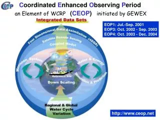
C oordinated E nhanced O bserving P eriod ( CEOP ). an Element of WCRP. initiated by GEWEX. EOP1: Jul.-Sep. 2001 EOP3: Oct. 2002 - Sep. 2003 EOP4: Oct. 2003 - Dec. 2004. http://www.ceop.net. CEOP SCIENTIFIC OBJECTIVES. LONG-TERM GUIDING GOAL To understand and model

E N D
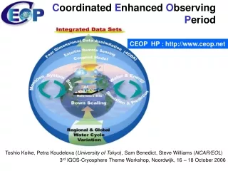
Coordinated Enhanced Observing Period (CEOP) an Element of WCRP initiated by GEWEX EOP1: Jul.-Sep. 2001 EOP3: Oct. 2002 - Sep. 2003 EOP4: Oct. 2003 - Dec. 2004 http://www.ceop.net
CEOP SCIENTIFIC OBJECTIVES LONG-TERM GUIDING GOAL To understand and model the influence of continental hydroclimate processes on the predictability of global atmospheric circulation and changes in water resources, with a particular focus on the heat source and sink regions that drive and modify the climate system and anomalies. OVERALL OBJECTIVE 2 Document the seasonal march of the monsoon systems, assess their living mechanisms, and investigate their possible physical connections. CEOP Intern-Monsoon Study (CIMS) OVERALL OBJECTIVE 1 To better document and simulate water and energy fluxes and reservoirs over land on diurnal to annual temporal scales and to better predict these on temporal scales up to seasonal for water resources application. Water & Energy Simulation & Prediction (WESP)
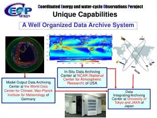
Coordinated Enhanced Observing Period Three Unique Capabilities Convergence of Observations A Prototype of the Global Water Cycle Observation System of Systems
In-Situ Data Archiving Center at NCAR (National Center for Atmospheric Research) of USA Model Output Data Archiving Center at the World Data Center for Climate,Max-Planck Institute for Meteorology of Germany Data Integrating/Archiving Center at University of Tokyo and JAXA of Japan Coordinated Enhanced Observing Period Three Unique Capabilities Interoperability ArrangementA well organized collecting, processing, storing, and disseminating shared data, metadata and products
In-Situ Data Archiving Center at NCAR (National Center for Atmospheric Research) of USA Model Output Data Archiving Center at the World Data Center for Climate,Max-Planck Institute for Meteorology of Germany Data Integrating/Archiving Center at University of Tokyo and JAXA of Japan Coordinated Enhanced Observing Period Three Unique Capabilities Interoperability ArrangementA well organized collecting, processing, storing, and disseminating shared data, metadata and products
GrADS/ DODS for Subsets GrADS/ DDDS for Subsets Distributed Integration Services NCAR Computing Power In-situ model In-situ model In-situ model Centralized Integration Services In-situ In-situ In-situ model In-situ model http://jaxa.ceos.org/wtf_ceop/ MPI GrADS/ DODS for Subsets model http://monsoon.t.u-tokyo.ac.jp/ceop-dc/ceop-dc_top.htm satellite satellite satellite satellite UT/JAXA Computing Power satellite satellite satellite Coordinated Enhanced Observing Period Three Unique Capabilities Data ManagementDistributed- and Centralized- Data Integration Functions
SCIENTIFIC ACTIVITIES OF CEOP PHASE1 SCIENTIFIC ACTIVITIES OF CEOP PHASE2 MODEL OUTPUT REFERENCE SITES REFERENCE BASINS SATELLITES Global Regional Local Diurnal Intra-seasonal Seasonal DATA INTEGRATION & DISSEMINATION WATER & ENERGY SIMULATION & PREDICTION (WESP) Water and Energy Budget Studies Global Land Data Assimilation Systems Inter-CSE Transferability Study Semi-arid Region Study Cold Region Study CEOP INTER-MONSOON STUDY (CIMS) Coordinated Model Integration Process Monsoon System Inter Comparison Aerosol - Monsoon Water Cycle Interaction CEOP Analyses Intercomparison Project Extreme Events Impact Analysis Project Down Scaling 2007-2010: Implementation of New Activities 2005-2006: Completion of Phase1 Preparation for New Activities Watershed Hydrology Study Water Resources Study
GHP-CEOP -evolutional transition- A new ‘science’ – ‘data infrastructure’ coordination body for continental hydroclimate science. Functions of scientific coordination panel, observation convergence, interoperability arrangement, and data management . Science oversight by GEWEX and data management oversight by WOAP. Once a year meeting on science coordination, planning, and project implementation. Coordinated Energy & Water CycleObservation Project (CEOP)
GEWEX MAHASRI CSEs Down Scaling Watershed Hydrology Study Water Resources Study MODEL OUTPUT REFERENCE SITES REFERENCE BASINS SATELLITES Global Regional Local Diurnal Intra-seasonal Seasonal DATA INTEGRATION & DISSEMINATION WATER & ENERGY SIMULATION & PREDICTION (WESP) Water and Energy Budget Studies Global Land Data Assimilation Systems Regional Climate Models Semi-arid Region Study Cold Region Study Stable Water Isotope Intercomparison CEOP INTER-MONSOON STUDY (CIMS) Coordinated Model Integration Process Monsoon System Inter Comparison Aerosol - Monsoon Water Cycle Interaction CEOP Analyses Intercomparison Project Extreme Events Impact Analysis Project HAP COORDINATED ENERGY & WATER CYCLE OBSERVATION PROJECT (CEOP)
GEWEX WCRP WMP WOAP CEOP • Hydroclimate Science • Regional Hydroclimate Projects • CPPA, LBA, LPB, BALTEX, AMMA, MAHASRI, MDB, NEESPI* • Working Groups • WEBS, EEIAP, SWING, CAIP, GLDAS, RCMS, CMIPS, MSIC, AMWCI, SAS,CRS, HAP • Infrastructure for Hydroclimate Science Data • Data Management • Reference Sites/Basins, Satellite Remote Sensing, Model Output • Data Integration&Dissemination • U. Tokyo, WTF-CEOP NWP CEOS IGOS Integrated Global Water Cycle Observations GEOSS
Water & Energy Simulation & Prediction Data Infrastructure Analysis Intercomparison Hydrology Application Extremes cross-cutting Inter-Monsoon Study Evolutional Transition to ‘CEOP’ scientific benefits CSEs Going Forward societal benefits
Global Earth Observation System of Systems Toshio Koike The University of Tokyo
The 10-Year Implementation Plan Vision for GEOSS The vision for GEOSS is to realize a future wherein decisions and actions for the benefit of humankind are informed by coordinated, comprehensive and sustained Earth observations and information.
Three Meanings of “A System of Systems” A System for Integrating Observation, Modeling, and Data Management Systems Disaster Health Energy Climate Weather A System for Coordinating the Nine Socio Benefit Areas Water Agriculture A System for Converging Observation Systems Worldwide Biodiversity Ecosystem
GEOSS/Asian Water Cycle Initiative[integration of earth observation data] + [capacity development] programme *GEOSS Implementing Agencies (observations, predictions, data integration) Integration and use of earth observation data Satellite data, global network data, numerical forecasting model, assimilation of data Capacity Building Area data / information In-situ data In-situ data In-situ data In-situ data use of satellite data *Space Agencies Research obs, Modeling andanalysis *UNU, universities Research Institute, etc. In-situ observation River management *ICHARM, MRC ESCAP, etc. Common items Basin 1 Basin 2 Basin 3 Basin 4