Download
1 / 44
592 likes | 1.35k Views
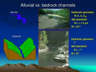
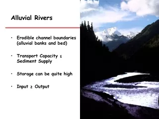
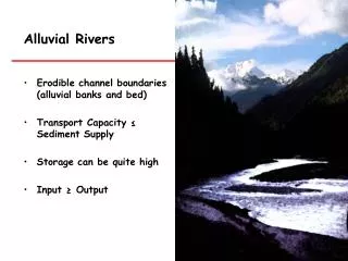
Alluvial Rivers Erodible channel boundaries (alluvial banks and bed) Transport Capacity ≤ Sediment Supply Storage can be quite high Input ≥ Output. Importance of alluvial rivers. Rivers: Provide water and nutrients for agriculture Provide habitat to diverse flora and fauna

E N D
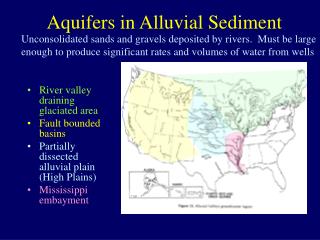
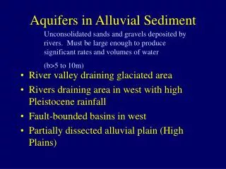
Alluvial Rivers • Erodible channel boundaries (alluvial banks and bed) • Transport Capacity ≤ Sediment Supply • Storage can be quite high • Input ≥ Output
Importance of alluvial rivers Rivers: • Provide water and nutrients for agriculture • Provide habitat to diverse flora and fauna • Provide routes for commerce • Provide recreation • Provide electricity
Bankfull Discharge Typically bankfull discharge equates to a roughly 2-year recurrence interval flow.
Channel Patterns Three basic map-pattern forms of streams: • Straight • Meandering • Braided
STRAIGHT CHANNELS • Straight channels are rare. • Straight channels form where streams are confined by topography or follow geologic structures. • Generally mountains streams.
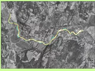
Streams generally erode on outer (cut) banks where velocity is greatest, and deposit on the inner sides of bends where velocity is slower. Meanders tend to grow as the flow erodes the banks, favoring development of meandering channels.
Meandering channels Loops or meanders form as stream erodes its banks. Erosion takes place on the cut bank, which is the outside loop of the meander. Deposition takes place on the point bar, which is on the inside loop of the meander.
Meandering channels Change their channel course gradually Create floodplains wider than the channel • Very Fertile soil • Subjected to seasonal flooding
Meandering channels Cut Banks Point Bars
Meandering streams often characterized by large loopy bends across their floodplains. • Meanders occur most commonly in channels that lie in fine-grained stream sediments and have gentle gradients.
Growing meanders can intersect each other and cut off a meander loop, forming an oxbow lake.
Old channels abandoned as a river meanders across its floodplain form oxbows. Oxbow lake
Meander “train” = belt of meandering Owens River, CA Sacramento River, CA
Note old meanders Owens River, CA Sacramento River, CA
Meander “train” = belt of meandering Meander belt Meander belt Channel migration zone = area across which the river is prone to move.
Pool - riffle sequence Riffle to riffle = 5 - 7 channel widths
Riffles, pools, and cascades Riffles and pools alternate in somewhat predictable patterns
BRAIDED CHANNELS Many converging and diverging streams separated by gravel bars (or sand bars).
Braided Streams • High sediment load • Anastamosing channels • Constantly changing course • Floodplain completely occupied by channels • Many small islands called mid-channel bars • Usually coarse sand and gravel deposits.
Braided Channels • If a stream is unable to move all the available load, it tends to deposit the coarsest sediment as a bar that locally divides the flow. • Braided channels tends to form in streams having highly variable discharge, easily erodible banks, and/or a high sediment load.
Braided Channels • Glacial streams generally are braided because: • The discharge varies both daily and seasonally. • The glacier supplies the stream with large quantities of sediment.
Braided channels clog themselves with sediment, so channels always shifting • Generally in streams near mountain fronts
Variability in river systems • Four dimensions: • Longitudinal • Lateral • Vertical • Time The four dimensions of a stream system
Variation in time and space The shape, size and content of a river are constantly changing, forming a close and mutual interdependence between the river and the land it traverses.
Small meanders high gradient coarse substrates Big meanders low gradient fine substrates Sinuosity: Gradient and substrate
Channel type • Bedrock • Colluvial • Alluvial • A. Cascade • B. Step-pool • C. Plane-bed • D. Pool & riffle • E. Dune – ripple
Colluvial Channels Small headwater channels at the tips of the channel network where sediment transport is dominated by landslide processes.
Cascade Channels The steepest of mountain channels, characterized by tumbling flow around individual boulders; disorganized streambed structure.
Step-Pool Channels pools Channels displaying full-width-spanning accumulations of coarse sediment that forms a sequence of steps. steps
Plane-Bed Channels Channels lacking well-defined bedforms and instead displaying long reaches lacking pools.
Pool-Riffle Channels The most common mountain river morphology; characterized by alternating sequence of pools and bars. pools bars