Download
1 / 28
280 likes | 419 Views
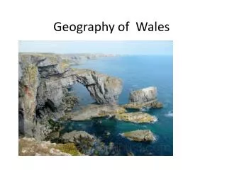
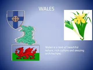
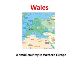
Pieces of Wales. A guide to the sum of its parts. Created by Swansea Jack - 2013. WALES. That is what Wales looks like from satellites far above the earth – devoid of any artificial boundaries – pure Wales ! But how was / is our Nation subdivided?.

E N D
Pieces of Wales A guide to the sum of its parts Created by Swansea Jack - 2013
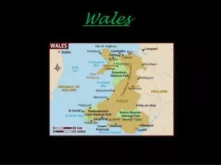
That is what Wales looks like from satellites far above the earth – devoid of any artificial boundaries – pure Wales! But how was / is our Nation subdivided?
There had been many boundaries in its earlier history, with ancient tribal areas occupied by the Ordivices and the Silures (to name just two), and many kingdoms that came - and went. But here is a simple look at three sets of more modern boundaries.
The ‘Historic’ Counties The ‘Preserved’ Counties The ‘Principal Areas’ (of local government) Each section contains maps and numbered web-links for further research. The numbers in those maps are also used in the cross-tabulations that follow.
The ‘Historic’ Counties It is now accepted that there are 13‘Historic’ Counties of Wales. Well there were the odd disputes as to whether Monmouthshire was, or should be, a part of Wales. That can be delved into elsewhere. Suffice it to say, when I learned geography in school (1950s and 1960s) – we learned there were 12 ‘real’ Counties and one (Monmouthshire) that was considered Welsh when we wanted - or needed it to be so - and English when that served our purpose better! http://en.wikipedia.org/wiki/Historic_counties_of_Wales
The ‘Historic’ Counties See key to names / numbers on next slide.
The ‘Historic’ Counties - and urls 1 Anglesey (Sir Fôn) http://en.wikipedia.org/wiki/Isle_of_Anglesey 2 Brecknockshire (Sir Frycheiniog) http://en.wikipedia.org/wiki/Brecknockshire 3 Caernarfonshire (Sir Gaernarfon) http://en.wikipedia.org/wiki/Caernarfonshire 4 Cardiganshire (Sir Aberteifi or Ceredigion) http://en.wikipedia.org/wiki/Ceredigion 5 Carmarthenshire (Sir Gaerfyrddin) http://en.wikipedia.org/wiki/Carmarthenshire 6 Denbighshire (Sir Ddinbych) http://en.wikipedia.org/wiki/Denbighshire_(historic) 7 Flintshire (Sir y Fflint) http://en.wikipedia.org/wiki/Flintshire_(historic) 8 Glamorganshire (Sir Forgannwg) http://en.wikipedia.org/wiki/Glamorgan 9 Merionethshire (Sir Feirionnydd) http://en.wikipedia.org/wiki/Merionethshire 10 Monmouthshire (Sir Fynwy) http://en.wikipedia.org/wiki/Monmouthshire_(historic) 11 Montgomeryshire (Sir Drefaldwyn) http://en.wikipedia.org/wiki/Montgomeryshire 12 Pembrokeshire (Sir Benfro) http://en.wikipedia.org/wiki/Pembrokeshire 13 Radnorshire (Sir Faesyfed) http://en.wikipedia.org/wiki/Radnorshire
The ‘Preserved’ CountiesThrough a combination of accretion and division (the new math?), 13 counties became 8. Some were ‘absorbed’ or combined – in whole, or in part – to form ‘new’ counties, while others were divided into smaller counties. Some consider there to be only 6 in number – you may often see maps in which one (Glamorgan - numbered 2,3 and 4 on the following map) is not subdivided.http://en.wikipedia.org/wiki/Preserved_counties_of_WalesFollowing the map of the ‘Preserved’ Counties - are links to each.
The ‘Preserved’ Counties See key to names / numbers on next slide.
The ‘Preserved Counties’ – and urls • 1. Gwenthttp://en.wikipedia.org/wiki/Gwent_(county) • 2. South Glamorganhttp://en.wikipedia.org/wiki/South_Glamorgan • 3. Mid Glamorganhttp://en.wikipedia.org/wiki/Mid_Glamorgan • 4. West Glamorganhttp://en.wikipedia.org/wiki/West_Glamorgan • 5. Dyfedhttp://en.wikipedia.org/wiki/Dyfed • 6. Powyshttp://en.wikipedia.org/wiki/Powys • 7. Gwyneddhttp://en.wikipedia.org/wiki/Gwynedd • 8. Clwydhttp://en.wikipedia.org/wiki/Clwyd
The ‘Principal Areas’The reduction from 13 ‘Historic’ Counties to 8 ‘Preserved’ Counties was unsatisfactory to some – but of necessity, given the nature of the population distribution in Wales. The more populous North-East and South-East areas naturally underwent subdivision – such that there are now 22 ‘Principal Areas’ – for local government purposes. Their boundaries sometimes follow geographic lines that are different from parts of the boundaries of the ‘Historic’ and the ‘Preserved’ Counties - and most likely the result of some ‘Taffymandering’! http://en.wikipedia.org/wiki/Local_government_in_Wales
The ‘Principal Areas’ See key to names / numbers on next slide.
The ‘Principal Areas’ – and urls 1 Merthyr Tydfil (Merthyr Tudful) http://en.wikipedia.org/wiki/Merthyr_Tydfil 2 Caerphilly (Caerffili) http://en.wikipedia.org/wiki/Caerphilly_(county_borough) 3 Blaenau Gwenthttp://en.wikipedia.org/wiki/Blaenau_Gwent 4 Torfaen (Tor-faen) http://en.wikipedia.org/wiki/Torfaen 5 Monmouthshire (Sir Fynwy) http://en.wikipedia.org/wiki/Monmouthshire 6 Newport (Casnewydd) http://en.wikipedia.org/wiki/Newport 7 Cardiff (Caerdydd) http://en.wikipedia.org/wiki/Cardiff 8 Vale of Glamorgan (Bro Morgannwg) http://en.wikipedia.org/wiki/Vale_of_Glamorgan 9 Bridgend (Pen-y-bont ar Ogwr) http://en.wikipedia.org/wiki/Bridgend_(county_borough) 10 Rhondda Cynon Tafhttp://en.wikipedia.org/wiki/Rhondda_Cynon_Taf 11 Neath Port Talbot (Castell-nedd Port Talbot) http://en.wikipedia.org/wiki/Neath_Port_Talbot 12 Swansea (Abertawe) http://en.wikipedia.org/wiki/Swansea 13 Carmarthenshire (Sir Gaerfyrddin) http://en.wikipedia.org/wiki/Carmarthenshire 14 Ceredigionhttp://en.wikipedia.org/wiki/Ceredigion 15 Powyshttp://en.wikipedia.org/wiki/Powys 16 Wrexham (Wrecsam) http://en.wikipedia.org/wiki/Wrexham_(county_borough) 17 Flintshire (Sir y Fflint) http://en.wikipedia.org/wiki/Flintshire 18 Denbighshire (Sir Ddinbych) http://en.wikipedia.org/wiki/Denbighshire 19 Conwyhttp://en.wikipedia.org/wiki/Conwy_(county_borough) 20 Gwyneddhttp://en.wikipedia.org/wiki/Gwynedd 21 Isle of Anglesey (Ynys Môn) http://en.wikipedia.org/wiki/Isle_of_Anglesey 22 Pembrokeshire (Sir Benfro) http://en.wikipedia.org/wiki/Pembrokeshire
The ‘Principal Areas’ The ‘Principal Areas’ - with some of the main towns
Cross tabulationsThe following 6 tables (in 3 pairs) show how a ‘County’ or ‘Area’ in one ‘set’, fits into – or combines with – others. [In some instances, a different name spelling may be used to identify the same area. The colors are simply to aid in viewing the entities within a paired set – and may NOT always be that same (or any) color in another paired set.]In each pair; the second table is a reciprocal of the first. The pairs are:A. 1. ‘Historic’ versus ‘Preserved’; 2. ‘Preserved’ versus ‘Historic’B. 1. ‘Historic’ versus ‘Principal’; 2. ‘Principal’ versus ‘Historic’C. 1. ‘Preserved’ versus ‘Principal’; 2. ‘Principal’ versus ‘Preserved’
In each pairing, the first table (1) shows what percentage of the area named in the left column is within the area named in the right column. The second table (2) shows whatpercentage of the area named in the left column is comprised of the area named in the right column.
View the following slides with Caernarfonshire * as the example: * [ Blue background, Map # 3 ] In Table A1(‘Historic’ versus ‘Preserved’), 80% of Caernarfonshire(Map #3 – in left column)is withinGwynedd(Map #7)and 20% is withinClwyd (Map #8)– each in right column. In Table A2(‘Preserved’ versus ‘Historic’),Caernarfonshire(Map #3 – in right column)is seen to comprise 35% of Gwynedd(Map #7)and 18% of Clwyd (Map #8)– each in left column.
In Table B1(‘Historic’ versus ‘Principal’): 80% of Caernarfonshire(Map #3 – in left column)iswithin Gwynedd (Map # 20) and 20% is withinConwy (Map #19) – each in right column.In Table B2(‘Principal’ versus ‘Historic’):Caernarfonshire(Map #3 – in right column) is seen to comprise 35% of Conwy (Map #19) and 47% of Gwynedd (Map # 20) - each in left column. . . . Continuing . . .
Need a break? Don’t confuse Clwyd (in Tables A1 and A2) with Conwy (in Table B1 and/or Conwy (in Table B2) - Conwy is only a part (35%) of Clwyd - see Table C1 and Table C2A word from the Welshto the English : Chwarae teg![It means ‘Fair play !]You are doing well if you are keeping up !
Paired tables C1 and C2 C2
Thank you very much ! Diolch yn fawr !