Download
1 / 2
20 likes | 120 Views
This document outlines the significant challenges and opportunities related to data assimilation from GOES-R, particularly for storm-scale prediction. Key issues include high time-resolution data capture, cloud information assimilation, and merging data from various sources like radar. Recommendations emphasize the untapped potential of hyperspectral IR sensors, satellite winds, and improving height assignments. Further research is urged in direct assimilation of imagery data, utilizing non-traditional data sources, and model impact studies to validate and enhance GOES-R benefits for severe weather forecasting.

E N D
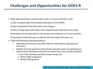
Challenges and Opportunities for GOES-R • Major data assimilation issues for storm scale (1-5 inputs from Steve Lord):1) How to capture high time resolution data (such as from GOES)2) How to assimilate cloud information from imagery 3) How to merge above information with complementary information from radar4) Development of model systems that simulate storm behavior at 1-2 km resolution5) Reanalysis of historical cases to calibrate skill and support forecaster use • JCSDA-HFIP Workshop Recommendations: • Hyperspectral IR sensors (e.g. AIRS, IASI) are underutilized, especially near hurricanes. • Satellite winds are generally underutilized; especially rapid-scan geostationary winds contain information about the circulation that is not currently exploited. • Learn from the Navy experience (super-obing, QC) • Better height assignment • Nested tracking winds With input from Tim Schmit, Steve Lord, Lars Peter Riishojgaard
Challenges and Opportunities for GOES-R • How do we truly exploit the high time resolution of GOES/GOES-R, EnKF, 4D-VAR? etc. • Research on direct assimilation of imagery data, building on and expanding the current experience with model-simulated satellite images • Research on data assimilation use of non-traditional data (e.g. lightning, precipitation) • How do we best use cloudy radiances? • How to assimilate GOES-R products and data into the Hybrid Variational ensemble model at 1 km and 10 km? • How do we best use GOES images/products to VALIDATE (or tune the models)? • What model impact studies are of highest priority to determine GOES- R benefit? • What metrics are most appropriate and useful ? • Storm track and timing of intensity/severity • What verification methodologies are most appropriate and useful ? • Refer to WMO Joint WWRP/WGNE Working Group on Forecast Verification Research • What are the attributes of a High Impact Weather OSSE for a geostationary sounder