Download
1 / 15
150 likes | 318 Views
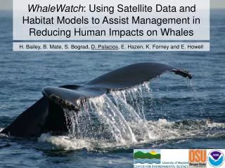
WhaleWatch : Using Satellite Data and Habitat Models to Assist Management in Reducing Human Impacts on Whales. H. Bailey, B. Mate, S. Bograd , D. Palacios , E. Hazen, K. Forney and E. Howell. Outline. Goals Approach Satellite telemetry data Remotely sensed environmental data

E N D
WhaleWatch: Using Satellite Data and Habitat Models to Assist Management in Reducing Human Impacts on Whales H. Bailey, B. Mate, S. Bograd, D. Palacios, E. Hazen, K. Forney and E. Howell
Outline • Goals • Approach • Satellite telemetry data • Remotely sensed environmental data • Preliminary blue whale habitat model results • Transition to the partner • Next steps
Goals • Use satellite data to develop habitat models that will allow us to identify large whale hotspots and provide a tool for predicting occurrence in the California Current System. This will assist management efforts to mitigate against human impacts.
Approach • Apply a state-space model to provide regularized daily positions from whale satellite telemetry data • Develop habitat preference models using RS data • Identify hotspots for blue, fin, humpback, and gray whales • Develop a new decision support tool for NOAA that can predict the probability of whale occurrence
Whale Satellite Telemetry Data Whale species: Blue Fin Humpback Gray No. tags: 128 2 15 35 Years: 1993-2008 2004, 2006 2004-2005 2005, 2009
Ecological Considerations • BWs depend exclusively on dense krill aggregations for food and must forage constantly • BW large-scale distribution must be dictated by regions where krill patches reliably develop and can be exploited • A simple ‘upwelling-diatoms-krill’ food chain creates these conditions. This pathway has a predictable large-scale environmental mechanism. • BWs should focus their ARS behavior in these regions and therefore large-scale blue whale movement behavior should be predictable on the basis of environment.
Specify response variable & account for position error Formulate hypotheses linking whale movement behavior to krill aggregation mechanisms & specify relevant environmental covariates Run NPMR models on gridded & stratified data by province and season Assess model skill with validation data set Extend prediction to full region (NE Pacific) Blue Whale Habitat Modeling
CALIFORNIA CURRENT – SUMMER/AUTUMN BSTATE ~DEPTH xEASTNESS xSSH xWEKMN xPP xR2 = 0.302, N = 282 Preliminary Results
Conclusions • ARS behavior was most intense and extensive on the shelf over westward facing slopes, suggesting that topographic features are good predictors of krill aggregation. • Oceanographic conditions associated with most intense ARS included a high primary productivity, low SSH, and positive WEKMN. • The likelihood of foraging behavior in response to environmental variables was captured by hump-shaped or otherwise nonlinear functions • These responses indicate that blue whales optimize foraging behavior along environmental gradients, making it a useful measure of ecological performance
Partner and Transitioning • The habitat models will be developed into a tool, “WhaleWatch”, and transitioned to the partner NOAA/NMFS Southwest Regional Office to provide information on whale distribution and hot spots. • This will assist with their efforts to establish policies to reduce the number of ship strikes and whale entanglements. • The WhaleWatch tool will also be hosted on the NOAA website to benefit other agencies and stakeholders.
Next Steps • Meet with partner and other stakeholders to determine requirements for WhaleWatch tool and how it can best assist management • Complete application of state-space model to all whale tracks • Complete blue whale habitat model and assessment of most appropriate modeling techniques
Acknowledgements • Funding was provided under the interagency NASA, USGS, National Park Service, US Fish and Wildlife Service, Smithsonian Institution Climate and Biological Response program, Grant Number NNX11AP71G. • Dave Foley provided useful discussions about the data sets served by Coastwatch. • The support of field crews was essential to the success of the tagging operations. Tagging was supported by private donors to the MMI Endowment at OSU, as well as the support from ONR and the Sloan, Packard and Moore foundations to the TOPP program.