Aerial Photography Worksheet Templates for Aircraft Mapping Patterns
80 likes | 95 Views
This comprehensive resource provides detailed worksheet templates for various aerial photography patterns used in aircraft mapping, covering circling, overview, birdseye, and square patterns. Included are guidelines for altitude, airspeed, weather, obstacles, and camera setup to ensure accurate image capture. The instructions emphasize safety and precision for successful aerial data collection.

Aerial Photography Worksheet Templates for Aircraft Mapping Patterns
E N D
Presentation Transcript
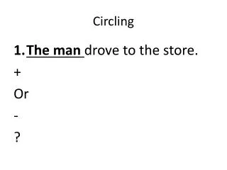
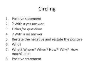
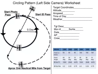
Circling Pattern (Left Side Camera) Worksheet Target Coordinates______________ Altitude__________ Airspeed________ Time of Day___________________ Weather______________________ Start Photo Pass Start ID Pass Tgt Desc______________ Msn #______Sortie______ Date_______________ AP________________ Crew______________ S Dist Aprox One Nautical Mile from Target
Circling Pattern (Right Side Camera) Worksheet Target Coordinates______________ Altitude__________ Airspeed________ Time of Day___________________ Weather______________________ Obstacles_____________________ Start ID Pass Start Photo Pass Tgt Desc_________________ Msn #______Sortie________ Date_____________________ AP______________________ Crew_____________________ S Approx One Nautical Mile from Target
Overview (Birdseye) Pattern (Left Side Camera) Worksheet Target Coordinates______________ Altitude__________ Airspeed________ Time of Day___________________ Weather______________________ Obstacles_____________________ Start ID Pass Tgt Desc__________________ Msn #______Sortie__________ Date______________________ AP________________________ Crew______________________ S 0.1Nm Note: Rule for Congested Areas: 1000’ Above and 2000’ Horizontal from the highest Obstacle. Circle target to find the Altitude that permits horizontal framing and determine best direction to take the Photo. Keep Camera Nearly Perpendicular to Window while Aircraft Banks. Avoid imaging A/C Wing or Landing Gear Start Photo Pass Start Circle to Determine Best Angle Approx ½ Nautical Mile from Target
Overview (Birdseye) Pattern (Right Side Camera) Worksheet Target Coordinates______________ Altitude__________ Airspeed________ Time of Day___________________ Weather______________________ Obstacles_____________________ Start ID Pass Tgt Desc__________________ Msn #______Sortie__________ Date______________________ AP________________________ Crew______________________ S 0.1Nm Note: Rule for Congested Areas: 1000’ Above and 2000’ Horizontal from the highest Obstacle. Circle target to find the Altitude that permits horizontal framing and determine best direction to take the Photo. Keep Camera Nearly Perpendicular to Window while Aircraft Banks. Avoid imaging A/C Wing or Landing Gear Start Photo Pass Start Circle to Determine Angle Approx ½ Nautical Mile from Target
4 Square Pattern (Left Side Camera) Worksheet Target Coordinates______________ Altitude__________ Airspeed________ Time of Day___________________ Weather______________________ Obstacles _____________________ Start ID Pass North Side Latitude ________________________ Tgt Desc______________ Msn #______Sortie__________ Date______________________ AP________________________ Crew______________________ West Side Longitude ________________________ East Side Longitude ________________________ S Start Photo Pass South Side Latitude ________________________ End Photo Pass
4 Square Pattern (Right Side Camera) Worksheet Target Coordinates______________ Altitude__________ Airspeed________ Time of Day___________________ Weather______________________ Obstacles _____________________ Start ID Pass North Side Latitude ________________________ Tgt Desc______________ Msn #______Sortie__________ Date______________________ AP________________________ Crew______________________ West Side Longitude ________________________ East Side Longitude ________________________ S Start Photo Pass South Side Latitude ________________________ End Photo Pass
4-Square Aerial Photography Pattern – Aircraft Turn Procedures at Corners Assumptions: 90 Knot ground speed (1 & ½ nm per minute) All turns – standard rate Assuming No Wind corrections At the corner point, fly straight for 20 seconds (1/2 nm) Start right standard rate turn for 30 seconds Fly Straight for 60 seconds (1 & ½ nm) Start Right standard rate turn for 60 seconds (1nm) Adjust final run-in for correct Latitude and Longitude and heading for next pass 1 & ½ nautical mile 60 seconds at 90 Knots) 30 Sec Turn ½ nautical mile (20 seconds at 90 Knots) 60 Sec Turn Standard Rate Turn Use this leg to accurately line up the next track around the four square pattern
Overview (Strip) Pattern (Left Side Camera) Worksheet Used for Strip Photography (Like long straight Roads or along the Beach) and Wide Aerial Mapping projects Speed 90 Kts Altitude Options 1200’ or 2400’AGL Camera Focal Length 50mm, 100mm Camera Angle 45 Degrees, Setup with Angle Template and stabilized Tripod Timing of Images for desired % Overlap at 90 Kts and desired Altitude. Use Camera Timer for Sequential Shots Mapping Patterns (East to West) with Pattern Offset for Mapping Overlap. For Beaches 1/3 Water, 2/3 Land in Shot Set up for Computer Image download and image view on computer screen