Download
1 / 49
490 likes | 636 Views
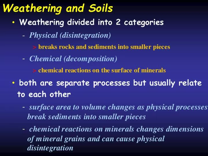
Volume to surface area ratios. •. Chemical weathering works on the surface. Smaller particle sizes (in. a given volume) have greater surface area for chemical weathering. Decomposition (chemical weathering). Geochemical weathering. •. -. inorganic chemical reactions. -.

E N D
Volume to surface area ratios • Chemical weathering works on the surface. Smaller particle sizes (in a given volume) have greater surface area for chemical weathering.
Decomposition (chemical weathering) Geochemical weathering • - inorganic chemical reactions - causes rock to get "rotten" while still preserving many of the original structures created during formation of the rock Creates a bedrock residuum called a Saprolite • Water is most important element • - facilitates transfer of chemical elements and chemical reactions - + > water often dissociates into OH and H which then acts on electrically imbalanced surfaces on mineral grains
Abrasion pH change in pH of water (or other fluids) by powdering a mineral and placing in water • - related to ion exchange, and reaches a steady state Gives a measure of how effective water is at weathering any given mineral- implies a steady state condition is reached H+ is depleted, OH- is enriched relative to H+ • Implication is that the reactions can achieve • some initial maximum rate and extent and then the rates drop off considerably
Etching related to chemical weathering acting and • pieces breaking off along cleavage surfaces - keeps rates from achieving some steady state
processes of chemical weathering Oxidation/Reduction • - a function of available free oxygen and the Eh (redox potential) - Oxygen strips electrons away from other atoms the process is reversible • - often related to water levels in streams and groundwater systems
chemical processes Hydrolysis • - reactions between a salt and water > produces Acids and Bases - H ions replace metallic elements (K in the example below) - reaction continues until all H atoms have been used up 2KAlSi O + 2H + 9H O H Al Si O + 4H SiO + 2K • 3 8 2 4 2 2 9 4 4 orthoclase kaolinite feldspar
Soil Characteristics • What is a soil? • naturally occurring 4 dimensional feature (Up/Down; Left/Right; Front/Back; Time) • Consists of layers or horizons that parallel the earth’s surface • Layers have distinctive mineralogical, chemical, particle size composition that are a function of pedogenesis acting on the parent material • Consists of unconsolidated materials* • * some horizons act like lithified materials though • Some include capable of supporting plant life
Factors influencing soil development • They are the same things that influence weathering • Climate • Temperature and moisture • Parent Material • Influences mineral content • Topography • Includes elevation, slope and aspect • Vegetation • Dependent on temperature and climate • Time • Take time for mechanical and chemical processes to occur
Development with time most factors develop with time • - not a steady process though- rates of change vary with time.
Use of soils Relative age tool • - Must isolate all variables to address the effects time Stratigraphic tool • - represents former land surface Paleoenvironmental tool • - certain soil orders only occur in limited climates > e.g., aridisol, vertisol - certain characteristics develop best in restricted climates
Soil Profile • The vertical arrangement of the soil from the surface to the parent material • Soils take isotropic materials like basalt or as or quartzite and make them anisotropic at the surface The soil profile follows the landscape, and when conditions warrant, cuts across existing strata
Pedon • The 3 dimension version of a soil profile. It typically includes an areal dimension lacking in the soil profile • This is needed to describe the lateral variability in soils within a given region • Pedon is the fundamental mappable unit in soil science • The pedon is not able to be photographed, and is commonly poorly described by researches due to time and monetary constraints.
The Weathering Profile In areas with extensive moisture and or extensive permeability, weathering extends very deep primarily in the form oxidation and reduction The soil profile is the uppermost part of the weathering profile The weathering profile may be only as thick as the soil profile in many circumstances
Master Horizons - O (organic) • Common in areas with high biological productivity • Typically black or dark brown • Usually thin, but can be quite thick • Can indicate continued deposition if very thick • cumulic O horizon • Can look like A-Horizon O
Ob-horizon • Commonly, a lab analysis is needed to distinguish between A and O horizons • O is more than 30% organics • A is less than 30%
Master Horizons - A • Dark in color • often black • Doesn’t have to be • Mineral content dominant • Can be quite thick • Zone of eluviation • Often difficult to differentiate between A and O horizons
A 2Bt1 3Bt2
Master Horizons E-Horizon Zone of extreme leaching of minerals- eluviation Bleached- a gray color below the A/O horizons but above the B Primary minerals provide color- rest has been washed away Common under conifer forests and grasslands
Master Horizons B-Horizon Zone of Illuviation Clays and chemicals collect in this horizon Typically marks the average depth of wetting front
Master horizons K-Horizon Occurs at the base of the B-horizon Common in arid environments Depth of wetting front determines location Caliche creates an impermeable zone like concrete K horizon
Master Horizons C-horizon Slightly altered parent materials Typically oxidized only Recognizable as parent material
Master Horizons - subordinate designations (1-3) “b” is the most common one of these 5 designations They appear immediately after the Master Horizon designation and are always lower case
Master Horizons - subordinate designations (2-3) “k” is the most common of these designations “ss” commonly occurs in areas with shrink-swell clays like smektite (e.g., Texas Gulf Coast).
Master Horizons - subordinate designations (3-3) “x” commonly designates a fragipan, a dense brittle horizon that slakes in water, but is impermeable otherwise.
Soil Description • 1- Clear off a face so that the color changes are easily viewable • Natural light is best; colors can be very subtle • 2- Mark any locations where the color changes • Golf tees work great (expensive), as do plastic toothpicks (cheap) • 3- Use your dirt knife and start poking the soil gently moving down from the top • Feel for changes in the resistance to the “poke” and mark where it changes (except where the change coincides with already marked locations • 4- Stretch a tape measure and record the intervals between the markers (from the top to the bottom) • e.g.,0-10 cm; 10-26 cm, etc…
Soil description (continued) • 5- Determine the horizon name for the first layer by describing the following criteria • Color * see specific slide • Structure * see specific slide • Texture * see specific slide • 6- Describe the character of the bottom contact with underlying layers • 7- Look at samples using a hand lens to determine if there are clay films or silt coats • Look in pore spaces and on ped faces • 8- Test with hydrochloric acid solution for reactivity
Characteristics- Color Described using 3 sets of numbers • - Munsell Soil Color Chart First tells the ratio of red to yellow (Hue) • - e.g., 7.5 YR, 5R, 10YR, 2.5YR, 7.5R - these identify on what page you examine the next 2numbers Second tells light vs dark (Value) • - denoted as the numerator of a fraction Third tells the strength of the color • - deviation from a neutral of the same color - the denominator of the fraction
Other factors Calcium Carbonate • Topography of the horizon boundary • - smooth, wavy, irregular Distinctiveness of the boundary • - diffuse, gradual, distinct, abrupt Mottles • - uniformity of color, "blotchiness" Organic matter • and anything else you can see that doesn't fall • into one of the above categories
Lab determinations • Bulk density- • the weight of the soil per unit volume • A measure of how dense the soil is (grams/cm3) • Increases as clay content increases • Coat peds in parafin wax and measure weight in water and weight without wax.
Lab determinations • pH • Take a small sample and mix with DI water. Insert the probe and take a reading • - other methods are available • CEC- Cation Exchange Capacity • Determines the total negative electrical charge on clay surfaces in meq/100 g of soil (milliequivalents) • Calcium Carbonate content • Measured using a chittack apparatus • Particle size • Hydrometer; Pipette; Laser • Carbon • Loss on ignition
Paleosols Soils no longer in the active soil forming environment