Download
1 / 1
10 likes | 112 Views
Learn how the SSEC Data Center facilitates scientific research by providing geophysical data in a timely manner, storage services, and data retrieval. Discover the advanced satellite aviation program and the role of NPP PEATE at SSEC.

E N D
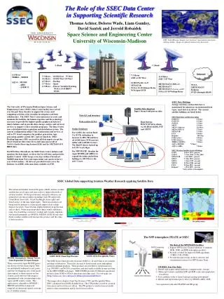
30 30 90 90 150 150 210 210 330 330 450 450 Time Latency (minutes) Time Latency (minutes) C-Band L-Band The Role of the SSEC Data Center in Supporting Scientific Research Thomas Achtor, Delores Wade, Liam Gumley, David Santek and Jerrold Robaidek Space Science and Engineering Center University of Wisconsin-Madison SSEC Global Montage: Imagery uses data from 7 geostationary and 6 polar orbiting satellites. Images are updated whenever new data arrives X-Band 4.4 Meter TERRA – MODIS AQUA – MODIS - AIRS - AMSR -E 7.3 Meter AMC-4 101 West GOES-Pacific (G-9) MTSAT-1R NOAA 15-18 Gilmore Relay NOAAport DVB 11.0 Meter AMC-3 87 West METEOSAT-8 (MSG-1) METEOSAT-7 METEOSAT-5 (X sectors via M7) NOAA 15-18 Wallops Relay 7.3 Meter - GOES-East 75 West 4.6 Meter - GOES-West 135 West 4.5 Meter - Backup 3.7 Meter - Spare 1.2 Meter - Flyover Variable Tracking NOAA 15-18 HRPT FY1D NOAA METEOSAT-5 Kalpana FY2D (through ABoM) SSEC Data Holdings A large real-time, on-line data base is maintained for numerous environmental data types; most data is archived. The current satellite holdings are listed below. The University of Wisconsin-Madison Space Science and Engineering Center (SSEC) Data Center facility has evolved over the past three decades to support the science and computing activities of its scientific investigators and their collaborators. The SSEC Data Center mission is to create and maintain the facilities, the human expertise and the technology necessary to provide the highest quality geophysical data in a timely fashion, and to provide data storage, archive and retrieval services to support Center scientific programs. The Data Center uses a distributed data acquisition and distribution system. The current configuration utilizes Unix workstations and servers, as well as PC based computers for product generation, tape processing, quality control (QC) and serving data. SSEC Desktop Ingestors (SDI) are used for all data ingests except the direct broadcast data from Terra and Aqua spacecraft of NASA’s Earth Observing System (EOS) and the METEOSAT-8 HRIT data. For EOS Direct Broadcast, the SSEC Data Center initiates and monitors the data ingest, archives the Level-0 data, and provides Quality Control. SSEC keeps seven days of direct broadcast MODIS data from Terra and Aqua online (our goal is to have 1 year of data online). All data are provided to users over the Internet via ADDE, with some data available via FTP. Satellite Data Ingestors Ingest, format and process data Data QC and inventory SSEC Real-Time satellite data online GOES-12 6.5 days GOES-10 6.5 days GOES-9 3.5 days MET-7 3.5 days MET-5 ( high res) 22.0 days MET-8 (MSG-1) 2.5 days MTSAT-1R 1.3 days FY2C 4.0 days Kalpana 30.0 days POES (relay) 3.0 days POES (flyover) 2.5 days TERRA (MODIS) 7.0 days AQUA (MODIS) 7.0 days AQUA (AIRS) 7.0 days Data archive LTO-2 Data Servers Data is served to clients via McIDAS ADDE, FTP and HTTP Active table Online Databases For GOES, the current Raid-5 is 50 TB, with plans to increase to 400+ TB and have all GOES data (1978-current) online and available to users, The Raid-5 data is backed up to LTO-3 cartridges. For NPP PEATE, the plan for Aqua MODIS and AIRS is to expand the online global data holdings to 100 TB over the next 3 years. SSEC Weather Satellite Archive Holdings GOES 20 Feb 1978 - present GMS-5 9 Nov 1998 -21 May 2003 MTSAT-1R 5 Jul 2005 - present MET-7 9 Mar 1999 - present MET-5 9 Mar 1999 - present MET-8 25 Mar 2004 - present FY2C 25 Jun 2005 - present Kalpana* 1 Feb 2005 - present *early archive is incomplete SSEC Global Data supporting Aviation Weather Research applying Satellite Data The Advanced Satellite Aviation Program (ASAP) utilizes weather satellite data on all space and time scales to support the needs of aviation weather. Global geostationary and polar radiances are integrated to produce products including 11um TB (upper left), Cloud Mask (lower left), Cloud Top Height (lower right) and Time Latency of the data (upper right). These data products are being used by industry to create greatly improved in-cockpit displays for pilots. Trans-Oceanic flights benefit from global data such as these. Other aviation products depict winds, turbulence, icing, low clouds/fog, convective weather and volcanic eruptions. Advanced instruments on NPOESS, METOP, GOES-R and other future weather satellites will increase the accuracy and the value of these products. The NPP Atmosphere PEATE at SSEC The Role of the NPP PEATE Facilities 1, Support NPP Science Team evaluation of standard RDR, SDR, and EDR atmosphere products 2. Provide a testbed for improved EDR algorithms (VIIRS, CrIS, ATMS) 3. Provide data processing, archive, retrieval, and visualization resources for NPP Science Team Wind Vectors White-above 400 hPa Cyan - 400 to 700 hPa Yellow - below 700 hPa GOES 10/12 Precipitable Water GOES 10/12 Cloud Top Pressure MODIS Atmospheric Motion Vectors from Sequential Overpass Images The SSEC Data Center provides real-time GOES 12, 10 and 9 data to its scientists and their collaborators. These data are used to develop and create atmospheric and environmental products. These products are provided to operational users (e.g. NWSFO’s and NCEP), researchers, and also made available in near real-time on the SSEC/CIMSS web pages. SSEC/CIMSS provides 22 different operational products from GOES to NOAA operations and other users. For web page, see (http://cimss.ssec.wisc.edu/goes/realtime/grtmain.html#latest). The images above display Cloud Top Pressure (CTP) and Precipitable Water (PW), calculated from GOES Sounder Data. The CTP product is used by aviation forecasters and local forecast offices. The PW product is used in forecast model analysis (data assimilation) and by local forecast offices. Three consecutive Aqua MODIS passes are shown over the Arctic region. They are individually enhanced as red, green, and blue. Overlapping area of the passes (gray region) is where motion vectors (winds) can be derived. The image is superimposed with corresponding water vapor and IR window winds. This application is adaptable to NPOESS / METOP and will have improved temporal resolution and spatial coverage in a 3 satellite scenario. UW/SSEC Year One Tasks 1. Identify and acquire initial hardware (compute nodes, storage) 2. Obtain and evaluate candidate SDR and EDR codes and sample data (CasaNosa) 3. Port candidate codes to Linux batch processing environment* 4. Identify and ingest initial proxy data (e.g. MODIS, AIRS, IASI) *in cooperation with other PEATES and DB group