Download

1 / 1
10 likes | 144 Views
Spatial Flood Damage Function in Residential Area. Ling-Fang Chang, Ming-Daw Su. Data Collection and Studied Area

E N D
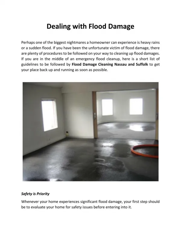
Spatial Flood Damage Function in Residential Area Ling-Fang Chang, Ming-Daw Su Data Collection and Studied Area In order to establish the flood damage function for one household in residential area, this study chose the basin of Keelung River, where flood disasters occur frequently, as the studied area. The data of questionnaires from the flood damage that was caused by Nari Typhoon in 2001 (Shaw 2004) is collected. The household who had flood experience before was investigated. The investigated areas include Xizhi City, Qidu District, Nangang District, Neihu District, SongShan District, Sinyi District and Da-an District. The contents of the questionnaire include disaster scale (the flood depth and inundated time), damage level (the damage of household furniture, decoration, and vehicles etc.), the basic information of household (the characteristics of the building like numbers of floors and area), and the factors of risk perception (the flood experience, risk information, scale of the risk, influence of mass media, whether one is willing to take the risk or not, whether the risk is controllable or not, fear of the risk). After deleting the incomplete data, the data that this study accepted is 302 in totals. Each data is geocoded to the map. ABSTRACT Over the past few years a considerable number of studies have been made on hydrology and hydraulics. In order to establish comprehensive risk management, it is necessary to build the flood damage function. Traditionally, ordinary least squares (OLS) method is used to build the flood damage function. It doesn’t consider the spatial variation and the residual is non- stationary with spatial. The purpose of the study is to establish the spatial flood damage function in residential area. The Geographically Weighted Regression (GWR)model is used. The result shows that R-square value is improved from 0.15 to 0.24, and the residual is stationary with spatial. It should be concluded that GWR model not only can capture the spatial variations, but also can improve the explanatory ability. Key Word:flood damage、flood depth、OLS、 GWR、 non- stationary Introduction Traditionally, flood damage function was estimated by Empirical Depth-Damage Curve. There are two methods of establishing the curve (Kang et al.,2005), one is constructed from the investigation of damage after the disaster (TVA,1969; FIA,1970; Grigg and Helweg,1975; Smith et al. ,1994); the other one is Synthesize approach (Chang,2000; Chang and Su,2001; Kang et al.,2005). The latter collected the data of the property items, possessive rate, and the height of the arrangement of the furniture, and also investigated the possible damage of each item during flooding in each depth. These two methods are different in the way of establishing the curve, but the common concept is to assume the flood depth is the only one factor of flood damage function. Nevertheless, is it enough for one household flood damage function only considers the single factor of flood depth? McBean et al.(1988) pointed out that except flood depth, there were many other factors that could influence the flood damage, for example, time of year of flooding, velocity of floodwaters, duration of flooding, sediment load, warning time, etc. Therefore, he recommended the flood damage function should be adjusted. Yang L. et al. (2005) also pointed out that except flood depth, some meteorological, physiographic and human factors such as rainfall, terrain and drainage etc. could affect the actual flood damage. Hence, many scholars continually study the relationships between other factors and flood damage. Among them the most common one is to consider the building type.(Grigg,1974; FEMA,1977; McBean et al.,1988; Smith,1994; Taiwan Water Resource Agency,1997; Chang,2000; Kang et al., 2005)。 The other factors include area of main floor, family income (McBean et al., 1988), flood warning system (Wind ,1999; David, 2000), flood warning lead time (Penning-Rowsell,2000), experience of flooding(McPherson, 1977; McBean et al., 1988; Wind 1999; Krasovskaia, 2001), the preparation before disaster (Penning-Rowsell and Fordham,1994), duration of flooding (McBean et al.,1988 ; Torterotot et al. 1992; Hubert et al. ,1996), velocity of floodwaters(CH2M Hill, 1974; Black,1975; Smith, 1994; Beck et al., 2002), number of people (McBean et al., 1988 ; Shaw, 2005), and the located area of the household (Chang, 2000; Shaw, 2005). Since the flood damage is affected by many factors, so some scholars incorporated all of the factors into the multiple regression model to establish the flood damage function in recent years(Shaw,2005). Although this method can incorporated all factors as the predictors and increase the R-square value, it also increases the difficulty of predictor’s data collection when predicting the damage. Besides, this method belongs to global multiple regression (Platt, 2004) and it is assumed the regression coefficient to be constant across the study region. In other words, it does not take account of the spatial variation, therefore the residuals from the global model often exhibit spatial autocorrelation (Fotheringham et al.,2002). It violates the assumption of linear regression. Thus, the purpose of this study is to establish the flood damage function for one household by using the least numbers of explained variables. In the meantime, it can also consider the spatial variation and solve the residual with spatial autocorrelation problems. Result Global Regression Model GWR model (Z value = 0.216<1.96) Discussion The result of global regression equation was shown in Figure 6. It showed that the damage variation was greater in low depth. The average total damage was $50,000 per household. Method Global Regression Model where, is the damage(NT dollar), is the depth(cm), 、 are the regression coefficients,, is the residual Residual Spatial Autocorrelation Testing Moran’s I GWR Model Conclusion Through this study’s result, it not only uses the least numbers of explained variables to establish the flood damage functions for one household, but also solves the problems of the traditional regression model that is unable to take account of the spatial variation, and it also modifies the residual with spatial autocorrelation. This study not only can seek a quantitative equation to describe the flood damage as a function of the flood depth, but also consider the spatial variation by GWR model. The coefficient of determination R-square is increased form 0.15 to 0.26. So the GWR model actually provided a better explanatory ability.