Download
1 / 1
10 likes | 150 Views
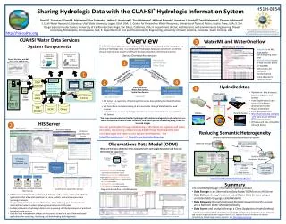
Map Server. Time Series Analyst. Base Station Computer(s). Telemetry Network. Sensors. HIS Server Website. HIS Server Capabilities Web Service. Sharing Hydrologic Data with the CUAHSI * Hydrologic Information System. Groundwater levels. Streamflow. H51H-0854. Precipitation & Climate.

E N D
Map Server Time Series Analyst Base Station Computer(s) Telemetry Network Sensors HIS Server Website HIS Server Capabilities Web Service Sharing Hydrologic Data with the CUAHSI* Hydrologic Information System Groundwater levels Streamflow H51H-0854 Precipitation & Climate Soil moisture data HIS Server Database Configuration Tool Flux tower data Water Quality David G. Tarboton1, David R. Maidment2, Ilya Zaslavsky3, Jeffery S. Horsburgh1, Tim Whiteaker2, Michael Piasecki4, Jonathan L Goodall5, David Valentine3, Thomas Whitenack3 Utah Water Research Laboratory, Utah State University, Logan, Utah, USA; 2. Center for Research in Water Resources, University of Texas at Austin, Austin, Texas, USA; 3. San Diego Supercomputer Center, University of California at San Diego, San Diego, California, USA; 4. Department of Civil, Architectural, and Environmental Engineering, Drexel University, Philadelphia, Pennsylvania, USA; 5. Department of Civil and Environmental Engineering, University of South Carolina, Columbia, South Carolina, USA. WaterOneFlow Services HIS Server Database Spatial Services WaterOneFlow WaterOneFlow WaterOneFlow This work was funded by the U.S. National Science Foundation under grant EAR 0622374. Any opinions, findings and conclusions or recommendations expressed in this material are those of the authors and do not necessarily reflect the views of the National Science Foundation. ODM ODM ODM http://his.cuahsi.org ODM Databases and WaterOneFlow Web Services ArcGIS Server Spatial Data Services Overview CUAHSI Water Data Services System Components WaterML and WaterOneFlow 3 The CUAHSI Hydrologic Information System (HIS) is an internet based system to support the sharing of hydrologic data. It is comprised of hydrologic databases and servers connected through web services as well as software for data publication, discovery and access. • Query functions • Return data in WaterML • WaterMLis an XML language for communicating water data • WaterOneFlowis a set of web services based on WaterML • OGC process for worldwide standardization • Some adoption by USGS and NCDC Service Oriented Architecture Data Discovery and Integration platform HIS Central Like search portals Google, Yahoo, Bing 1 1 Metadata Search Metadata Services Service and data theme metadata Service registration Data carts Catalog harvesting 4 2 3 HydroDesktop 4 Data Services Data Synthesis and Research platform Data Publication platform HIS Server HydroDesktop Water Data Services Spatial Data Services • Platform for data discovery, access, integration and analysis • Uses MapWindow 6 open source GIS software development toolkit • Plug-in architecture • Data abstraction layer • http://hydrodesktop.codeplex.com open source software development portal • Windows and Mac compatible (through Mono) Observations Like HTML Like web servers Like browsers GIS Models • HIS Server is a repository of hydrologic time series data published as WaterOneFlow web services; • HIS Central is a metadata catalog of data accessible through WaterOneFlow web services • Hydro Desktop accesses hydrologic data discovered on HIS Central and acquired from HIS Servers Climate Remote Sensing • The three components function for hydrologic information analogously to the internet as a whole comprised of web servers, browsers, and search portals interacting using HTML for text and images HIS Server 2 Dynamic controlled vocabulary moderation system You can participate through establishing a HIS Server to organize and share your data, discovering and accessing data through HydroDesktop and contributing to the open source system development. See http://his.cuahsi.org and http://www.hydrodesktop.org. Reducing Semantic Heterogeneity ODM Data Manager ODM Website Observations Data Model (ODM) ODM Controlled Vocabulary Moderator ODM Tools XML What are the basic attributes to be associated with each single data value and how can these best be organized? Master ODM Controlled Vocabulary ODM Controlled Vocabulary Web Services Local ODM Database HIS Server Platform independent Analysis Discovery and Access Query, Visualize, and Edit data using ODM Tools Hydro Desktop HydroExcel GIS Matlab Splus R IDL Java C++ VB http://his.cuahsi.org/mastercvreg.html • A relational database at the single observation level (atomic model) • Stores observation data made at points • Metadata for unambiguous interpretation • Traceable heritage from raw measurements to usable information • Standard format for data sharing • Cross dimension retrieval and analysis Streaming Data Loader ODM Database Service Registry WaterML Summary GetSites GetSiteInfo GetVariableInfo GetValues Excel, text HIS Central • The CUAHSI Hydrologic Information System provides • Data Storage in an Observations Data Model (ODM) on an HIS Server • Data Delivery through internet-based Water Data Services using a consistent data language, called WaterML • Data Discovery through federated thematic keyword search services and a National Water Metadata Catalog • Data Access and Analysis through a Client Application (HydroDesktop) Harvester Stage and Streamflow in ODM Example USGS NWIS Water Metadata Catalog WaterOneFlow Web Service ODM Data Loader • HIS Server is comprised of a collection of datasets, web services, tools, and software applications that allow data producers to store, publish, and analyze space-time hydrologic datasets. • Designed to permit local control of the data, while still being part of a distributed, national/international system allowing universal access to the data. • Enables producers of hydrologic data to join a growing, distributed network of published hydrologic data services. • Tools for local management of data on the server, as well as a set of Internet-based applications for accessing, visualizing, and downloading hydrologic data. EPA STORET NCDC Others * CUAHSI is the Consortium of Universities for Hydrologic Sciences, Inc. a consortium of 133 University and research organizations with support from the U.S. National Science Foundation to develop infrastructure for hydrologic science research. See http://www.cuahsi.org. Horsburgh, J. S., D. G. Tarboton, D. R. Maidment and I. Zaslavsky, (2008), A Relational Model for Environmental and Water Resources Data, Water Resour. Res., 44: W05406, doi:10.1029/2007WR006392.