Download
1 / 6
60 likes | 192 Views
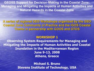
GEOSS Support for Decision-Making in the Coastal Zone: Managing and Mitigating the Impacts of Human Activities and Natural Hazards in the Coastal Zone

E N D
GEOSS Support for Decision-Making in the Coastal Zone: Managing and Mitigating the Impacts of Human Activities and Natural Hazards in the Coastal Zone A series of regional GEO Workshops organized by the GEO Coastal Zone Community of Practice and the IGOS Coastal Theme in partnership with GOOS and GTOS WORKSHOP 1Observing System Requirements for Managing and Mitigating the Impacts of Human Activities and Coastal Inundation in the Mediterranean Region June 9-13, 2008 Athens, Greece Michael S. Bruno Stevens Institute of Technology, USA
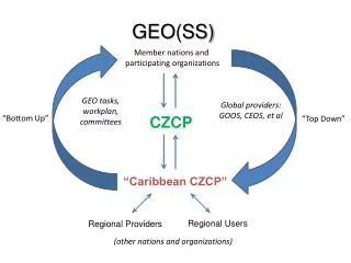
GEO Coastal Zone Community of Practice (CZCP), 2006. • A user-driven community of stakeholders • The purpose of the CZCP is to develop a strategy for engaging user groups across the land-sea interface in the development of those elements of the GOOS and GTOS that are required to provide and integrate data on terrestrial, freshwater, marine and atmospheric systems that converge in the coastal zone. Its specific objectives are to: • Engage data providers and users in the specification of requirements for in situ and remote observations • from data to products to information to knowledge • 2. Evaluate current and projected observation capabilities against these requirements, and identify gaps, redundancies and activities that need to be strengthened; • 3. Promote the development of workshops and “proof of concept” pilot projects; • 4. Promote development or strengthening of networks of institutions globally, regionally, and across Communities of Practice (CPs) that contribute to and benefit from GEOSSto achieve the mutual goals of GOOS and GTOS. • The CZCP will employ a regional approach to engage users and potential users through GOOS Regional Alliances (GRAs).
Coastal Observing Requirements • Common needs & gaps: • Existing global observing assets generally provide inadequate spatial, temporal and spectral resolution. • Continuity required of some existing capabilities for context and assessment of climate variability and change. • Some observations needed for coastal users not presently made, especially synoptically and/or from space. IGOS Coastal Theme Report, 2006
Woods (2006) Requirements: Large Scale - 100 km Physics Requirements: Small Scale < 1 km Ecology • “The coastal and estuarine scientific community has not yet developed strong links to GOOS because: • There are many diverse problems • Observation length and time scales differ from GOOS • Problems with going from global to local scales • GOOS serves only physics; many users require ecology-related products • No INTER-GOVERNMENTAL structure for articulating the needs of end-users”
“GEOSS Support for Decision-Making in the Coastal Zone: Observing Requirements for Coastal Development, Urbanization and Hazards”. • Objectives: • Specify data and information requirements of the Integrated Coastal Area Management (ICAM) community in developing nations, particularly longer-term planners, policy makers, and educators. • Discuss and prioritize data and information gaps identified in a separate pre-workshop effort. • Identify the challenges to filling these gaps, as well as the emerging decision-making approaches and model-based solutions. • Facilitate linkage of space-based observations, in situ measurements and models with sustained programs that will provide data and information needed to: • > Assess changes in susceptibility and resilience to coastal inundation and storm surge in high risk regions and • > Assess and forecast impacts on human health risks, the state of coastal ecosystems and the living resources they support • Initiate planning for a Coastal Data Assimilation System pilot project (CODAS) and corresponding Integrated Coastal Decision Support System (ICoDSS) for data acquisition, analysis, modeling and integration toward improved decision-making across the land-sea interface in two or more target regions.
Observing System Requirements for Managing and Mitigating • the Impacts of Human Activities and Coastal Inundation in the Mediterranean Region • Specific objectives of this Workshop • Compare scientifically sound scenarios for time-space extent of coastal inundation and storm surge in the coastal zone and for impacts of coastal flooding on coastal • infrastructure, • human health risks (exposure to waterborne pathogens), • ecosystems (e.g., water quality, habitats, biodiversity), and • living resources (organisms and habitats). • Assess current observing system capacities for providing the data and information required to assess changes in susceptibility (risk and resilience) both temporally (annual to decadal scales) and spatially (100 meter to 1 kilometer resolution). • Increase awareness among coastal planners and managers of geospatial patterns of susceptibility and causes of changes in susceptibility, both short term (e.g., coastal engineering) and long term (e.g., changes in sea level).