Download

1 / 53
530 likes | 635 Views
Learn how to operate the AN/PSN-11 Precision Lightweight GPS Receiver for precise positioning and navigation. Understand GPS concepts, physical features, characteristics, and operation objectives. Practice exercises for hands-on experience and practical application. Enhance your skills in setting up the PLGR, determining waypoints, and navigating effectively. Find out everything you need to know about this advanced GPS receiver.

E N D
AGENDA • PURPOSE • GPS CONCEPT • PHYSICAL FEATURES • CHARACTERISTICS • PLGR OPERATION OBJECTIVES • PLGR NAVIGATION • PRACTICAL EXERCISE • CONCLUSION
PURPOSE ENABLE THE USER TO OPERATE THE AN/PSN-11, PRECISION LIGHTWEIGHT GLOBAL POSITIONING SYSTEM (GPS) RECEIVER, TO FIND POSITIONAL DATA AND NAVIGATE FROM POINT TO POINT.
GPS CONCEPT • 24 SATELLITES IN 6 ORBITS, 6-9 ARE IN VIEW OF THE GPS RECEIVER AT ANY TIME • REQUIRES A MINIMUM OF 3 SATELLITES FOR LOCATION AND 4 FOR ELEVATION • UTILIZES PRECISE TIMING FROM SATELLITE TO RECEIVER TO DETERMINE LOCATION AND ELEVATION • REQUIRES LINE OF SIGHT TO SATELLITE RCVR • COMSEC ALLOWS MAXIMUM ACCURACY
GPS Satellite GPS Satellite GPS Satellite GLOBAL POSITIONING SYSTEM GPS Satellite LOCATION AND ELEVATION DETERMINED BY SIGNAL TIMING FROM SATELLITE TO GPS RECEIVER. GPS User Segment
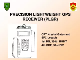
PHYSICAL FEATURES POWER BATTERY COVER KYK-13/KOI-18/ANCD CONNECTOR (COMSEC) DO NOT HIT CLR/MARK AND NUM/LOCK OR YOU WILL ZEROIZE THE DEVICE REAR PANEL CONNECTORS DISPLAY INTEGRAL ANTENNA KEYPAD HANDLE MEMORY BATTERY COVER
PLGR CHARACTERISTICS • ALL WEATHER OPERATION • NO SIGNALS EMITTED TO REVEAL YOUR POSITION • HOLDS 52 DATUMS • IS COMPATIBLE WITH NIGHT VISION DEVICES • RESISTS JAMMING (SPOOFING) • WATER-PROOF TO ONE METER • RUNS ON INTERNAL BATTERIES OR EXTERNAL POWER SOURCE • LITHIUM OR AA BATTERY ADAPTER • ADAPTER FOR 12 VDC OR 120 VAC
PLGR OPERATION OBJECTIVES • SETUP THE PLGR TO RECEIVE SATELLITE DATA. • DETERMINE YOUR PRESENT POSITION • INITIALIZE THE PLGR • ENTER WAYPOINTS • NAVIGATE TO A WAYPOINT
PLGR Cold Start or Standby • Cold Start: • If PLGR has not been used for a month or more or if the Almanac is old • Present position greater than one degree from last known position • Standby: • PLGR has been used within a few days AND present position within one degree of last known position
PLGR Cold Start • Physical check • Self-test check • Power battery check • Verify crypto loaded • Crypto loaded: SV equals all-Y • Crypto not loaded: SV equals mixed • Set operation mode to Continuous • Initialize position • Monitor FOM (=1) and almanac age (1 day) • Load waypoints
PLGR Standby • Physical check • Power battery check • Set operation mode to Continuous and SV type to mixed • Monitor FOM (=1) and almanac age (1 day) and load waypoints
3 MENU 2 1 ON BRT 5 6 4 9 NAV 7 WP 8 POS NUM LOCK CLR MARK 0 OFF TURNING ON THE PLGR FIXOLD 17S KS 45357e 34511n El +00134mP
PHYSICAL CHECK • Inspect PLGR for: • Dents, scratches, punctures • Unreadable data plates • Keys for cracks, breaks, unreadable markings • Display window for cracks or cloudy • Missing or loose hardware • antenna • covers • connectors
3 MENU 5 SELF-TEST CHECK • Upon power up - self-test status will be displayed • Or move select STATUS SETUP INIT TEST HELP <more> P STS GPS good Self-Test OK Internal antenna Vehicle power P
3 MENU 5 5 POWER BATTERY CHECK • Tan PLGR - 10 hrs, Green PLGR - 20 hrs • Upon power up - battery status will be displayed • Or move select STATUS SETUP INIT TEST HELP <more> P BATTERY:BA-5800 non-rechargeable 01h23m used RST 08h37m left P
PLGR BATTERIES • Memory Battery - not a AA battery, but AA size, replace yearly when loading new crypto • Power Battery - disposable • Tan case - 10 hours • Green case - 20 hours
2 1 ON BRT 1 ON BRT 5 BACKLIGHTING Hold the ON/BRT key and press the Up-arrow key. • This increases the display backlighting Hold the ON/BRT key and press the Down-arrow key. • This reduces the display backlighting
3 MENU 2 1 ON BRT 5 6 4 9 NAV 7 WP 8 POS NUM LOCK CLR MARK 0 OFF CRYPTO CHECK move select STATUSSETUP INIT TEST HELP <more> P DATA-XFRSV-SEL DOP-CALC ALERTS SINCGARS KOI-18 CRYPTO <more> P CUSTOM NAV <more> P
3 MENU 2 1 ON BRT 5 6 4 9 NAV 7 WP 8 POS NUM LOCK CLR MARK 0 OFF PLGR KEYPAD MENU SCREEN move select STATUSSETUP INIT TEST HELP <more> P DATA-XFRSV-SEL DOP-CALC ALERTS SINCGARS KOI-18 CRYPTO <more> P CUSTOM NAV <more> P
PLGR SETUP SCREENS • SETUP MODE • Mode of Operation, satellite type • SETUP UNITS • Coordinate system, units, north reference • SETUP MAGVAR • Magnetic Variation (MAGVAR) • SETUP • Local time • SETUP DTM • Datum, timer • 11 Setup screens total
SETUP MODEMode of Operation, SV-Type SETUP MODE: FIX Quick POS FIX, then STBY SV-TYPE:all-Y P CONT FIX AVG TIME STBY 2dTNG 3dTNG RHRSL mixed all-Y
SETUP UNITS SETUP UNITS MGRS-New Metric Elev:Feet MSL ANGL:Deg Mag P MGRS-Old MGRS-New UTM/UPS L/L-dm L/L-dms BNG ITMG Metric English NAUT True Mag Grid
MGRS UTM/UPS POSITION SCREEN(Coordinate System) CONT ±100ft 12A UTM/UPS 1234567e1234567n Elh +12345ftD P CONT ±100ft 12A MGRS-New AA 12345e 12345n Elh +12345ftD P
L/L dm L/L dms Position Screen(Coordinate System) CONT FOM=1 N 1234’56.78” W 01234’56.78” Elh +12345ftM P CONT ±100ft N 1234.567’ W 01234.567’ Elh +12345ftD P
SETUP MAGVARMagnetic Variation SETUP MAGVAR TYPE: Calc deg WMM 1995 P degrees deg min Mil-
SETUPElevation Hold,Time Display & Error Format SETUP Elhold: automatic TIME: Loc=Z-04:30 ERR: FOM P automatic manual FOM +m
MAP DATUM Datum Code Datum Description SETUP DTM:WGD WGS-84 AUTOMATIC OFF TIMER: 5min P off 5 minutes 15 seconds 20 minutes
A datum is a surveyed line or point that ensures all maps within a series will correctly match when placed edge to edge. Fifty-two map Datum sets are available within the PLGR. MAP DATUM
SETUP I/O SETUP I/O SERIAL:Standard HAVEQUICK: Off 1PPS: Off P
AUTOMARK SETUP AUTOMARK MODE: off WP001 01-13-00 1300L REPEAT 00h00m P off once rpt
PLGR CRYPTO • NSA certified that the PLGR is considered unclassified when keyed. • Loaded yearly or as required • Can be loaded with KYK-13, KOI-18, CYZ-10 • Key material gives the PLGR greater accuracy in positioning by accessing secure satellites too
8 POS POSITION SCREENS CONT OLD 17S MGRS-New KS 45367e 34511n Elh +00123m P TRACK / SEARCH 32 14 7 / 25 18 #VIS: 9 #GOOD: 7 ALM AGE: 1day P 0859:34L >10ms 02-12-00 SAT TRK 106.4 M GS 3kph P
PRESENT POSITION CONT OLD 17S KS 45367e 34511n El +00125m P
DYNAMIC INFORMATION 1135:05L >10ms 02-12-00 SAT TRK 104.7M GS 4mph P
TRACK/SEARCH TRACK/SEARCH 12 09 08 23 / 19 #VIS:9 #GOOD:9 ALM AGE:1day P
PLGR INITIALIZATION The PLGR has the ability to determine its’ present position, time, date, track and ground speed without any operator input.
3 MENU 5 INITIALIZE POSITION • Determine approx coordinates and elevation moveselect STATUSSETUP INITTEST HELP <more> P INIT POS CLR 17S KS 45367e 34511n Elh +00356ft P
HOW TO ENTER A WAYPOINT A waypoint is the location of a point on a desired course described by coordinates or a physical location. You can enter waypoints into the PLGR by map coordinates or by a known range, or azimuth from your present position.
7 WPT 5 WAYPOINT MENU(1000 WAYPOINTS: 0-999) PRESS WP <move> SEL ENTER EDIT COPY SR-CALC RNG-CALC DIST CLEAR ROUTE PRESS
WAYPOINT WAYPOINT NAME WAYPOINT # WP001 UNUSED001 B MGRS-New AN 00000e 00000n No EL CLR P GRID ZONE DESIGNATOR 100KM SQUARE DESIGNATION GRID ELEVATION CLEAR ENTRY
MARKING POSITION MARK position to WP:03 MARK03 MARK: saves ON: cancels PRESS Save CLR MARK CLR MARK Waypoint Cancel Waypoint 1 ON BRT
MARKING POSITION WAYPOINT MARKED
WP <move> SEL ENTER EDIT COPY SR-CALC RNG-CALC DIST CLEAR ROUTE 6 5 EDITING A WAYPOINT A B C : : M : : Z 0 1 2 = • Pull up the waypoint PRESS PRESS 7 WP PRESS WP: 42 MARK42 N 1234’56.78” W 01234’56.78” Elh +12345ft P WP: 42 MARK42 N 1234’56.78” W 01234’56.78” Elh +12345ft P
PLGR NAVIGATION Navigating is using the PLGR to locate various points on a map relative to your position. There are four navigating modes that may be accessed and selected.
5 9 NAV NAVIGATION PRESS SLOW DIRECT WP001 MARK001 P PRESS
5 6 NAVIGATION SCREEN 2D FAST DIRECT WP001 MARK001 P PRESS THREE TIMES PRESS ONCE
5 NAVIGATION SCREEN WP001 30m TRK 95.5ºM AZ 185.0ºM STR 30.5 P PRESS
NAVIGATION SCREEN RNG 60.0m TTG 0020:15 ELD +00003.0m MMD2 60.5P
9 NAV 6 Navigating to a Waypoint FAST SLOW 2D FAST CUSTOM SLOW DIRECT WP: 43 MARK43 P MARK43 OLD TRK n/a n/a STR n/a RNG 25.1 yds P
50 yds Navigating to a Waypoint MARK43 OLD TRK 90 T 1 kts STR RNG 35.5 yds P MARK43 OLD TRK 30 T 1 kts STR 60 RNG 50.2 yds P True North True North TRK 30 You are this dot and moving TRK Destination Waypoint Destination Waypoint STR 60 STR 35 yds 50 yds