Download
1 / 47
470 likes | 583 Views
Air Quality Community Experiences and Perspectives on International Interoperability Standards. Erin Robinson, Stefan Falke, Rudolf Husar, David McCabe, Frank Lindsay, Chris Lynnes, Greg Leptoukh, Beate Hildenbrand, Oleg Goussev, Peter Sommer. IGARSS, 30 July 2010 Honolulu,HI.

E N D
Air Quality Community Experiences and Perspectives on International Interoperability Standards Erin Robinson, Stefan Falke, Rudolf Husar, David McCabe, Frank Lindsay, Chris Lynnes, Greg Leptoukh, Beate Hildenbrand, Oleg Goussev, Peter Sommer IGARSS, 30 July 2010 Honolulu,HI Presented by Erin Robinson
Enforcing Standards Atmospheric Composition Informing the Public Hemispheric Transport Science & Education Regulatory Analysis Real-time Service Policy Assessment Air quality community spans efforts • Monitor the atmosphere (surface, satellite and aerial systems), • Model future atmospheric behavior and air quality conditions, • Measure and estimate emissions of pollution and pollution forming gases and particles, • Combine those information with socio-economic data for decision making analyses.
The Air Quality Web Landscape (not comprehensive – from a US perspective) Mediators NASA Programs/Projects • DataFed • Unidata • Giovanni • LAITS • RSG • CIERA/NEISGEI • VIEWS • RSIG • WRAP • EDAC • LAITS • Giovanni • 3D-AQS • RS for BlueskyRAINS • Aura in AQ Forecasting • VIEWS/TSS • SAMITS • Sensor Web Architecture & Demo (Mandl) • DAACS Portals / Catalogs • GEO Portals • Earth Observation Portal (GEO) • Geospatial One Stop • Environmental Science Connector (EPA) • Global Change Master Directory (GCMD) • ECHO (NASA) • LEAD (NSF) • AC Portal (CEOS/WGISS) EPA Programs/Projects • AMI • AirNOW • AQS • OAQPS • HTAP • Remote Sensing Gateway • Environmental Science Connector Interoperability Efforts • GALEON • ESIP • GEOSS AIP • CyAir • HTAP/AMEN Network NOAA Programs/Projects • Air Quality Forecasting • NESDIS • NGDC • Hazard Mapping System • IDEA and IDEA-I State • Aura in AQ Forecasting • RPOs • Vermont International Forest Service Programs/Projects • GMES • MACC • CEOS ACC • Bluesky
Traditional Project Approach Do something with the data (add value) Generate Product Data Deliver Product to Customer Closed System
Interoperability Challenges • Standalone-project-oriented approaches • Multiple interoperability standard implementations • Required tailored implementation of standards “The user cannot find the data; If he can find it, cannot access it; If he can access it, ; he doesn't know how good they are; if he finds them good, he can not merge them with other data” The Users View of IT, NAS 1989
Making Project Contributions Reusable Deliver Product to Customer Do something with the data (add value) Generate Product Data Provide Website Access (manual) Provide web service access Provide access to processing/analysis/value-adding services
Project A Project A combines multiple data sources to generate near-real time information for the public Project A provides web service interfaces to some of its data and information
Project B Project B analyzes surface and satellite data in support of regulatory analysis and provides web services to their analysis output and analysis tools
A new project uses services from projects A, B and C to meet its objectives New Project
SOA Actions Broker Publish– ISO 19115,19119 Find – OpenSearch BindOGC W*S User Provider The data reuse is possible through the service oriented architecture of GEOSS.
Community/Provider Catalogs Data Access Service Data Providers Metadata ISO 19115/19119 subset for Geospatial Data Data Protocol WMS, WCS (netDCF CF) + conventions
GEOSS CSR Data Access Service • Registration Specifies: • Where the records are located • Metadata standard • Harvest periodicity
GEOSS Clearinghouse harvests metadata from distributed catalogs Air Quality Community Record Data Binding OGC CSW Queryable OGC CSW Returnable Metadata Description ISO 19115CSW Profile
Data User Com Client Air Quality Community Record Air Quality Specific Data Binding OGC CSW Queryable OGC CSW Returnable Metadata Description ISO 19115CSW Profile
Data User Com Client Air Quality Community Record Air Quality Specific Data Binding OGC CSW Queryable OGC CSW Returnable Metadata Description ISO 19115CSW Profile
Server GetCapabilities Client Std. Interface Std. Interface Capabilities, ‘Profile’ Back End Where? When? What? Which Format? Front End GetData Data
HTAP Data Network • FZ Juelich server offers 1000+ HTAP model ‘datasets’ • WCS–netCDF–CF Standard Protocol • FZ Juelich & WashU Co-develop connectivity software Clients can access any HTAP model ‘datasets’ for browsing, comparison, statistical…processing DataFed Giovanni YOUR client software can also access any HTAP model ‘datasets’Perform your types of analyses The data the tools and the methods are shared to the Community through the AQ CoP So, participants of this project automatically become members of AQ CoP
CEOS Atmospheric Composition Portal • Objectives • Provide access, tools, and contextual guidance to scientists and value-adding organizations in using remotely sensed atmospheric composition data, information, and services • Help foster interoperability and application of atmospheric composition data, information and services worldwide • Start with DLR and NASA, work with partners in CEOS and the broader AC community in advancing the AC Portal GEO Task AR-09-02b User Contributed Content Users Contextual metadata GEOSS Data Access Gateways Visualization Tools Processing/Analysis Tools Beta version of the ACP by September 2010 OGC WMS DLR DLR DLR OPeNDAP Giovanni Giovanni Giovanni Initial focus on air quality but plan is to server broader community (climate, strat. O3) Datafed Datafed Datafed Put in back-up OGC WCS Others Others Others
CEOS Atmospheric Composition Portal Analyze difference
GEO AQ-CoPMain interaction through the open, participatory website: http://geo-aq-cop.org
Summary and Issues • The air quality interoperability efforts have found some success in using existing web standards to achieve a base level of interoperability • Many challenges remain spanning technical issues in making standards work for air quality uses to organization issues in achieving agreement among air quality-specific conventions to standards • As the community gains experience in how to implement and tailor the standards they will develop best practices • The interoperability efforts described in this abstract have focused on OGC standards. However, there is a desire to evaluate the applicability of other web standards for air quality systems, in particular OPeNDAP.
Acknowledgements This work is not done alone, acknowledge all of the people that contribute to this effort: • CEOS and Atmospheric Composition Portal • HTAP Network • CyAir • ESIP Air Quality Workgroup • GEOSS Architecture Implementation Pilots • GEO AQ Community of Practice
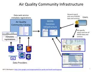
Air Quality Community Infrastructure Data web service metadata registrations General search and use of GEOSS data and services GEOSS Common Infrastructure Air Quality Community Catalog Users AQ-specific search and use of GEOSS data and services DataFed EDAC SEDAC Giovanni NGC ESA Data Providers AIP-2 Workspace: https://sites.google.com/site/geosspilot2/air-quality-and-health-working-group
Next Steps: • Continue to work with AQ community to improve the AQ-specific sections needed for sharper discovery • Work with AQ data providers to register their services in AQ Community Catalogs • Extend metadata with unstructured user-contributed content through DataSpaces • Use the GEOSS AQ CoP to help coordinate activities
Air Quality Community Interoperability Efforts(not comprehensive) • GEO AQ CoP: Working to connect various AQ networking activities • GEOSS AIP-3: The GEOSS Architecture Implementation Pilot (AIP) develops and deploys new process and infrastructure components for the GCI and the broader GEOSS architecture • HTAP: The HTAP network aims to facilitate seamless access to distributed HTAP model data, easy connectivity of data processing components through standard interfaces, and provide a set of basic tools for data processing, integration, and comparisons. • CEOS AC Portal: The AC Portal is being developed to provide access, tools, and contextual guidance to scientists and value-adding organizations in using remotely sensed atmospheric composition data • CyAir: Contributions to the planning, development, maintenance and coordination of systems to help the air quality community better utilize air quality related information
Infusing satellite Data into Environmental Applications (IDEA) A joint NASA-NOAA-EPA initiative: Objective -Prototype a near-real-time MODIS trajectory forecast product using MODIS direct broadcast aerosol optical depth over CONUS. • Goal - Improve accuracy of next day PM2.5 Air Quality Index (AQI) by providing pseudo-synoptic aerosol observations and trajectory forecast during large aerosol events. • Provides forecast guidance for surface air quality (PM2.5) • Dust storms • Smoke from forest fires • Urban/industrial haze • System requirements • Direct broadcast receiving station for satellite data • Trajectory model • Regional meteorological forecast model output • Algorithms to derive aerosol optical depth or related parameters • Surface mass aerosol monitors • System flexibility • Easily adaptable to other regions of the globe • Easy to modify to input other satellite data Benefit - Enable improved mitigation of health effects caused by episodes of poor air quality http://www.star.nesdis.noaa.gov/smcd/spb/aq/ Al-Saadi et. al., September 2005, Bulletin of American Meteorological Society
Giovanni Data Inputs MLS Aura Area Plot Time Series Model Output OMI Aura AIRS Aqua MODIS Aqua MODIS Terra Giovanni Instances SeaWiFS C A B TRMM B HALOE UARS A C E TOMS EP, N7 C F AMSR-E Aqua D MISR Terra F E D CloudSat CALIOP CALIPSO MERRA Models Correlations Column Densities Profile Cross-Section http://disc.sci.gsfc.nasa.gov/giovanni Slide provided by G. Leptoukh
IEEE Systems Journal, 2008 Design Concept SOA for Data Access & Processing Mediator for 100+ AQ Datasets Includes Tools for Analysis Applied to EPA EE Analysis Supported by NSF, NASA, RPOs, EPA Slide provided by R. Husar http://datafedwiki.wustl.edu/
Atmospheric Composition Portal GEO Task AR-09-02b User Contributed Content • Objectives • Provide access, tools, and contextual guidance to scientists and value-adding organizations in using remotely sensed atmospheric composition data, information, and services • Help foster interoperability and application of atmospheric composition data, information and services worldwide • Start with DLR and NASA, work with partners in CEOS and the broader AC community in advancing the AC Portal Users Contextual metadata GEOSS Data Access Gateways Visualization Tools Processing/Analysis Tools Plan is to have a beta version of the ACP by September 2010 OGC WMS DLR DLR DLR OPeNDAP Giovanni Giovanni Giovanni Initial focus on air quality but plan is to server broader community (climate, strat. O3) Datafed Datafed Datafed Put in back-up OGC WCS Others Others Others
CEOS Atmospheric Composition Portal Analyze difference
Hurdles “The user cannot find the data; If he can find it, cannot access it; If he can access it, ; he doesn't know how good they are; if he finds them good, he can not merge them with other data” The Users View of IT, NAS 1989
Remote Sensing Information Gateway Atmospheric Chemistry Earth Observations and Models Data Services AQ Data and Image Information Products Satellite: Primary Users NASA MODIS L2 AOD NASA CALIPSO L1b TAB NOAA GOES AOD (GASP) (Future data) NASA CALIPSO L2 Bext , AOD NASA MOPITT L2 CO NASA OMI L2 NO2 NOAA/NASA GOME-2 NO2 • Atmospheric Science Researchers • Air Quality Modelers and Analyst http://www.epa.gov/rsig RSIG System • - Subsetting • Regridding • Comparison • Export in common formats • Fast! Site Obs/Point Data: EPA AIRNow; O3, PM2.5 EPA AQS; O3, PM2.5 EPA UVNet; Irradiance RSIG WCS/WMS Servers Available for Other Systems Secondary Users • Air Quality Regulators and Managers • (RSIG is publicly-accessible.) Modeled: EPA CMAQ Concentrations, Met, Emissions, Deposition EPA Statically Fused Air and Deposition Surfaces O3, PM2.5 NOAA GOES Biomass Burning Emissions; PM2.5, NOx, CO, … Put in back-up Slide provided by J. Syzkman
To Support Hemispheric AP Transport Program • To Make a contribution to GEOS HTAP Data Network Juelich – M. Schultz DataFed – R. Husar Giovanni – G. Leptoukh
Other AQ CoP Ativities • AQ CoP Participation in GEO Tasks • • US-09-01b: Development of Communities of Practice • • US-09-01a: Identifying User Requirements for Earth Obs. • AR-09-01b: GEOArchitecture Implementation Pilot (AIP) • DA-09-02d: Atmospheric Model Evaluation Network • ….. • Meeting & Coordination Activities, 2009-10 • May 2009: Session on AQ and GEOSS, ISRSE, Stresa, Italy (Husar) • Jul 2009: AQ Community Infrastructure, ESIP, Santa Barbara, CA, US (McCabe) • Nov 2009: AQ Side Meeting at GEO-VI Plenary, Wash. DC, US (McCabe, Keating) • May 2010: GEO Decision Support Concept Proposal (Falke) • June 2010: AQ Participation in the GEOSS AIP 2,3. (Falke, Robinson) • Monthly: Telecons, Wiki workspace (Falke, Robinson)
AR-09-01b: GEO Architecture Implementation Pilot (AIP)Testing and Using the GEOSS Common Infrastructure (GCI) Catalog of AQ Data though the GEOSS Clearinghouse Time Space Data Search Facets Dataset Parameter Instr. Platform Sharing is facilitated by the GEOSS Common Infrastructure
GEO AQ-CoPMain interaction through the open, participatory website: • CoP People • Member Projects • DataSpaces
GEO AQ CoP Active Participants Technologists: Michael Decker, FZ Julich; Oleg Goussev (DLR); Kari Hoijarvi, WUSTL; Erin Robinson, WUSTL.. and others. Facilitators:Stefan Falke, NGC; Dave McCabe, EPA/CAC); Frank Lindsey, NASA; Rudy Husar, WUSTL; Martin Shulz, FZ Juelich .. and others. Agency Executives: Gary Foley, EPA; Terry Keating, EPA; Lawrence Friedl, NASA .. and others. Point of Contact: Rudolf Husar (rhusar@wustl.edu)
Outline • Define the infrastructure that is emerging in order to allow data sharing and reuse to occur • Identify the standards and conventions we are creating and the issues we’ve encountered • Describe a few of the AQ projects/programs and their international scope
HTAP Data Network • Stakeholders are autonomous organizations, scientists • Participation is largely voluntary • Information integration is key to success HTAP & GEOSS Symbiosis GEOSS is a good (system of systems) model for HTAP HTAP is a suitable use case for the emerging GEOSS HTAP Model Data Server Project: Connecting FZ Juelich server to WashU DataFed client