Download
1 / 9
140 likes | 624 Views
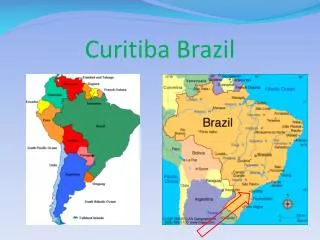
Curitiba. Urban Planning + Transportation. [ Charlette Caldwell + Julianne Cancalosi + Ron Ajel + Xiaxi Qiu ]. History of Curitiba. Founded in 1693 by Portuguese explorers as Nossa Senhora da Luz e Bom Jesus dos Pinhais.

E N D
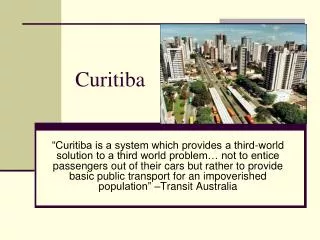
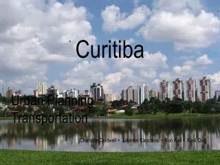
Curitiba Urban Planning + Transportation [Charlette Caldwell + Julianne Cancalosi + Ron Ajel + XiaxiQiu]
History of Curitiba Founded in 1693 by Portuguese explorers as NossaSenhora da Luz e Bom Jesus dos Pinhais Renamed Curitiba when the potential for successful agriculture was realized. Cattle herders and other farmers eventually replaced all of the unsuccessful gold miners. (The name Curitiba comes from kurítyba,Tupi for “many pine seeds.”) In 1854, Curitiba became the capital of Paraná 50 years later, German, Italian, Polish and Ukrainian immigrants pushed the population over 50,000 people. The population—supplemented by Japanese, Syrian and Lebanese immigrants—then tripled in the 1940s
History of Curitiba To help address the increase in population, French planner and architect Alfred Agache expanded the sewage system and rerouted roads to manage heavy traffic in the city. [This plan was actually more elaborate—involving star boulevards, public amenities downtown, an industrial district and sanitation—but was too expensive to completely see through] But the population continued to grow—to about 430,000 by the 1960s—subsequently outgrowing Agache’s system. In 1964, the Curitiba Master Plan was proposed by mayor IvoAruza and Jaime Lerner, and then was adopted in 1968 The Curitiba Master Plan aimed to: Minimize urban sprawl Reduce downtown traffic Preserve the historical district of Curitiba And provide affordable and easily accessible public transportation
Urban Planning + Zoning [Green Spaces] The Curitiba Master Plan [1968] focused on the integration of the land’s use of mobility. Jaime Lerner created the city’s first urban planning department [IPPUC] to help organize and direct further redevelopment efforts. The city layout was organized into a “radial” or axial system of structural arteries with main streets that divert traffic from downtown. There are 5 structural arteries from east to west. Creation of “Green Spaces” In the early 1970s, the United Nations declared that every urban inhabitant should have a minimum of twelve square meters of green area. [Curitiba had only half a square per inhabitant]
Urban Planning + Zoning [Green Spaces] Because of increasing poverty and deforestation in the 1980s, the urban planning department began to implement new eco-friendly and social programs for the city. “Green Spaces” were created along with various different parks dedicated to the assortment of ethnic groups living in Curitiba. Regional governments were instituted to abolish the central government. The bus transportation system was expanded and a color coded system was established for the various routes. [Curitiba now has 51 square meters of green area per inhabitant]
Bus Transportation History 1971 - Brazil’s first pedestrian network in the center of the city 1974 - creation of the road hierarchy Five arterial structural roads form the structural growth corridors and dictate the growth pattern Triple road system, central road having two restricted lanes dedicated to express busses. 1982 - all five structural corridors were completed with inter-district and feeder lines Zoning laws structure the growth of the city Large residential buildings permitted to be built along these corridors within urban area Admissible densities decline from urban apartment buildings to residential neighborhoods
Bus Transportation Current three complementary levels of service feeder lines express lines inter-district routes dedicated bus lanes operates much like a surface subway system ITN – Integrated Transportation Network. transfer terminals express routes night routes education routes pro-park routes [thirteen express lines make up the express bus system and operate on the structural corridors] multiple systems of managing fare failed current fare system single fare system doesn’t divide classes fare same price regardless of distance equivalent of 60 cents Fare
Responses to the urban planning in Curitiba Local Impact The program become part of the city's tradition. [e.g.] Every Saturday morning children would gather to paint the downtown street. Jaime Lerner created the first pedestrian street in Curitiba as a demonstration in 1972. After the plan was established population increased from 500,000 to 1.8 million. Nation-Wide Impact Compared to Sao Paulo, Curitiba has no extreme of wealth nor poverty disproportions. Most citizens are in the middle class sector. Curitiba has a different ecological city system compared to other cities in the country. For example, Brasilia is a city designed for cars. The rest of Brazil cities, for example Araucaria, have a oil refinery belching smoke on the city line. The ecological city system still need to be improved.
Responses to the urban planning in Curitiba International Impact Transmilenio in BogotuColombiaMetrovia in Guayaquil, EcuodorOrange line of LA Criticism • Trends of bus usage has observed a decline: noisy, crowded and unsafe. Political reason: Environmentalism rooted in authoritarianism. Decision made by military dictatorship instead of democracy.