Download
1 / 19
190 likes | 322 Views
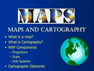
What is a Map?. Globes and maps. To learn about the Earth, two tools you can use are globes and maps . A globe is a model of the planet Earth as if seeing it from outer space. A globe is round and shows continents and oceans . There are seven continents on Earth and four oceans.

E N D
Globes and maps • To learn about the Earth, two tools you can use are globes and maps. • A globe is a model of the planet Earth as if seeing it from outer space. A globe is round and shows continents and oceans. There are seven continents on Earth and four oceans. • A map is a model of the Earth shown on a flat surface. Maps are useful because you can carry them with you. • Let’s look at a map more closely…
1. Find each of the seven continents on the map: North America, South America, Europe, Asia, Africa, Australia, and Antarctica. • 2. Find each of the oceans on the map: Atlantic Ocean, Pacific Ocean, Indian Ocean, and Arctic Ocean.
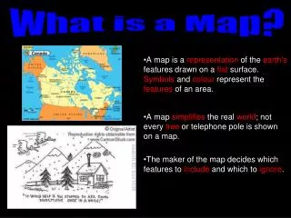
Elements on a map • Every map has five important elements: • Title • Legend/Key • Compass Rose • Scale • Inset Map • Each element has a purpose: • The title tells you the purpose of the map. • The legend shows you what symbols on the map mean. • The compass rose is a directional arrow that shows cardinal and sometimes intermediate directions on a map. • The scale is shown in both standard and metric measurements and show distance between objects on the map. • The inset map is a smaller map that shows a “larger” area of land around the map.
Using the Map key • Have you ever seen a star or a dot on a map? • The legend or map key will tell you what those symbols mean. • For example, the map key might tell you that a dot stands for a city. • The key might also indicate that a black line represents a state border. • It might show you how to identify a river with a blue line.
Why so many different maps? • Different cartographers (map-makers) use different map projections. • Another reason for this difference is that maps can be created to represent different features of the same places.
Why so many different maps? • One map of Europe might show only its major cities and state capitals. • Another might depict the country's different vegetation zones. • Another map might show Europe’s physical characteristics.
What differences do you see between these maps? • Do you see any similarities?
Political Maps • Look at the map on the right, why is it so colorful? • Maps that show countries, states, cities, and capitals are known as political maps.
Physical Maps • Physical maps show features of the Earth such as, mountains, rivers, oceans, and forests. • What other physical features are located on the map?
Other types of mapsThere are many other types of maps • Historical Maps • Road Maps • Climate Maps • Natural Resource Maps • Land Use Maps • Population Density Maps • Etc…
Scale • The map scale is used to show the relationship of distance shown on the map to real distance on the Earth.
The Coordinate system:Latitude and Longitude • On many maps you see crisscrossing lines with numbers by them. These lines and numbers form a grid system that allows us to describe the absolute, or exact, location of any place on Earth.
The Coordinate system:Latitude and Longitude • The lines running east to west around the Earth are called lines of latitude. They measure degrees north and south of the equator. Maps101.com
The Coordinate system:Latitude and Longitude • The lines running north to south around the Earth are called lines of longitude. They measure degrees east and west of the Prime Meridian. Maps101.com
The coordinate system • Together, lines of latitude and longitude form a grid system called the coordinate system. • When you state the coordinates of a place on the Earth you are giving its absolute location. Maps101.com
Now its your turn… Maps101.com