Download
1 / 29
290 likes | 450 Views
CENTRE FOR GEO-COMPUTATION STUDIES. HONG KONG. Towards a real-time landslide early warning strategy in Hong Kong. Qiming Zhou and Junyi Huang. Landslide Hazard in Hong Kong.

E N D
CENTRE FOR GEO-COMPUTATION STUDIES HONG KONG Towards a real-time landslide early warning strategy in Hong Kong Qiming Zhou and Junyi Huang
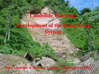
Landslide Hazard in Hong Kong Mass movement of rock, debris or earth down a slope, which can be triggered by various external stimuli, considered as one of the most damaging disaster in the world. Lam Tin, Kowloon (1982) Palacky University, Olomouc, Czech Republic, 18-22 November, 2013
Landslide Hazard in Hong Kong Man-made slope failure Natural terrain slope failure Encroachment of built environment and increasing risk of landslide Palacky University, Olomouc, Czech Republic, 18-22 November, 2013
Methodology • Landslide susceptibility mapping: • A quantitative or qualitative assessment of the classification, volume (or area), and spatial distribution of landslides which may potentially occur in an area. Geotechnical/ statistical model scale-adaptive physical/empirical model Palacky University, Olomouc, Czech Republic, 18-22 November, 2013
Research Framework • Study site selection and reconnaissance field investigation • Spatial data acquisition and specification • Hydrological ground data collection and rainfall/runoff analysis • Surface/sub-surface water discharge analysis • The development of landslide susceptibility and risk analysis model • Field tests and rainfall-runoff simulation experiment • Computer platform implementation • System calibration and evaluation Palacky University, Olomouc, Czech Republic, 18-22 November, 2013
Landslide Susceptibility Analysis • Historical landslide inventory (ENTLI database from CEDD) • Environmental parameters • Elevation (terrain slope and aspect, etc.) • Vegetation Index (NDVI) • Lithology (1:20,000 geology map) • Distance to fault line • Distance to major stream • Land cover • Landslide triggering factors and its consequence • Rainfall gauge data (archive, real time and forecast) • Service run-off • Soil hydorlogy • Risk analysis • Tertiary Planning Unit (TPU) census data 2011 • Transportation network • Tracts in conservation parks Palacky University, Olomouc, Czech Republic, 18-22 November, 2013
Landslide susceptibility Analysis • Digital Elevation Model (DEM) and its derivatives (slope, aspect, curvature, etc.) Landslide occurrence record (2000-2008), elevation and slope of Lantau Island, Hong Kong Palacky University, Olomouc, Czech Republic, 18-22 November, 2013
Landslide Susceptibility Analysis Vegetation cover rate Normalized Difference Vegetation Index (NDVI) and Major River in LantauIsland, Hong Kong Palacky University, Olomouc, Czech Republic, 18-22 November, 2013
Landslide Susceptibility Analysis • Frequency ratio model analysis LSI = Frelevation + FrNDVI + Frslope + Fraspect + Frfault distance + Frriver distance + Frlithology LSI: Landslide Susceptibility Index Fr: Frequency ratio of each causative factors Pixel in each category and percentage Classification Palacky University, Olomouc, Czech Republic, 18-22 November, 2013
Landslide Susceptibility Analysis Landslide susceptibility mapping result based on frequency ratio method Palacky University, Olomouc, Czech Republic, 18-22 November, 2013
m 30 50 90 125 (a) (b) (c) Degree of Importance (d) (e) Multi-scale DEM Palacky University, Olomouc, Czech Republic, 18-22 November, 2013
Systematic Random Stratified random The separation of DEM and hydrologic model Source sampling schema Palacky University, Olomouc, Czech Republic, 18-22 November, 2013
The flow vector on a triangular facet Palacky University, Olomouc, Czech Republic, 18-22 November, 2013
P1(x1, y1, z1) P3(x3, y3, z3) P2(x2, y2, z2) The slope and aspect of a triangular facet Palacky University, Olomouc, Czech Republic, 18-22 November, 2013
The flow direction of each source point Palacky University, Olomouc, Czech Republic, 18-22 November, 2013
Flow path tracking Palacky University, Olomouc, Czech Republic, 18-22 November, 2013
The flow path set Palacky University, Olomouc, Czech Republic, 18-22 November, 2013
The topology of the flow path network Node table Line table v = f(r, s, n) Palacky University, Olomouc, Czech Republic, 18-22 November, 2013
B A The flow path network Palacky University, Olomouc, Czech Republic, 18-22 November, 2013
Digital terrain model Palacky University, Olomouc, Czech Republic, 18-22 November, 2013
P t P t P t Rainfall simulator Spatial-temporal rainfall interpolation Stratified Random Sampling t x y Palacky University, Olomouc, Czech Republic, 18-22 November, 2013
t = 9s t = 127s t = 402s t = 734s t = 938s t = 1120s Rainfall event simulation
The flow generation at the source Ground observation Remote sensing Ground observation Soil and infiltration R = runoff; P = rainfall; E = evaporation; C = interception; I= infiltration Palacky University, Olomouc, Czech Republic, 18-22 November, 2013
Velocity and time From Manning Fomular: v = velocity(m/s)R = hydraulic radius(m) S = hydraulic slope n = Manning roughness coefficient L = flow path length(m) We have: Palacky University, Olomouc, Czech Republic, 18-22 November, 2013
Runoff generation and flow simulation • DTM: Based on S-DEM method to generate dynamic TIN • Simulated rainfall event: 20 minutes 12mm uneven rainfall event • Other environmental factors were not considered. Palacky University, Olomouc, Czech Republic, 18-22 November, 2013
0 - 0.27 m3/s 0.27 – 0.54 m3/s 0.54 – 2.7 m3/s > 2.7 m3/s Rainfall-runoff modelling t = 9s t = 127s t = 402s t = 734s t = 938s t = 1120s Palacky University, Olomouc, Czech Republic, 18-22 November, 2013
Rainfall-runoff modelling Palacky University, Olomouc, Czech Republic, 18-22 November, 2013
Research significance • Mapping the detail areas potentially affected by or susceptible to landslides in a timely manner in order to mitigate/prevent the related risk, and compare with/improves the previous model(s) • Integration of an interdisciplinary approach by integrating the geotechnical statistic methods and hydrological physical/empirical rainfall-runoff models • Big data geography with time-critical natural disaster monitoring or forecasting Palacky University, Olomouc, Czech Republic, 18-22 November, 2013
Thanks you for listening! Interested in studying in Hong Kong or China? Contact us! qiming@hkbu.edu.hk Palacky University, Olomouc, Czech Republic, 18-22 November, 2013