WinGIS
WinGIS. Geografisches Informationssystem & Microsoft Bing Maps. Key-Features. WinGIS. Desktop GIS Vektor- / Rasterdaten Integrierte Datenbank Multiuser-Fähigkeiten Import, Export (SHP, DXF, CSV, KML, …) GPS Unterstützung ISO-Modul Thematische Karten Raster Transformation

WinGIS
E N D
Presentation Transcript
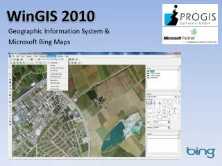
WinGIS Geografisches Informationssystem& Microsoft Bing Maps
Key-Features WinGIS Desktop GIS Vektor- / Rasterdaten Integrierte Datenbank Multiuser-Fähigkeiten Import, Export (SHP, DXF, CSV, KML, …) GPS Unterstützung ISO-Modul Thematische Karten Raster Transformation Developer Tools (SDK)
Microsoft Bing Maps als „embedded Module“in WinGIS WinGIS Bing Maps als „Layer“ Online-Zugriff mit Caching Straßen- / Geländekarten Orthofotos / Sat-Bilder Hybrid-Karten Geocoder DB-Geocoder Nutzungsabhängige Kosten (Transaktionen) oder Flatrate Vektordaten lokal / Luftbilder in der „Cloud“
Microsoft Bing Maps WinGIS NeueOrthofotos flächendeckend für Europa und USA Online bis Mitte 2012 Auflösung: 30 cm / Pixel Deutschland: 20 cm Auflösung Vexcel „UltraCam“
Bing Maps Silverlight WebControl WinGIS Kartenerstellung im WinGIS XML-Konvertierung Veröffentlichung am Web (Overlay) Datenbank-unterstützung
Sensor- / Telemetrie-Daten-Interface WinGIS Wetter- / Boden- / Maschinen-Daten Real-time Verortung und Visualisierung im WinGIS DB-Unterstützung Veröffentlichung am Web
Developer Tools (SDK) WinGIS COM / ActiveX-Schnittstellen Einfache Anbindung Datenbankverbindung Umfangreiche Funktions-bibliothek Direkter Zugriff auf Menüs und User-Interface Integrierbares GIS-Control(„Canvas“-Mode)
Produkte & Projekte WinGIS AGROffice/ DokuPlant (Agrar-Software) LoGIStic (z.B. Erntelogistik) PipeGIS (Leitungswesen) PROGIS MapServer (ORF – Reality Show „Taxi Orange“) FOMUMIIS (Umwelt- / Riskmanagment) BAU-MATIC (Bauamt- / Kommunalmanagment) TREE-MATIC (Forstapplikation) OIS – Objektinformationssystem für Feuerwehren u.a.
WinGIS PROGIS Software GmbH http://www.progis.com office@progis.com Bernhard Aigner GIS-Softwareentwicklung wingis@progis.com Online Shop http://shop.progis.com